Miva, Queensland
Miva is a locality split between the Gympie Region and the Fraser Coast Region in Queensland, Australia.[1][2]
| Miva Queensland | |||||||||||||||
|---|---|---|---|---|---|---|---|---|---|---|---|---|---|---|---|
 Country Women's Association rooms | |||||||||||||||
 Miva | |||||||||||||||
| Coordinates | 25°57′28″S 152°29′32″E | ||||||||||||||
| Postcode(s) | 4570 | ||||||||||||||
| Location | |||||||||||||||
| LGA(s) | |||||||||||||||
| State electorate(s) | Gympie | ||||||||||||||
| Federal Division(s) | Wide Bay | ||||||||||||||
| |||||||||||||||
Geography
Miva's eastern boundary is the Mary River. Its western boundary is the Bauple-Woolooga Road. Miva is almost entirely within the Gympie Region apart from a small section in the north-east of the locality which is part of the Fraser Coast Region. The lower parts of the locality near the river and along the valleys (elevation 20–70 metres are used for farming). The hilly land to the west rises to peaks of 100 metres and the hilly land to the south-east rises to a peak of 150 metres; the hilly land is undeveloped bushland. The former Kingaroy branch railway passed through Miva from the east to the south-west; Miva was served by the Miva railway station (25°57′30″S 152°29′30″E).[3][4]
History
The name Miva is taken from the name of a pastoral run belonging to Gideon Scott, a pastoralist in March 1851. It is thought to be an Aboriginal word indicating either stony knob or Moreton Bay chestnut.[1][2][5]
Miva Provisional School opened about 1888 becoming Miva State School on 1 Jan 1909. In 1922 became a halftime provisional school, sharing its teacher with the Sexton Provisional School, before closing in 1924. It reopened in 1926 as a provisional school, but closed finally about 1934.[6]
Miva Post Office opened by May 1908 (a receiving office had been open from 1888) and closed in 1976.[7]
Heritage listings
Miva has a number of heritage-listed sites, including:
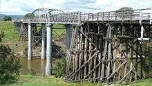
- across the Mary River: Dickabram Bridge[8]
Community groups
The Miva branch of the Queensland Country Women's Association meets at the QCWA Miva Rooms at 1186 Miva Road.[9]
References
- "Miva - Gympie Region (entry 47615)". Queensland Place Names. Queensland Government. Retrieved 2 March 2017.
- "Miva - Fraser Coast Region (entry 46742)". Queensland Place Names. Queensland Government. Retrieved 2 March 2017.
- "Miva - railway station (entry 22398)". Queensland Place Names. Queensland Government. Retrieved 2 March 2017.
- "Queensland Globe". State of Queensland. Retrieved 2 March 2017.
- "NOMENCLATURE OF QUEENSLAND.—194". The Courier-Mail. Brisbane: National Library of Australia. 14 May 1936. p. 14. Retrieved 8 July 2013.
- Queensland Family History Society (2010), Queensland schools past and present (Version 1.01 ed.), Queensland Family History Society, ISBN 978-1-921171-26-0
- Premier Postal History. "Post Office List". Premier Postal Auctions. Retrieved 10 May 2014.
- "Dickabram Bridge (entry 600836)". Queensland Heritage Register. Queensland Heritage Council. Retrieved 8 July 2013.
- "Branch Locations". Queensland Country Women's Association. Retrieved 26 December 2018.
External links
![]()