Maryborough, Queensland
Maryborough /ˈmɛrəbərə/[3] is a city and a suburb in the Fraser Coast Region, Queensland, Australia.[4][5] It is located on the Mary River in Queensland, Australia, approximately 255 kilometres (160 mi) north of the state capital, Brisbane. The city is served by the Bruce Highway. It is closely tied to its neighbour city Hervey Bay which is approximately 30 kilometres (20 mi) northeast. Together they form part of the area known as the Fraser Coast. As of June 2018 Maryborough had an estimated urban population of 27,282,[1] having grown slightly at an annual average of 0.12% year-on-year over the preceding five years.[1]
| Maryborough Queensland | |||||||||||||||
|---|---|---|---|---|---|---|---|---|---|---|---|---|---|---|---|
.jpg)   | |||||||||||||||
 Maryborough | |||||||||||||||
| Coordinates | 25.5375°S 152.7019°E | ||||||||||||||
| Population | 27,282 (2018)[1] | ||||||||||||||
| • Density | 159.82/km2 (413.94/sq mi) | ||||||||||||||
| Established | 1847 | ||||||||||||||
| Postcode(s) | 4650 | ||||||||||||||
| Elevation | 11.0 m (36 ft) | ||||||||||||||
| Area | 170.7 km2 (65.9 sq mi)[2] (2011 urban) | ||||||||||||||
| Time zone | AEST (UTC+10) | ||||||||||||||
| Location | |||||||||||||||
| LGA(s) | Fraser Coast Region | ||||||||||||||
| State electorate(s) | Maryborough | ||||||||||||||
| Federal Division(s) | Wide Bay | ||||||||||||||
| |||||||||||||||
| |||||||||||||||
History
Original inhabitants, language and culture
Evidence of human inhabitation of the Maryborough region stretches back to at least 6,000 years ago. The Gubbi Gubbi (Kabi Kabi) and Batjala (Butchulla) people were the original inhabitants of the region.[6] The Gubbi Gubbi were described as an inland tribe of the Wide Bay–Burnett area, whose lands extended over 3,700 sq. miles and lay west of Maryborough. The northern borders ran as far as Childers and Hervey Bay. On the south, they approached the headwaters of the Mary River and Cooroy. Westwards, they reached as far as the Coast Ranges and Kilkivan. The Batjala occupied the more coastal regions including K’gari (Fraser Island).
The Batjala and Gubbi Gubbi spoke dialects of the Dippil language, the Batjala dialect being spoken in the Fraser Coast region,[7] while the Gubbi Gubbi dialect was spoken in what is now the Gympie and Sunshine Coast regions.[8][9]
The escaped convict James Davis lived among various clans of the Gubbi Gubbi and John Mathew, a clergyman turned anthropologist, also spent five years with them and mastered their language. Dippil language was first described by the Reverend William Ridley on the basis of notes taken from an interview with James Davis in 1855.
The Queensland lungfish was native to Gubbi Gubbi waters and the species fell under a taboo among them, forbidding its consumption. It was known in their language as 'dala'. The Batjala considered porpoises to be of a status close to sacred.
The arrival of the British
British navigators Matthew Flinders in 1802 and William Edwardson in 1822 were the first Europeans to take detailed surveys of the Hervey Bay coastline. They both noted that the native population living on its shores appeared numerous. The first British people to live in the region were escaped convicts from the Moreton Bay Penal Settlement. Convicts Richard Parsons and John Graham both briefly lived with local Aboriginals during the late 1820s. James Davis, however, lived with several Gubbi Gubbi clans from 1829 to 1842. He became a member of their society and was given the name Duramboi.[6] In 1842, Andrew Petrie and Henry Stuart Russell sailed up the river known to the Gubbi as the Monoboola (later known as the Mary River) looking for land and timber to exploit. They found Duramboi living with the Ginginbara clan of the Gubbi along its banks at a camp close to where the town of Maryborough is now situated.[10]
Colonisation and conflict
After these initial explorations, pastoral squatters started to enter the region looking to establish sheep stations. The first of these was Mynarton Joliffe who, under the employment of the prosperous squatter John Eales, overlanded 16,000 sheep and set up the Tiaro property in 1843. Aboriginal resistance was fierce, shepherds and livestock were killed, and Joliffe had to abandon the area within eighteen months.[11] During this time, Commissioner of Crown Lands, Stephen Simpson visited the area and determined that the junction of two waterways (later known as the Mary river and Tinana Creek) would be a suitable place for a township.[6] Squatters started to return to the area in 1847 after John Charles Burnett conducted a more thorough survey of the region.[12][13]
Maryborough itself was founded in 1847 by George Furber who established a small wool depot on the banks of the river.[14] A year later Edgar Thomas Aldridge with Henry Palmer and his brother Richard E. Palmer constructed several permanent buildings and in 1849 a post office, petty sessions court and police station overseen by John Carne Bidwill opened. Edmund Blucher Uhr established a boiling down facility in 1850 and John George Walker started a boatyard not long after. The site for the township was laid out by the government surveyor H.H. Labatt in 1850 and the first land sales occurred in January 1852.[15] The name Maryborough was derived from the Mary River which itself was named in 1847 after Mary Lennox,[16] the wife of Charles Augustus Fitzroy who was the Governor of New South Wales at the time.
Aboriginal resistance remained determined with numerous Mary River squatters and their shepherds being wounded or killed. Within weeks of his arrival, George Furber was seriously wounded by local Aboriginal people,[17] as were other newly arrived colonists such as Alexander Scott.[18] Furber would later shoot dead the Aboriginal man who tried to kill him outside a store in Maryborough. The body of the man was then taken by the local Aboriginal tribe to a location about half a mile away, where it was cut up, roasted, and eaten. About two or three years later, Furber and his newly arrived son-in-law was killed by two Aboriginal men in 1855. One of the Aboriginal men who murdered Furber was named Minni-Minni, and said that the murder was retribution for Furber killing his mother on suspicion of stealing some flour and other articles from his tent.
In November 1850, after receiving intelligence of the murder of a shepherd and the loss of a flock of sheep, the Native Police started to enter the area. Lieutenant Richard Marshall with the assistance of Mary River settlers such as John Murray and Henry Cox Corfield, conducted expeditions to find the stolen sheep.[19] In 1851, the Commandant of the Native Police, Frederick Walker, was called in to apprehend a number of Aboriginal men who had committed criminal acts on the mainland, and were hiding out on Fraser Island.[20] Walker sailed with three sections of troopers down the Mary River. After landing at Fraser Island, the men who were guarding the boats saw a group of Aboriginal men in a stolen boat, which was then later captured. Another stolen boat was observed and shot at, with the Aboriginal crew escaping to a nearby island. While the men camped, the Aboriginal's tried to ambush them, with two of them were killed in the engagements. It was later discovered that the Aboriginal's had partly eaten one of the bodies. Another section captured a number of people while another section followed other inhabitants across to the east coast where they escaped into the ocean.[21][22] In 1856, a Native Police barracks was constructed on the outskirts of the town at Owanyilla. In early 1860, Lieutenant John O'Connell Bligh and his troopers conducted an early morning raid on a group of Aboriginal people, killing at least two and wounding many others, in the streets of Maryborough. The townspeople gave Bligh a sword thanking him for his actions.[23]
By the late 1860s Aboriginal resistance to colonisation in the Maryborough district had been defeated with the survivors existing in poverty as fringe-dwellers. Many of these people were forcibly transferred to an isolation camp on Fraser Island in the 1890s and later shipped to Far North Queensland to the Yarrabah facility.[24]
Sugar
The early Maryborough economy was centred around livestock farming, logging of the bunya pine forests, and the boiling down of animal carcasses to make tallow. In the late 1850s the soil along the Mary River was deemed ideal for the cultivation of sugarcane and in 1859 Edgar Thomas Aldridge was able to grow and produce a world-class experimental crop.[25] Seeing the profitable potential, many influential local landholders such as Henry Palmer and John Eaton formed the Maryborough Sugar Company in 1865.[26] Farmers switched to growing cane and the first Mary River sugar refinery, known as the Central Mill, was built in 1867 by Robert Greathead and Frederick Gladwell.[27]
At this time, other sugar plantations in Queensland were importing cheap, sometimes blackbirded labour from islands in the South Pacific. The planters along the Mary River also used this type of labour and the first shipment of 84 South Sea Islander workers arrived in Maryborough in November 1867. They came aboard the schooner Mary Smith, owned by Robert Greathead, with 22 of the labourers being engaged by the Maryborough Sugar Company.[28][29] Concerns were raised about whether the Islanders on the Mary Smith understood the work contracts and if the pledge to return them would be honoured due to the lack of an interpreter.[30] It was also alleged that the captain sold the Islanders to the colonists for £9 a head, while a missionary noted that the Islanders were unlikely to understand why they were taken.[31]
In 1869 Robert Tooth and Robert Cran bought up a number of plantations in the region and established the Yengarie Sugar Refinery. They became the local dominant sugar manufacturer with the Maryborough Sugar Company becoming insolvent. By the end of the 1870s, Robert Cran and his sons had taken control of operations under the name Cran & Co.
Economic and civic expansion
Maryborough was proclaimed a municipality in 1861, and became a city in 1905.[32] During the second half of the 19th-century, the city was a major port of entry for immigrants arriving in Queensland from all parts of the world.[33]
.jpg)
St Joseph's Catholic Primary School was established by Mary MacKillop and her Sisters of St Joseph of the Sacred Heart in July 1870. It closed in March 1879, as the consequence of a long-running dispute between MacKillop and the Roman Catholic Bishop of Brisbane, James Quinn, over whether the Sisters or the diocese should control the schools. In 1879 Quinn directed MacKillop and her sisters to leave the diocese, despite protests from the laity.[34][35] In 1880 the Sisters of Mercy arrived in Maryborough and re-opened the school as St Mary's School (now St Mary's Catholic Primary School).[36]
The first section of what is now the North Coast Line opened on 6 August 1881, connecting the mining town of Gympie to the river port at Maryborough and followed the Mary River valley. The Queensland Government was under constant pressure to reduce expenditure, and so despite the potential for the line to be part of a future main line, the line was constructed to pioneer standards with minimal earthworks, a sinuous alignment and 17.4 kg/m (35 lb/yd) lightweight rails.
Coal had been discovered at Burrum, 25 km north of Maryborough, and a line was constructed to serve the mine, opening in 1883. The line was extended to Bundaberg in 1888 so coal could be shipped there as well. When the Burrum line was built, it junctioned from the Maryborough line at Baddow, 3 km from the station, creating a triangular junction, with platforms ultimately being provided on all three sides. Maryborough station was situated immediately adjacent to the commercial centre of the city, and converting it into a through station would have been prohibitively expensive.

St. Thomas Anglican Church was opened in 1888[37] or 1891.[38] "St. Thomas's Anglican Church, a neat little edifice, was opened last week, most of the clergy about here being present at the opening ceremony. Two of our clergymen are now away on an extended holiday— the Rev. R. R. Eva, of St. Paul's, and the Rev. J. l. Knipe, of the Presbyterian Church."[39] It was closed 29 October 2005. Its closure was approved by Assistant Bishop Appleby.[38]
When through trains commenced running from Brisbane to Bundaberg and beyond, trains ran into Maryborough, a fresh steam locomotive was attached to the other end of the train, and it then departed.
.jpg)
Once diesel locomotives were introduced, there was no need to replace engines, and through trains paused at Baddow on the 3rd leg of the triangular junction before proceeding north. A one carriage connecting service was provided from Maryborough to meet the through train at Baddow, and then return. As trains became longer, the platform on the 3rd leg was not of sufficient length, and the trains would stop on the platform on the line to Maryborough, having to reverse out of, or back into the platform before proceeding further, adding about 15 minutes to the journey. The situation was finally resolved with the opening of the Maryborough West bypass in 1988.
Pneumonic plague
Australia's only outbreak of pneumonic plague occurred in Maryborough in 1905.[40] At the time Maryborough was Queensland's largest port—a reception centre for wool, meat, timber, sugar and other rural products. A freighter from Hong Kong, where plague was rampant, was in the Port of Maryborough about the time that a wharf worker named Richard O'Connell took home some sacking from the wharf, for his children to sleep on. Subsequently, five of the seven O'Connell children, two nurses, and a neighbour died from the disease. There were no more cases but the ensuing fear, panic, and hysteria totally consumed the town, and a huge crowd gathered to witness the family's house being burnt to the ground by health officials. A memorial fountain was built in the grounds of the City Hall and dedicated to the nurses, Cecelia Bauer and Rose Wiles.[41]
Further development
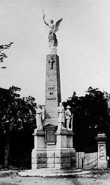
The foundation stone of Maryborough War Memorial was laid on 22 May 1921 by Lieutenant Colonel James Durrant. It was dedicated on 19 November 1922.[42]
The Andronicus Brothers - Jim and George, formerly from the Greek island of Kythera, established the Café Mimosa in Kent Street, Maryborough in the 1920s. Café Mimosa had a reception lounge above the café large enough to host sporting teams, wedding receptions, musical events and the Philharmonic choir during its practice sessions.[43]
The Maryborough Library opened in 1977 and underwent a major refurbishment in 2011. The Maryborough Toy and Special Needs Library opened in 2006.[44]
The city was the location for the 2013 Australian Scout Jamboree.
Heritage listings
Maryborough has a number of heritage-listed sites, including:
- 178-202 Adelaide Street: St Paul's Anglican Church and Hall[45]
- 271-275 Adelaide Street: St Mary's Roman Catholic Church[46]
- 210-220 Albert Street: Albert State School[47]
- Bazaar Street: Post Office Hotel[48]
- 227 Bazaar Street: Maryborough Post Office[49]
- Gympie Road to Ferry Street, across Mary River: Lamington Bridge[50]
- Kent Street: Maryborough Boys Grammar School Building[51]
- Kent Street: Maryborough Central State School[52]
- Kent Street: Royal Hotel[53]
- 297 Kent Street: former Royal Bank of Queensland[54]
- 310 Kent Street: Hotel Francis[55]
- 327 Kent Street: former Queensland National Bank[56]
- 331 Kent Street: Australian Joint Stock Bank [57]
- 388 Kent Street: Maryborough City Hall[58]
- 427 Kent Street: Maryborough School of Arts[59]
- Lennox Street: Maryborough railway station[60]
- 62-66 Lennox Street: Brennan & Geraghtys Store[61]
- 335 Lennox Street: Ilfracombe (house)[62]
- 115 March Street: Engineers' Arms Hotel [63]
- 50 Pallas Street: Oonooraba[64]
- 53 Pallas Street: Eskdale[65]
- 366 Queen Street: Baddow House[66]
- Richmond Street: Customs House[67]
- Richmond Street: Maryborough Courthouse[68]
- 164 Richmond Street: Maryborough Heritage Centre[69]
- Russell Street: Original Maryborough Town Site[70]
- Saltwater Creek Road: Second World War RAAF Buildings, Maryborough Airport[71]
- Sussex Street: Queen's Park[72]
- Walker Street: Maryborough Base Hospital[73]
- Walker Street, West Maryborough: Mortuary Chapel[74]
- Wharf Street: Government Bond Store[75]
- 96 Wharf Street: Maryborough Waterside Workers' Hall[76]
- 98 Wharf Street: Criterion Hotel[77]
- 106-108 Wharf Street & 310 Kent Street: Gataker's Warehouse Complex[78]
- 116 Wharf Street: Customs House Hotel[79]
- 123 Wharf Street: Maryborough Government Offices Building[80]
- 134 Wharf Street: Wharf Street Shop[81]
Economy and industry

Tourism plays a significant part in the economy of the city today. Maryborough is the self-styled Heritage City of Queensland and holds heritage markets each Thursday. The city has many preserved 19th and 20th century buildings including the General Post Office and Customs House.
The main industrial company in the city today is Downer Rail, formerly Walkers Limited, a heavy engineering business which has built much of the rolling stock and locomotives for Queensland Rail and in past years was involved in shipbuilding. Downer Rail, together with Bombardier Transportation, built and tested Transperth's relatively modern B-Series trains in Maryborough, which were launched in Perth in late 2004. It has built many trains for Queensland Rail. Bombardier Transportation closed its factory in Maryborough in December 2015.[82]
Maryborough Sugar Factory, in Kent Street was established in 1956. There were many smaller sugar mills which were established by sugar cane farmers along the Mary River. Island Plantation had one of the first sugar crushing mill set up along the river. One of the old settlements in Maryborough is at a place called Dundathu. Here the first timber mill was established in the 1800s. The timber was bought down the river and carted to the Timber Mill by horse and cart. The timber mill burnt down in the 1900s.
Maryborough's income also comes from numerous farming and station prospects in and around the city and has a healthy fishing industry. The city also has had traditional ties to the timber industry and is home to Hyne & Son one of the largest producers of natural timber products in Australia.
Maryborough was once a prominent centre of railway and tramway operations, including a branch to the wharf on the Mary River.[83][84]
Transport

Maryborough West station is on the North Coast line. It is served by long-distance Traveltrain services: the Spirit of Queensland, Spirit of the Outback and the Bundaberg and Rockhamption Tilt Trains.[85]
This station, on the western outskirts of the city, was built in the late 1980s as part of a seven kilometre new alignment built when the North Coast line was electrified.[86] It replaced Maryborough station in the central business district, although the eight kilometre branch remains in use to service the Downer Rail workshops.
Maryborough is served by Greyhound Australia coach services to Brisbane, Hervey Bay, Agnes Water and Cairns,[87] Premier Motor Services services to Brisbane and Cairns[88] and Tory's Tours services to Brisbane and Hervey Bay.[89]
Local bus services are provided by Wide Bay Transit as part of the QConnect network.[90]
Education
Primary
There are numerous primary schools in Maryborough. Some include: State
- Albert State School opened on 9 July 1883.[91]
- Maryborough Central State Infants School opened on 21 January 1878 and closed on 12 December 1986.[91]
- Maryborough Central State School opened on 10 March 1862.[91]
- Maryborough West State School
- Parke State School
- Sunbury State School
- Tinana State School
- Granville State School
- St Helens State School
Private
- Agnew College opened on 3 February 2003.[91]
- Riverside Christian College
- St Mary's Primary School
Secondary
State High
- Aldridge State High School
- Maryborough State High School
Private
- Riverside Christian College
- St Mary's College
Tertiary
- Wide Bay Institute of TAFE
Facilities
The Fraser Coast Regional Council operates a public library, the John Anderson Library, at 127-129 Bazaar Street.[92] It also operates a Toy and Special Needs Library at 239 Lennox Street.[93]
Ecology
Maryborough's environment supports rare and endangered terrestrial and aquatic fauna including the Mary River Turtle.[94]
Climate
| Climate data for Maryborough | |||||||||||||
|---|---|---|---|---|---|---|---|---|---|---|---|---|---|
| Month | Jan | Feb | Mar | Apr | May | Jun | Jul | Aug | Sep | Oct | Nov | Dec | Year |
| Record high °C (°F) | 38.4 (101.1) |
38.8 (101.8) |
36.6 (97.9) |
34.0 (93.2) |
31.5 (88.7) |
29.4 (84.9) |
28.5 (83.3) |
33.1 (91.6) |
34.1 (93.4) |
39.4 (102.9) |
37.5 (99.5) |
40.6 (105.1) |
40.6 (105.1) |
| Average high °C (°F) | 30.7 (87.3) |
30.2 (86.4) |
29.2 (84.6) |
27.4 (81.3) |
24.6 (76.3) |
22.4 (72.3) |
22.0 (71.6) |
23.4 (74.1) |
25.6 (78.1) |
27.7 (81.9) |
29.3 (84.7) |
30.5 (86.9) |
26.9 (80.4) |
| Average low °C (°F) | 20.6 (69.1) |
20.6 (69.1) |
19.4 (66.9) |
16.6 (61.9) |
13.0 (55.4) |
10.3 (50.5) |
8.6 (47.5) |
9.3 (48.7) |
12.1 (53.8) |
15.4 (59.7) |
17.8 (64.0) |
19.7 (67.5) |
15.3 (59.5) |
| Record low °C (°F) | 13.3 (55.9) |
14.4 (57.9) |
11.8 (53.2) |
6.7 (44.1) |
2.2 (36.0) |
−0.6 (30.9) |
−1.4 (29.5) |
−0.8 (30.6) |
1.5 (34.7) |
4.6 (40.3) |
8.2 (46.8) |
12.2 (54.0) |
−1.4 (29.5) |
| Average precipitation mm (inches) | 165.6 (6.52) |
174.7 (6.88) |
157.9 (6.22) |
87.4 (3.44) |
78.5 (3.09) |
67.5 (2.66) |
52.3 (2.06) |
40.6 (1.60) |
42.8 (1.69) |
73.7 (2.90) |
85.0 (3.35) |
129.4 (5.09) |
1,155.1 (45.48) |
| Average precipitation days | 13.1 | 13.8 | 14.5 | 11.8 | 10.6 | 8.3 | 7.1 | 6.2 | 6.4 | 7.9 | 9.0 | 10.7 | 119.4 |
| Source: [95] | |||||||||||||
Notable people
- Barbara J. Bain, an eminent haematologist at the Imperial College, and St Mary's Hospital, London, was born in Maryborough.
- Maurice Blair, rugby league player, was born in Maryborough.
- Arthur Cusack, Olympic swimming coach
- Robert Cusack, Olympic swimming medallist was born in Maryborough and coached by Maryborough's Arthur Cusack
- Jamie Charman, Brisbane Lions premiership ruckman, was born in Maryborough.
- Paul de Jersey, Chief Justice of Queensland grew up in Maryborough, where his father was the headmaster of Albert State School.
- Brendan Hansen represented Maryborough on the Maryborough City Council, Queensland State Parliament, and Federal Parliament.
- Mary Hansen of Stereolab was born in Maryborough (daughter of Brendan Hansen)
- Wilfred Hastings (Arch) Harrington (1906-1965), naval officer, was born in Maryborough.[96]
- Grant Kenny, ironman, was born in Maryborough in 1963.
- Margo Kingston, author and political journalist, was born in Maryborough but raised in Mackay.
- Joe Kilroy, rugby league player, was born in Maryborough.
- Lt-Col Albert Lambourn DSO, born in Maryborough and commanded NZ Field Artillery, WW2
- Arthur Lambourn, NZ Rugby Union All Black,was born in Maryborough and educated at Maryborough Central State School
- Clover Maitland, hockey player, comes from Maryborough
- John McBryde, hockey player, comes from Maryborough
- Don McWatters, hockey player, comes from Maryborough
- Mark Moffatt, musician and music producer, was born and educated in Maryborough.[97][98]
- Jenny Morris, hockey player comes from Maryborough.
- Larry Sengstock, former NBL player and now Basketball Australia CEO was born in Maryborough.
- David Theile, Olympic swimming medallist, was born in Maryborough and coached by Maryborough's Arthur Cusack
- P. L. Travers, author of the Mary Poppins books was born in Maryborough. She moved to Bowral at age eight.[99] Her father managed a bank, the Australian Joint Stock Bank, in the building where, in a room on the second storey, she was born. This is in the centre of town and still in use, no longer as a bank but as a retail shop. A life-size bronze statue of Mary Poppins, as P.L. Travers described her, complete with umbrella was erected outside the old bank premises at 331 Kent Street, on the corner of Richmond Street, in 2005. It is now one of Maryborough's most famous and photographed icons.[100]
In 2017, the Fraser Coast Regional Council established Maryborough's Walk of Achievers which places plaques along the streets of Maryborough celebrating the achievements of its residents.[101]
Rugby League side
Maryborough's premier rugby league side is the Maryborough Wallaroos, which competes in the Bundaberg Rugby League competition. The team won the Bundaberg competition in 2009 and won the Fraser Coast Rugby League competition in 2010 and 2011 after moving into that competition.
Sister city
Maryborough has one sister city, according to the Australian Sister Cities Association.
References
- "3218.0 – Regional Population Growth, Australia, 2017-18: Population Estimates by Significant Urban Area, 2008 to 2018". Australian Bureau of Statistics. Australian Bureau of Statistics. 27 March 2019. Archived from the original on 27 March 2019. Retrieved 25 October 2019. Estimated resident population, 30 June 2018.
- "2011 Census Community Profiles: Maryborough". ABS Census. Australian Bureau of Statistics. Archived from the original on 7 May 2018. Retrieved 15 September 2016.
- Macquarie Dictionary, Fourth Edition (2005). Melbourne, The Macquarie Library Pty Ltd. ISBN 1-876429-14-3
- "Maryborough - town in Fraser Coast Region (entry 21162)". Queensland Place Names. Queensland Government. Retrieved 6 November 2017.
- "Maryborough - suburb in Fraser Coast Region (entry 47502)". Queensland Place Names. Queensland Government. Retrieved 6 November 2017.
- Brown, Elaine Rosemary (2000), Cooloola Coast : Noosa to Fraser Island : the Aboriginal and settlers histories of a unique environment, University of Queensland Press, ISBN 978-0-7022-3129-2
- "Indigenous languages map of Queensland". State Library of Queensland. 2020. Retrieved 21 January 2020.
-

- "Indigenous languages map of Queensland". State Library of Queensland. 2020. Retrieved 21 January 2020.
- Russell, Henry Stuart (1888). The Genesis of Queensland. Sydney: Turner & Henderson.
- "NEWS FROM THE INTERIOR,". The Sydney Morning Herald. New South Wales, Australia. 25 July 1843. p. 3. Retrieved 26 April 2020 – via Trove.
- "Camp at Hawkins' Station". Sydney Chronicle. New South Wales, Australia. 26 June 1847. p. 4. Retrieved 26 April 2020 – via Trove.
- "RIVERS BURNETT AND MARY". The Moreton Bay Courier. Queensland, Australia. 25 September 1847. p. 3. Retrieved 26 April 2020 – via Trove.
- "Classified Advertising". The Moreton Bay Courier. Queensland, Australia. 5 June 1847. p. 1. Retrieved 26 April 2020 – via Trove.
- "THE EARLY DAYS". Maryborough Chronicle, Wide Bay And Burnett Advertiser. Queensland, Australia. 15 April 1903. p. 4. Retrieved 27 April 2020 – via Trove.
- "Mary River (entry 21155)". Queensland Place Names. Queensland Government. Retrieved 28 August 2015.
- "NEWS FROM THE INTERIOR". The Sydney Morning Herald. New South Wales, Australia. 8 November 1847. p. 2. Retrieved 26 April 2020 – via Trove.
- "DOMESTIC INTELLIGENCE". The Moreton Bay Courier. Queensland, Australia. 25 December 1847. p. 2. Retrieved 26 April 2020 – via Trove.
- "ORIGINAL CORRESPONDENCE". The Sydney Morning Herald. XXX (4280). New South Wales, Australia. 3 February 1851. p. 2. Retrieved 7 January 2018 – via National Library of Australia.
- "DOMESTIC INTELLIGENCE". The Moreton Bay Courier. VI (273). Queensland, Australia. 6 September 1851. p. 2. Retrieved 29 December 2017 – via National Library of Australia.
- "FRASER'S ISLAND". The Sydney Morning Herald. XXXII (4583). New South Wales, Australia. 22 January 1852. p. 2. Retrieved 29 December 2017 – via National Library of Australia.
- Skinner, L E (1975). Police of the Pastoral Frontier. UQP. pp. 64–66.
- Cryle, Denis (1 January 1989), The press in colonial Queensland : a social and political history, 1845-1875, University of Queensland Press, retrieved 27 April 2020
- Evans, Raymond (1999). Fighting Words: Writing about race. St Lucia: UQP. pp. 123–143. Archived from the original on 4 January 2018. Retrieved 4 January 2018.
- "MARYBOROUGH, QUEENSLAND". The Sydney Morning Herald. New South Wales, Australia. 18 January 1860. p. 3. Retrieved 28 April 2020 – via Trove.
- "Advertising". Maryborough Chronicle, Wide Bay And Burnett Advertiser. Queensland, Australia. 28 June 1865. p. 3. Retrieved 28 April 2020 – via Trove.
- "SUGAR-GROWING AT MARYBOROUGH". Queensland Times, Ipswich Herald And General Advertiser. Queensland, Australia. 14 March 1867. p. 4. Retrieved 28 April 2020 – via Trove.
- "TELEGRAPHIC". Maryborough Chronicle, Wide Bay And Burnett Advertiser. Queensland, Australia. 16 November 1867. p. 2. Retrieved 28 April 2020 – via Trove.
- "Advertising". Maryborough Chronicle, Wide Bay And Burnett Advertiser. Queensland, Australia. 6 November 1867. p. 3. Retrieved 28 April 2020 – via Trove.
- "THE SOUTH SEA ISLANDERS BY THE "MARY SMITH."". Maryborough Chronicle, Wide Bay And Burnett Advertiser. Queensland, Australia. 4 January 1868. p. 4. Retrieved 28 April 2020 – via Trove.
- "THE SOUTH SEA ISLAND LABOR QUESTION". The Queenslander. Queensland, Australia. 14 December 1867. p. 8. Retrieved 28 April 2020 – via Trove.
- "QUEENSLAND". The Sydney Morning Herald. National Library of Australia. 6 January 1905. p. 7. Retrieved 22 July 2013.
- "Harbour facilities". Fraser Coast Regional Council. Archived from the original on 14 February 2015. Retrieved 30 May 2012.
- Queensland Family History Society (2010), Queensland schools past and present (Version 1.01 ed.), Queensland Family History Society, ISBN 978-1-921171-26-0
- "Queensland". Sisters of Saint Joseph of the Sacred Heart. Archived from the original on 9 November 2019. Retrieved 9 November 2019.
- "About Us". St Mary's Catholic Primary School. Archived from the original on 9 November 2019. Retrieved 9 November 2019.
- "LOCAL NEWS". Maryborough Chronicle, Wide Bay And Burnett Advertiser (5, 451). Queensland, Australia. 17 January 1891. p. 2. Retrieved 31 May 2019 – via National Library of Australia.
- "Closed Churches". Anglican Records and Archives Centre. Archived from the original on 3 April 2019. Retrieved 31 May 2019.
- "Maryborough". The Telegraph (4, 989). Queensland, Australia. 6 October 1888. p. 5. Retrieved 31 May 2019 – via National Library of Australia.
- "Wide Bay Hospitals Museum Society". Fraser Coast Regional Council. Archived from the original on 14 July 2014. Retrieved 23 December 2012.
- Bauer and Wiles Memorial Fountain Archived 14 February 2015 at the Wayback Machine
- "Maryborough War Memorial". Monument Australia. Archived from the original on 7 April 2014. Retrieved 5 April 2014.
- Scheu, Anne (14 January 2020). "Cafe Mimosa, Maryborough". State Library of Queensland. Archived from the original on 14 January 2020. Retrieved 21 January 2020.
- "Public Libraries Statistical Bulletin 2016-17" (PDF). Public Libraries Connect. State Library of Queensland. November 2017. p. 15. Archived (PDF) from the original on 30 January 2018. Retrieved 30 January 2018.
- "St Pauls Anglican Church and Hall (entry 600705)". Queensland Heritage Register. Queensland Heritage Council. Retrieved 7 July 2013.
- "St Marys Roman Catholic Church (entry 600692)". Queensland Heritage Register. Queensland Heritage Council. Retrieved 7 July 2013.
- "Albert State School (entry 601525)". Queensland Heritage Register. Queensland Heritage Council. Retrieved 16 December 2017.
- "Post Office Hotel (entry 600691)". Queensland Heritage Register. Queensland Heritage Council. Retrieved 7 July 2013.
- "Maryborough Post Office (Place ID 106140)". Australian Heritage Database. Department of the Environment. Retrieved 1 October 2018.
- "Lamington Bridge (entry 600721)". Queensland Heritage Register. Queensland Heritage Council. Retrieved 7 July 2013.
- "Maryborough Boys Grammar School (former) (entry 600697)". Queensland Heritage Register. Queensland Heritage Council. Retrieved 7 July 2013.
- "Maryborough Central State School (entry 601264)". Queensland Heritage Register. Queensland Heritage Council. Retrieved 7 July 2013.
- "Royal Hotel (entry 600700)". Queensland Heritage Register. Queensland Heritage Council. Retrieved 7 July 2013.
- "Royal Bank (former) (entry 600699)". Queensland Heritage Register. Queensland Heritage Council. Retrieved 7 July 2013.
- "Hotel Francis (former) (entry 600696)". Queensland Heritage Register. Queensland Heritage Council. Retrieved 7 July 2013.
- "Queensland National Bank (former) (entry 600694)". Queensland Heritage Register. Queensland Heritage Council. Retrieved 7 July 2013.
- "Australian Joint Stock Bank (former) (entry 600693)". Queensland Heritage Register. Queensland Heritage Council. Retrieved 7 July 2013.
- "Maryborough City Hall (entry 600698)". Queensland Heritage Register. Queensland Heritage Council. Retrieved 7 July 2013.
- "School of Arts (entry 600701)". Queensland Heritage Register. Queensland Heritage Council. Retrieved 7 July 2013.
- "Maryborough Railway Station Complex and Air Raid Shelter (entry 600702)". Queensland Heritage Register. Queensland Heritage Council. Retrieved 7 July 2013.
- "Brennan & Geraghtys Store & two adjacent buildings and stables (entry 600704)". Queensland Heritage Register. Queensland Heritage Council. Retrieved 7 July 2013.
- "Ilfracombe (entry 600703)". Queensland Heritage Register. Queensland Heritage Council. Retrieved 7 July 2013.
- "Engineers' Arms Hotel (former) (entry 600695)". Queensland Heritage Register. Queensland Heritage Council. Retrieved 7 July 2013.
- "Oonooraba (entry 600707)". Queensland Heritage Register. Queensland Heritage Council. Retrieved 7 July 2013.
- "Eskdale (entry 600706)". Queensland Heritage Register. Queensland Heritage Council. Retrieved 7 July 2013.
- "Baddow House (entry 600690)". Queensland Heritage Register. Queensland Heritage Council. Retrieved 7 July 2013.
- "Customs House and Residence (former) (entry 600709)". Queensland Heritage Register. Queensland Heritage Council. Retrieved 7 July 2013.
- "Maryborough Court House (entry 600714)". Queensland Heritage Register. Queensland Heritage Council. Retrieved 7 July 2013.
- "Maryborough Heritage Centre (entry 600711)". Queensland Heritage Register. Queensland Heritage Council. Retrieved 7 July 2013.
- "Original Maryborough Town Site (entry 602393)". Queensland Heritage Register. Queensland Heritage Council. Retrieved 7 July 2013.
- "Second World War RAAF Buildings, Maryborough Airport (entry 602556)". Queensland Heritage Register. Queensland Heritage Council. Retrieved 7 July 2013.
- "Queen's Park (entry 600708)". Queensland Heritage Register. Queensland Heritage Council. Retrieved 7 July 2013.
- "Maryborough Base Hospital (entry 601907)". Queensland Heritage Register. Queensland Heritage Council. Retrieved 7 July 2013.
- "Mortuary Chapel (entry 600689)". Queensland Heritage Register. Queensland Heritage Council. Retrieved 7 July 2013.
- "Government Bond Store (former) (entry 600716)". Queensland Heritage Register. Queensland Heritage Council. Retrieved 7 July 2013.
- "Maryborough Waterside Workers' Hall (entry 600717)". Queensland Heritage Register. Queensland Heritage Council. Retrieved 7 July 2013.
- "Criterion Hotel (entry 600719)". Queensland Heritage Register. Queensland Heritage Council. Retrieved 7 July 2013.
- "Gataker's Warehouse Complex (entry 600718)". Queensland Heritage Register. Queensland Heritage Council. Retrieved 7 July 2013.
- "Customs House Hotel (entry 600715)". Queensland Heritage Register. Queensland Heritage Council. Retrieved 7 July 2013.
- "Maryborough Government Office Building (entry 600713)". Queensland Heritage Register. Queensland Heritage Council. Retrieved 7 July 2013.
- "Shop, 134 Wharf Street, Maryborough (entry 600720)". Queensland Heritage Register. Queensland Heritage Council. Retrieved 7 July 2013.
- "Skilled Queensland-based train manufacturers finish up work". ABC News. Archived from the original on 6 February 2016. Retrieved 17 January 2016.
- Armstrong, J. "The Railways of Maryborough". Australian Railway Historical Society Bulletin (August 1966): 170–182.
- "The Maryborough Wharf Branch". Australian Railway History (September 2007): 329–332, 366–368.
- Timetable Archived 22 December 2014 at the Wayback Machine Queensland Rail 16 December 2014
- Hansard Archived 22 December 2014 at the Wayback Machine Queensland Parliament 27 February 1986
- Timetables Archived 12 June 2018 at the Wayback Machine Greyhound Australia
- Timetables Archived 10 April 2013 at the Wayback Machine Premier Motor Service
- Timetable Tory's Tours
- Route Map Archived 26 December 2014 at the Wayback Machine Wide Bay Transit
- "Opening and closing dates of Queensland Schools". Queensland Government. Retrieved 18 April 2019.
- "Maryborough Library". Public Libraries Connect. State Library of Queensland. 27 March 2015. Archived from the original on 25 January 2018. Retrieved 24 January 2018.
- "Location and hours". Fraser Coast Regional Council. Archived from the original on 31 January 2018. Retrieved 31 January 2018.
- "The Serious Side". Mary River Festival. Archived from the original on 12 December 2013. Retrieved 6 December 2013.
- "Climate statistics for Maryborough". Bureau of Meteorology. Archived from the original on 10 May 2015. Retrieved 4 December 2013.
- Frame, Tom. Harrington, Sir Wilfred Hastings (Arch) (1906–1965). Canberra: National Centre of Biography, Australian National University. Archived from the original on 31 January 2016.
- "Nashville". AMPAL. Archived from the original on 29 February 2016. Retrieved 26 January 2016.
- "Nashville Soundcheck | Mark Moffatt". www.markmoffatt.com. Archived from the original on 5 February 2016. Retrieved 26 January 2016.
- Gibson, Lisanne; Joanna Besley (2004). Monumental Queensland: Signposts On A Cultural Landscape. University of Queensland Press. p. 179. Archived from the original on 7 May 2016. Retrieved 23 December 2012.
- "Mary Poppins Statue". Mary Poppins Festival. Fraser Coast Regional Council. Archived from the original on 20 August 2013. Retrieved 22 July 2013.
- "Walk of Achievers" (PDF). Fraser Coast Regional Council. Archived from the original (PDF) on 12 October 2017. Retrieved 13 October 2017.
Further reading
- Loyau, George Ettienne (1897), The history of Maryborough and Wide Bay and Burnett districts from the year 1850 to 1895, Pole, Outridge & Co, ISBN 978-1-921081-02-6 - full text available online
External links
| Wikimedia Commons has media related to Maryborough, Queensland. |
| Wikivoyage has a travel guide for Maryborough (Queensland). |
- University of Queensland: Queensland Places: Maryborough
- "Maryborough, a town of March county, Queensland, Australia". Encyclopædia Britannica (11th ed.). 1911.
- "Maryborough. A seaport municipality of March County, Queensland, Australia". New International Encyclopedia. 1905.
| Authority control |
|
|---|