Brooloo, Queensland
Brooloo is a town and locality in Gympie Region, Queensland, Australia.[2][3]
| Brooloo Queensland | |
|---|---|
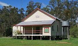 Brooloo Public Hall, established 1915 | |
 Brooloo | |
| Coordinates | 26°30′S 152°42′E |
| Population | 333 (2006 census)[1] |
| Postcode(s) | 4570 |
| Location | |
| LGA(s) | Gympie Region |
| State electorate(s) | Gympie |
| Federal Division(s) | Wide Bay |
Geography
The town is located in the hinterland behind the Sunshine Coast, 160 kilometres (99 mi) north of the state capital, Brisbane.
History
The Bluff Provisional School opened in July 1907. On 1 January 1909 it became The Bluff State School. In May 1915 it was renamed Brooloo State School. It closed in 1970.[4]
Brooloo Post Office opened by June 1915 (a receiving office had been open from March 1914). In 1922 the Brooloo Rail office was renamed Brooloo and replaced the previous office. It closed in 1972.[5]
At the 2006 census, Brooloo and the surrounding area had a population of 333.[1]
References
| Wikimedia Commons has media related to Brooloo, Queensland. |
- Australian Bureau of Statistics (25 October 2007). "Brooloo (Cooloola Shire) (State Suburb)". 2006 Census QuickStats. Retrieved 3 April 2009.
- "Brooloo - town (entry 4688)". Queensland Place Names. Queensland Government. Retrieved 25 June 2017.
- "Brooloo - locality (entry 46310)". Queensland Place Names. Queensland Government. Retrieved 25 June 2017.
- Queensland Family History Society (2010), Queensland schools past and present (Version 1.01 ed.), Queensland Family History Society, ISBN 978-1-921171-26-0
- Premier Postal History. "Post Office List". Premier Postal Auctions. Retrieved 10 May 2014.
This article is issued from Wikipedia. The text is licensed under Creative Commons - Attribution - Sharealike. Additional terms may apply for the media files.