Urangan, Queensland
Urangan is a coastal suburb of Hervey Bay in the Fraser Coast Region, Queensland, Australia.[2]
| Urangan Queensland | |
|---|---|
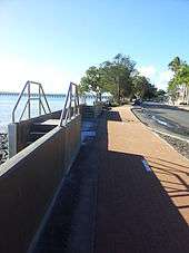
 The Esplanade, Urangan | |
 Urangan | |
| Coordinates | 25°18′9″S 152°53′19″E |
| Population | 9,169 (2011 census)[1] |
| Region | Fraser Coast Region |
Geography
To the east of the suburb lies the northern end of the Great Sandy Strait and Fraser Island. There is small marina at Urangan. Whale watching tours and ferries to Fraser Island depart from here.
The Great Sandy Region Botanic Gardens is located in Urangan on a 26 hectare site.[3] It houses a collection of about 20,000 orchids.
History
The Hervey Bay railway line from Maryborough passed through the suburb, terminating at the Urangan Pier. The line reached Pialba on 18 December 1896. However, construction of the extension to Urangan did not commence immediately as the original plan had been for the Vernon Coal and Railway Company to construct that section of the line to transport Burrum coal to the pier. However, the company did not build the line. On 20 December 1911, the Queensland Government decided to build the extension to Urangan, which was officially opened on 19 December 1913 by the Minister for Railways Walter Paget.[4]
The last ship docked at the Urangan pier in January 1985. In the far south west of the suburb is the single runway Hervey Bay Airport.
Sandy Strait State School was opened in 1995.
At the 2011 census, Urangan had a population of 9,169.[1]
Heritage listings
Urangan has a number of heritage-listed sites, including:
- Miller Street: Urangan Point State School, Block D[5]
Education
Sandy Strait State School caters for students from Prep to Year 6 and it opened in 1995. [6] [7] It is located on the western boundary of the suburb, adjacent to the State High School.
Urangan State High School caters for students from Years 7 to 12. [8] The school opened its doors on 1 January 1992.[7]
Amenities
The Urangan branch of the Queensland Country Women's Association meets at 19 Pulgul Street.[9]
See also
References
- Australian Bureau of Statistics (31 October 2012). "Urangan (State Suburb)". 2011 Census QuickStats. Retrieved 15 July 2013.

- "Urangan (entry 46686)". Queensland Place Names. Queensland Government. Retrieved 5 November 2015.
- "Hervey Bay Botanic Gardens". Queensland Holidays. Tourism and Events Queensland. Archived from the original on 3 September 2013. Retrieved 15 July 2013.
- Kerr, John (1990). Triumph of narrow gauge : a history of Queensland Railways. Boolarong Publications. pp. 91–92, 225. ISBN 978-0-86439-102-5.
- "Urangan Point State School, Block D (entry 601375)". Queensland Heritage Register. Queensland Heritage Council. Retrieved 7 July 2013.
- "Sandy Strait State School". Archived from the original on 2 February 2017. Retrieved 27 January 2018.
- "Opening and closing dates of Queensland Schools". Queensland Government. Retrieved 18 April 2019.
- "Urangan State High School". Archived from the original on 2 February 2017. Retrieved 27 January 2018.
- "Branch Locations". Queensland Country Women's Association. Archived from the original on 26 December 2018. Retrieved 26 December 2018.