Bella Creek, Queensland
Bella Creek is a rural locality in the Gympie Region, Queensland, Australia.[2] In the 2016 census, Bella Creek had a population of 43 people.[1]
| Bella Creek Queensland | |||||||||||||||
|---|---|---|---|---|---|---|---|---|---|---|---|---|---|---|---|
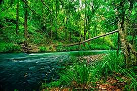 Yabba Creek at Bella Creek, 2017 | |||||||||||||||
 Bella Creek | |||||||||||||||
| Coordinates | 26.4777°S 152.5611°E | ||||||||||||||
| Population | 43 (2016 census)[1] | ||||||||||||||
| • Density | 1.547/km2 (4.01/sq mi) | ||||||||||||||
| Postcode(s) | 4570 | ||||||||||||||
| Area | 27.8 km2 (10.7 sq mi) | ||||||||||||||
| Time zone | AEST (UTC+10:00) | ||||||||||||||
| LGA(s) | Gympie Region | ||||||||||||||
| State electorate(s) | Gympie | ||||||||||||||
| Federal Division(s) | Wide Bay | ||||||||||||||
| |||||||||||||||
History
Bella Junction Provisional School opened on 28 May 1928 and closed on 11 July 1932.[3] The school was located at the junction of the Bella Creek and Yabba Creek beside the state forest reserve (at approximately 26.4912°S 152.5879°E).[4]
References
- Australian Bureau of Statistics (27 June 2017). "Bella Creek (SSC)". 2016 Census QuickStats. Retrieved 20 October 2018.

- "Bella Creek - locality in Gympie Region (entry 46304)". Queensland Place Names. Queensland Government. Retrieved 11 June 2019.
- Queensland Family History Society (2010), Queensland schools past and present (Version 1.01 ed.), Queensland Family History Society, ISBN 978-1-921171-26-0
- "EUMUNDI". The Brisbane Courier. Queensland, Australia. 29 October 1927. p. 12. Retrieved 21 February 2020 – via Trove.
This article is issued from Wikipedia. The text is licensed under Creative Commons - Attribution - Sharealike. Additional terms may apply for the media files.