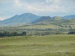
Bairin Left Banner
Baarin Left Banner (Mongolian: ᠪᠠᠭᠠᠷᠢᠨ ᠵᠡᠭᠦᠨ ᠬᠣᠰᠢᠭᠤ Baɣarin Jegün qosiɣu; Chinese: 巴林左旗; pinyin: Bālín Zuǒ Qí), or Bairin, is a banner of eastern Inner Mongolia, People's Republic of China. It is under the administration of Chifeng City, 195 kilometres (121 mi) to the south-southwest, and as of 2018 has a population of 340,020.[1] Baarin Mongols live here. The distinct Mongolian dialect of this region is called Baarin. It is located at the intersection of two national highways: China National Highway 303 and 305.
Bairin Left Banner 巴林左旗 • ᠪᠠᠭᠠᠷᠢᠨᠵᠡᠭᠦᠨᠬᠣᠰᠢᠭᠤ | |
|---|---|
Banner | |
 | |
 Baarin Zuoqi Location in Inner Mongolia | |
| Coordinates: 43°58′N 119°23′E | |
| Country | People's Republic of China |
| Region | Inner Mongolia |
| Prefecture-level city | Chifeng |
| Banner seat | Lindong (林东镇) |
| Elevation | 484 m (1,588 ft) |
| Population | |
| • Total | 340,020 |
| Time zone | UTC+8 (China Standard) |
| Postal code | 025450 |
| Area code(s) | 0476 |
History
Balin Left Banner has a long history, with the first archaeological digs dating to the 40th Century BC.[2] The capital of the Khitan-led Liao Dynasty, Shangjing (Chinese: 上京), was located here.[2] During the time of the Republic of China, many Han Chinese began moving to the area.[2] From the establishment of the People's Republic of China throughout the early 1980s, the area underwent numerous administrative reorganizations.[2]
Climate
Baarin Left Banner has a continental, semi-arid climate (Köppen BSk), with very cold and dry winters, hot, somewhat humid summers, and strong winds, especially in spring. The monthly 24-hour average temperature ranges from −13.1 °C (8.4 °F) in January to 22.8 °C (73.0 °F) in July, with the annual mean at 5.89 °C (42.6 °F). The annual precipitation is approximately 370 millimetres (14.6 in), with more than half of it falling in July and August alone. Due to the aridity and elevation, diurnal temperature variation often exceeds 15 °C (27 °F) in spring, averaging 13.7 °C (24.7 °F) annually. There are 2,934 hours of bright sunshine annually, with each of the winter months having over 70% of the possible total, and this percentage falling to 52 in July.
| Climate data for Baarin Left Banner (1981−2010 normals) | |||||||||||||
|---|---|---|---|---|---|---|---|---|---|---|---|---|---|
| Month | Jan | Feb | Mar | Apr | May | Jun | Jul | Aug | Sep | Oct | Nov | Dec | Year |
| Average high °C (°F) | −6.1 (21.0) |
−1.7 (28.9) |
5.4 (41.7) |
15.7 (60.3) |
22.9 (73.2) |
27.0 (80.6) |
28.5 (83.3) |
27.6 (81.7) |
22.5 (72.5) |
14.4 (57.9) |
3.1 (37.6) |
−4.2 (24.4) |
12.9 (55.3) |
| Daily mean °C (°F) | −13.1 (8.4) |
−9.2 (15.4) |
−1.9 (28.6) |
8.1 (46.6) |
15.8 (60.4) |
20.6 (69.1) |
22.8 (73.0) |
21.0 (69.8) |
14.7 (58.5) |
6.7 (44.1) |
−4.0 (24.8) |
−10.8 (12.6) |
5.9 (42.6) |
| Average low °C (°F) | −18.9 (−2.0) |
−15.9 (3.4) |
−9.2 (15.4) |
0.2 (32.4) |
7.7 (45.9) |
13.6 (56.5) |
17.0 (62.6) |
14.7 (58.5) |
7.2 (45.0) |
−0.3 (31.5) |
−9.8 (14.4) |
−16.4 (2.5) |
−0.8 (30.5) |
| Average precipitation mm (inches) | 1.1 (0.04) |
1.5 (0.06) |
4.6 (0.18) |
10.7 (0.42) |
24.1 (0.95) |
77.2 (3.04) |
118.1 (4.65) |
84.5 (3.33) |
31.2 (1.23) |
11.6 (0.46) |
4.3 (0.17) |
0.9 (0.04) |
369.8 (14.57) |
| Average precipitation days (≥ 0.1 mm) | 1.2 | 1.6 | 2.9 | 3.4 | 6.5 | 12.6 | 13.1 | 11.3 | 7.9 | 3.7 | 2.0 | 1.5 | 67.7 |
| Average relative humidity (%) | 47 | 42 | 39 | 35 | 38 | 56 | 68 | 69 | 59 | 48 | 49 | 49 | 50 |
| Mean monthly sunshine hours | 216.4 | 226.2 | 271.2 | 267.6 | 290.4 | 261.7 | 241.3 | 252.8 | 253.8 | 247.3 | 206.1 | 199.2 | 2,934 |
| Percent possible sunshine | 76 | 77 | 74 | 67 | 64 | 57 | 52 | 59 | 68 | 73 | 71 | 72 | 66 |
| Source: China Meteorological Administration (precipitation days and sunshine 1971–2000)[3][4] | |||||||||||||
References
- "中国 | 人口数:内蒙古:赤峰市:巴林左旗 | 经济指标". www.ceicdata.com. Retrieved 2020-03-05.
- "巴林左旗历史文化 - 历史文化 - 巴林左旗人民政府". www.blzq.gov.cn. Retrieved 2020-03-05.
- 中国气象数据网 - WeatherBk Data (in Chinese). China Meteorological Administration. Retrieved 2020-04-15.
- 中国地面国际交换站气候标准值月值数据集(1971-2000年). China Meteorological Administration. Archived from the original on 2013-09-21. Retrieved 2010-05-25.
- www.xzqh.org (in Chinese)
| Authority control |
|
|---|