Choibalsan (city)
Choibalsan (Mongolian: Чойбалсан) is the fourth-largest city in Mongolia after Ulaanbaatar, Darkhan, and Erdenet. The name of the city was Bayan Tümen (Баян Түмэн) until 1941, when it was renamed after the communist leader Khorloogiin Choibalsan. It is the capital of the province of Dornod. The city administrative unit's official name is Kherlen sum, with area of 281 square kilometres or 108 square miles. It is situated at the Kherlen River, at an elevation of 747 metres or 2,451 feet above sea level.
Choibalsan Чойбалсан ᠴᠣᠶᠢᠪᠠᠯᠰᠠᠩ | |
|---|---|
| Herlen District Хэрлэн сум ᠬᠡᠷᠦᠯᠦᠨᠰᠤᠮᠤ | |
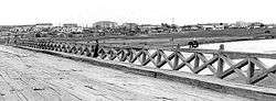 Bridge over the Kherlen River in Choibalsan (taken in 1972) | |
 Choibalsan | |
| Coordinates: 48°04′42″N 114°32′06″E | |
| Country | Mongolia |
| Province | Dornod Province |
| Area | |
| • Total | 281 km2 (108 sq mi) |
| Elevation | 747 m (2,451 ft) |
| Population (2017) | |
| • Total | 44,835 |
| • Density | 160/km2 (410/sq mi) |
| Time zone | UTC+8 (UTC + 8) |
| Area code(s) | +976 (0)158 |
| Website | www |
History
The location has been a post on a trading route for centuries. In the 19th century it grew into a city, and became the economic hub of eastern Mongolia in the twentieth century and is still serving as an active economic center for the Eastern Mongolia.
Due to the city's proximity to the site of the Battle of Khalkhin Gol, it contains a museum dedicated to Georgy Zhukov, hero of the battle.
Population
The city of Choibalsan has a population of 45,490 (1994), 41,714 (2000), 36,142 (2003), 39,500 (2006),[1] 39,500 (2007, 53.2% of the Dornod Aimag's total population),[2] 38,150 (2008 51.2% of the Aimag's population).[3]
Choibalsan is inhabited primarily by Halh Mongols, with smaller numbers of Buryats, Barga Mongols, and Üzemchin. There is also a minority of immigrants from China who now constitutes the only China Town in Mongolia outside Ulaanbaatar. This is a place worth of a short visit for outsiders.
Climate
Choibalsan experiences a cold semi-arid climate (Köppen BSk) with very cold, very dry winters and warm, wetter summers. In terms of temperatures it closely resembles a humid continental climate, but falls short of that classification due to the very dry winters. Extreme temperatures range from a minimum of −41.6 °C (−42.9 °F) to a maximum of 41.2 °C (106.2 °F),[4] recorded on June 25, 2010.[5]
| Climate data for Choibalsan | |||||||||||||
|---|---|---|---|---|---|---|---|---|---|---|---|---|---|
| Month | Jan | Feb | Mar | Apr | May | Jun | Jul | Aug | Sep | Oct | Nov | Dec | Year |
| Record high °C (°F) | 1.3 (34.3) |
8.4 (47.1) |
21.4 (70.5) |
29.5 (85.1) |
36.8 (98.2) |
41.2 (106.2) |
39.1 (102.4) |
38.3 (100.9) |
31.6 (88.9) |
28.0 (82.4) |
15.2 (59.4) |
3.5 (38.3) |
41.2 (106.2) |
| Average high °C (°F) | −14.4 (6.1) |
−10.7 (12.7) |
−0.5 (31.1) |
10.5 (50.9) |
19.0 (66.2) |
24.9 (76.8) |
26.6 (79.9) |
24.4 (75.9) |
18.0 (64.4) |
8.8 (47.8) |
−3.4 (25.9) |
−11.8 (10.8) |
7.6 (45.7) |
| Daily mean °C (°F) | −20.5 (−4.9) |
−17.7 (0.1) |
−7.8 (18.0) |
2.6 (36.7) |
11.3 (52.3) |
17.6 (63.7) |
19.8 (67.6) |
17.9 (64.2) |
10.6 (51.1) |
1.5 (34.7) |
−9.8 (14.4) |
−17.6 (0.3) |
0.7 (33.2) |
| Average low °C (°F) | −25.5 (−13.9) |
−23.9 (−11.0) |
−14.8 (5.4) |
−4.1 (24.6) |
3.8 (38.8) |
10.8 (51.4) |
14.4 (57.9) |
12.1 (53.8) |
4.9 (40.8) |
−4.2 (24.4) |
−15.2 (4.6) |
−22.7 (−8.9) |
−5.4 (22.3) |
| Record low °C (°F) | −41.6 (−42.9) |
−38.3 (−36.9) |
−36.6 (−33.9) |
−20.3 (−4.5) |
−8.7 (16.3) |
0.5 (32.9) |
4.4 (39.9) |
2.1 (35.8) |
−6.0 (21.2) |
−20.3 (−4.5) |
−29.9 (−21.8) |
−36.4 (−33.5) |
−41.6 (−42.9) |
| Average precipitation mm (inches) | 1.6 (0.06) |
1.9 (0.07) |
2.9 (0.11) |
6.3 (0.25) |
14.4 (0.57) |
39.0 (1.54) |
57.4 (2.26) |
43.3 (1.70) |
27.2 (1.07) |
7.7 (0.30) |
3.3 (0.13) |
2.6 (0.10) |
207.6 (8.16) |
| Average precipitation days (≥ 1.0 mm) | 0.6 | 1.0 | 0.7 | 1.6 | 3.2 | 5.7 | 8.7 | 8.1 | 4.6 | 1.6 | 1.1 | 0.9 | 37.8 |
| Mean monthly sunshine hours | 198.5 | 212.0 | 266.1 | 264.0 | 294.9 | 307.3 | 297.9 | 287.1 | 258.2 | 239.2 | 199.5 | 177.6 | 3,002.3 |
| Source: NOAA (1961-1990) [6] | |||||||||||||
Transportation
The Choibalsan Airport (COQ/ZMCD) has one paved runway, and is served by regular flights to Ulaanbaatar, and Hailar and Manzhouli in Inner Mongolia, China.
References
| Wikivoyage has a travel guide for Choibalsan. |
- Dornod Aimag: Статистикийн мэдээлэл 2006 (Statistical information), 2007-01-16
- Dornod Aimag Statistics Office
- Dornod Aimag Statistics Office.Dec. 2008 Report Archived 2011-07-22 at the Wayback Machine
- "Extreme Temperatures Around the World". Retrieved 13 January 2013.
- "Climate Choibalsan - year 2010". Retrieved 13 January 2013.
- "Choibalsan Climate Normals 1961-1990". National Oceanic and Atmospheric Administration. Retrieved January 13, 2013.
 | ||
Capital: Ulaanbaatar | ||
| ||