Manbij Subdistrict
Manbij Subdistrict (Arabic: ناحية منبج) is a subdistrict of Manbij District in Aleppo Governorate of northern Syria. The administrative centre is the city of Manbij.
Manbij Subdistrict ناحية منبج | |
|---|---|
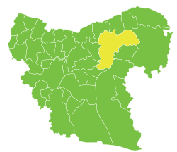 Location of Manbij Subdistrict within Aleppo Governorate | |
| Country | |
| Governorate | Aleppo |
| District | Manbij |
| Seat | Manbij |
| Area | |
| • Total | 1,219.88 km2 (471.00 sq mi) |
| Population (2004)[1] | 204,766 |
| Geocode | SY020500 |
At the 2004 census, the subdistrict had a population of 204,766.[1]
Cities, towns and villages
| Code | Name | Population |
|---|---|---|
| C1767 | Manbij | 99,497 |
| C1683 | Arab Hassan Kabir | 2,763 |
| C1731 | Hayyah Kabirah | 2,622 |
| C1687 | Awsajli Kabir | 2,431 |
| C1715 | Saan al-Ghazal | 2,002 |
| C1719 | Zunqul | 1,966 |
| C1716 | Khirfan | 1,780 |
| C1755 | Hajar Abyad | 1,724 |
| C1676 | Tal Yasti | 1,646 |
| C1738 | Mankubeh | 1,600 |
| C1679 | Farat | 1,568 |
| C1743 | Shweihet Kheznawi | 1,560 |
| C1783 | Big Kaber - Big Kaberjeh | 1,545 |
| C1734 | Um Myal Jafatlak | 1,527 |
| C1699 | Anzawiyeh Manbaj | 1,491 |
| C1752 | Little Hayyeh | 1,453 |
| #N/A | #N/A | 1,444 |
| C1730 | Um Adaset Elfarat | 1,431 |
| C1704 | Rafeeah | 1,338 |
| C1724 | Little Hamam | 1,325 |
| C1769 | Qanat Elghrra | 1,297 |
| C1674 | Rasm Elmashrafeh | 1,257 |
| C1739 | Rasm Elakhdar | 1,228 |
| C1791 | Qabab Bonyeh - Qarajleh | 1,197 |
| C1717 | Dadat | 1,168 |
| C1720 | Saidiyeh | 1,150 |
| C1711 | Tal Akhdar | 1,137 |
| C1741 | Jota | 1,127 |
| C1682 | Little Osajli | 1,093 |
| C1747 | Shanhasa | 1,075 |
| C1735 | Sghireh | 1,008 |
| C1762 | Oshrieh | 978 |
| C1781 | Big Madneh | 945 |
| C1764 | Hudhud | 909 |
| C1709 | Kherbet Nafakh | 875 |
| C1708 | Kherbet Massi | 872 |
| C1714 | Bir Kello | 846 |
| C1680 | Kherbet Elsheyab | 846 |
| C1689 | Tal Rafei | 828 |
| C1677 | Btoshiyet Manbaj | 808 |
| C1775 | Mashrafet Elbweir | 805 |
| C1684 | Jeb Elqader | 799 |
| C1697 | Jeb Elthor - Akrash | 799 |
| C1744 | Janat Saleh Eltayyeb | 793 |
| C1710 | Omriyeh | 788 |
| C1758 | Arnabiet Doshan | 786 |
| C1737 | Sayada | 770 |
| C1685 | Um Jalal | 756 |
| C1723 | Mahsana - Bak Weiran | 753 |
| C1681 | Um Jlud | 751 |
| C1756 | Big Jern | 742 |
| C1675 | Kherbet Elhsan | 727 |
| C1772 | Manilla Asaad | 703 |
| C1691 | Twal | 688 |
| C1746 | Um Edam | 688 |
| C1678 | Asaliyeh | 683 |
| C1688 | Dandaniya | 683 |
| C1721 | Sultahiyeh | 681 |
| C1729 | Ein Elnakhil | 661 |
| C1727 | Hamran | 646 |
| C1754 | Big Kharufiyeh | 639 |
| C1780 | Little Madneh | 626 |
| C1777 | Nejem Castle | 587 |
| C1700 | Um Elsateh | 578 |
| C1707 | Boyer | 564 |
| C1765 | Mgheirat | 525 |
| #N/A | #N/A | 482 |
| C1774 | Middle Warideh | 469 |
| C1733 | Little Kharufiyeh | 454 |
| C1785 | Qaber Imu | 453 |
| C1761 | Little Jern | 431 |
| C1750 | Sheikh Yehya | 422 |
| C1782 | Big Mohtaraq | 412 |
| C1784 | Little Mohtaraq | 398 |
| C1722 | Jeb Elarus | 376 |
| C1726 | Um Adase near Manbaj | 362 |
| C1701 | Jeb Abyad | 358 |
| C1706 | Big Jeb Elkalb | 350 |
| #N/A | #N/A | 336 |
| C1696 | Khishfet Um Adaseh | 332 |
| C1793 | Middle Majra | 331 |
| C1779 | Bir Quraa | 317 |
| C1702 | Jamusiyeh | 314 |
| C1712 | Hamduniyeh | 305 |
| C1773 | Upper Majra | 292 |
| C1753 | Safi | 290 |
| #N/A | #N/A | 290 |
| C1749 | Big Tahna | 282 |
| C1763 | Lower Majra | 282 |
| #N/A | #N/A | 281 |
| C1795 | Miloyran | 274 |
| #N/A | #N/A | 271 |
| C1748 | Kabiret Manbaj - Bashli | 249 |
| C1713 | Abu Jrin Manbaj | 215 |
| C1742 | Ratwaniyeh | 195 |
| #N/A | #N/A | 195 |
| C1768 | Karsan | 182 |
| C1789 | Moaysera | 164 |
| C1790 | Little Kaber - Little Kaberjeh | 111 |
References
- "2004 Census Data for Manbij nahiyah" (in Arabic). Syrian Central Bureau of Statistics. Archived from the original on 4 March 2016. Retrieved 15 October 2015. Also available in English: "2004 Census Data". UN OCHA. Retrieved 15 October 2015.
This article is issued from Wikipedia. The text is licensed under Creative Commons - Attribution - Sharealike. Additional terms may apply for the media files.