al-Bab District
al-Bab District (Arabic: منطقة الباب, romanized: manṭiqat al-Bāb) is a district of Aleppo Governorate in northern Syria. The administrative centre is the city of al-Bab.

The administrative center of al-Rai Subdistrict shown above is the city of al-Rai.
The administrative center of al-Bab Subdistrict shown above is the city of al-Bab.
The administrative center of Arima Subdistrict shown above is the city of Arima.

The administrative center of Tadef Subdistrict shown above is the city of Tadef.
al-Bab District منطقة الباب | |
|---|---|
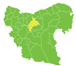
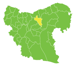
 Location of al-Bab District within Aleppo Governorate | |
 al-Bab District Location in Syria | |
| Coordinates (al-Bab): 36.3725°N 37.5178°E | |
| Country | |
| Governorate | Aleppo |
| Seat | al-Bab |
| Subdistricts | 4 nawāḥī |
| Area | |
| • Total | 1,480.19 km2 (571.50 sq mi) |
| Population (2004)[1] | 201,589 |
| Geocode | SY0202 |
The district was split in 2009, when three southern subdistricts were separated to form the new Dayr Hafir District.[2] At the 2004 census, the remaining subdistricts had a total population of 201,589.[1]
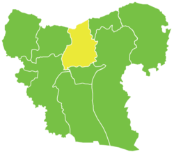
Subdistricts
The district of al-Bab is divided into four subdistricts or nawāḥī (population as of 2004[1]):
| Code | Name | Area | Population | Seat |
|---|---|---|---|---|
| SY020200 | al-Bab Subdistrict | 489.28 km² | 112,219 | al-Bab |
| SY020201 | Tadef Subdistrict | 321.24 km² | 41,951 | Tadef |
| SY020202 | al-Rai Subdistrict | 352.30 km² | 15,378 | al-Rai |
| SY020203 | Arima Subdistrict | 317.38 km² | 32,041 | Arima |
References
- "General Census of Population and Housing 2004" (PDF) (in Arabic). Syrian Central Bureau of Statistics. Archived from the original (PDF) on 8 December 2015. Retrieved 15 October 2015. Also available in English: "2004 Census Data". UN OCHA. Retrieved 15 October 2015.
- "إحداث منطقتي دير حافر والأتارب سيساهم في النهضة التنموية بالمحافظة". Al-Jamahir (in Arabic). Aleppo. 25 February 2009. Retrieved 24 January 2016.
Capital: Aleppo | ||||||||||||||||||||
|  | |||||||||||||||||||
|
| ||||||||||||||||||||
| ||||||||||||||||||||
| ||||||||||||||||||||
| ||||||||||||||||||||
| ||||||||||||||||||||
| ||||||||||||||||||||
| ||||||||||||||||||||
This article is issued from Wikipedia. The text is licensed under Creative Commons - Attribution - Sharealike. Additional terms may apply for the media files.