Atarib District
Atarib District (Arabic: منطقة الأتارب, romanized: manṭiqat al-Atārib) is a district of Aleppo Governorate in northern Syria. Administrative centre is the city of Atarib.
Atarib District منطقة الأتارب | |
|---|---|
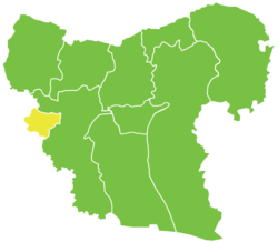 Location of Atarib District within Aleppo Governorate | |
 Atarib District Location in Syria | |
| Coordinates (Atarib): 36.13°N 36.82°E | |
| Country | |
| Governorate | Aleppo |
| Seat | Atarib |
| Subdistricts | 3 nawāḥī |
| Area | |
| • Total | 308.22 km2 (119.00 sq mi) |
| Population (2004)[1] | 76,873 |
| Geocode | SY0210 |
The district is located in the central western region of the Aleppo Governorate, sharing its west border with the Idlib Governorate. Until December 2008, it was a subdistrict of the neighboring Mount Simeon District.[2] At the 2004 census, the subdistrict had a population of 76,873.[1]
Subdistricts
The district of Atarib is divided into three subdistricts or nawāḥī:
| Code | Name | Area | Population | Seat |
|---|---|---|---|---|
| SY021000 | Atarib Subdistrict | km² | 32,186 | Atarib |
| SY021001 | Ibbin Samaan Subdistrict | km² | 21,925 | Ibbin Samaan |
| SY021002 | Urum al-Kubrah Subdistrict | km² | 22,851 | Urum al-Kubrah |
References
- "General Census of Population and Housing 2004" (PDF) (in Arabic). Syrian Central Bureau of Statistics. Archived from the original (PDF) on 8 December 2015. Retrieved 15 October 2015. Also available in English: "2004 Census Data". UN OCHA. Retrieved 15 October 2015.
- "إحداث منطقتي دير حافر والأتارب سيساهم في النهضة التنموية بالمحافظة". Al-Jamahir (in Arabic). Aleppo. 25 February 2009. Retrieved 24 January 2016.
Capital: Aleppo | ||||||||||||||||||||
|  | |||||||||||||||||||
|
| ||||||||||||||||||||
| ||||||||||||||||||||
| ||||||||||||||||||||
| ||||||||||||||||||||
| ||||||||||||||||||||
| ||||||||||||||||||||
| ||||||||||||||||||||
This article is issued from Wikipedia. The text is licensed under Creative Commons - Attribution - Sharealike. Additional terms may apply for the media files.