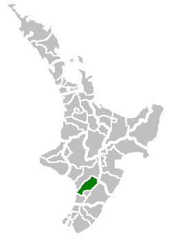
Manawatu District
The Manawatu District is a local government district in the Manawatū-Whanganui Region in the North Island of New Zealand.
Manawatu District | |
|---|---|
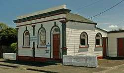 Rongotea Community Centre and Library (Dec. 2011) | |
 | |
| Country | New Zealand |
| Region | Manawatū-Whanganui |
| District | Manawatu District Council |
| Wards | Feilding Kairanga Kiwitea-Pohangina |
| Seat | Feilding |
| Government | |
| • Mayor | Helen Worboys |
| • Deputy Mayor | Michael Ford |
| Area | |
| • Total | 2,624.115 km2 (1,013.176 sq mi) |
| Population (June 2019)[1] | |
| • Total | 31,700 |
| • Density | 12/km2 (31/sq mi) |
| Time zone | UTC+12 (NZST) |
| • Summer (DST) | UTC+13 (NZDT) |
| Postcode(s) | |
| Website | Manawatu District Council |
The district is based on the town of Feilding and includes most of the area between the Manawatu River in the south and the Rangitikei River in the north; stretching from slightly south of the settlement of Himatangi in the south, to just south of Mangaweka in the north; and from the Rangitikei River to the summits of the Ruahine Ranges in the east. The district does not include the area around Foxton, Foxton Beach or the mouth of the Manawatu River. It also excludes the area around the city of Palmerston North (including Ashhurst). The district has an area of 2,624 km².
Name
Manawatu is said to have been named by Hau, a great Māori explorer. When searching for his wife who had left him for another lover, Hau is said to have pursued her along the south west coast of the North Island. As he travelled, he came across and named river mouths including Whanganui, Whangaehu and Rangitikei according to events that befell him at the time. He came across a large, wide river mouth. In awe of the sight and in fear he might not be able to cross it, he stated "Ka tū taku manawa" (My heart stands still).[2]
The term Manawatu (often the Manawatu) also refers to the whole geographical region centred on the floodplain of the Manawatu River, with Palmerston North as its principal city. Like several other geographical regions in New Zealand, such as Wairarapa and the King Country, the Manawatu in this sense never had precisely defined borders, its extents determined largely by custom and preference. Always included however are Palmerston North and all of today's Manawatu district and usually included is that part of Horowhenua district lying north of Levin. Parts of Rangitikei and/or Tararua districts might also be included.
Population
The district has a population of 31,700 as of June 2019.[1] Feilding, the district seat, has a population of 16,450 and is the only town in the district with a population over 1,000. Other towns and settlements in the district include Halcombe, Himatangi Beach, Kimbolton, Pohangina, Rongotea, Sanson, and Tangimoana.
Demographics
| Historical population | ||
|---|---|---|
| Year | Pop. | ±% p.a. |
| 2006 | 26,070 | — |
| 2013 | 27,459 | +0.74% |
| 2018 | 30,165 | +1.90% |
| Source: [3] | ||
Manawatu District had a population of 30,165 at the 2018 New Zealand census, an increase of 2,706 people (9.9%) since the 2013 census, and an increase of 4,095 people (15.7%) since the 2006 census. There were 11,193 households. There were 14,943 males and 15,222 females, giving a sex ratio of 0.98 males per female. Of the total population, 6,282 people (20.8%) were aged up to 15 years, 5,004 (16.6%) were 15 to 29, 13,473 (44.7%) were 30 to 64, and 5,406 (17.9%) were 65 or older. Figures may not add up to the total due to rounding.
Ethnicities were 89.2% European/Pākehā, 16.5% Māori, 2.0% Pacific peoples, 2.6% Asian, and 2.0% other ethnicities. People may identify with more than one ethnicity.
The percentage of people born overseas was 10.6, compared with 27.1% nationally.
Although some people objected to giving their religion, 52.4% had no religion, 35.4% were Christian, and 3.6% had other religions.
Of those at least 15 years old, 3,657 (15.3%) people had a bachelor or higher degree, and 5,595 (23.4%) people had no formal qualifications. The median income was $32,400. The employment status of those at least 15 was that 12,321 (51.6%) people were employed full-time, 3,498 (14.6%) were part-time, and 726 (3.0%) were unemployed.[3]
Local government
.JPG)
District Council
Manawatu District Council was formed by the amalgamation of the Feilding Borough, Kiwitea County, Manawatu District, Oroua County and Pohangina County Councils in the 1989 local government reforms.
For the purposes of representation, Manawatu District is divided into three wards:
| Ward name | Number of councillors | Area included |
|---|---|---|
| Feilding | 5 | Feilding (urban) |
| Kairanga | 3 | Rongotea, Sanson, Himatangi Beach, Ohakea, Bainesse, Kairanga (north of Kairanga Bunnythorpe Rd, Longburn (west of the NIMT), Karere, Tangimoana. (Rural south) |
| Kiwitea-Pohangina | 2 | Kimbolton, Halcombe, Cheltenham, Waituna West, Rangiwahia, Apiti. (rural north) |
The council is responsible for day-to-day administration and services:
- Animal control
- Bylaws
- Cemeteries
- Community grants and funding
- Infrastructure such as roads, drains, rubbish collection.
- Library services
- Liquor licensing
- Property profiling.
Mayor

Ian McKelvie was first elected mayor in a by-election in November 2002. After being elected to Parliament in the 2011 election, he resigned from the mayoralty on 15 December 2011.[4][5] Deputy Mayor Matt Bell was then acting mayor until a by-election held on 7 March 2012.[5] The by-election was narrowly won by Margaret Kouvelis from Feilding, who beat councillor Steven Gibson by just 14 votes (3293 votes to 3279).[6] Helen Worboys won the mayoralty from the incumbent Margaret Kouvelis in the 2016 Local Government elections.
Horizons Regional Council
Manawatu District is in the Manawatū-Whanganui Region, which is governed by the Horizons Regional Council. For electoral and representation purposes, the district is divided into:
- Horowhenua-Kairanga Ward: rural area south of Feilding, including the entire Horowhenua District.
- Manawatu-Rangitikei Ward: Feilding and rural area to the north, and including the entire Rangitikei District.
Tourism
The Manawatu district includes both plains and hills, and is visited by cyclists and others for the views of the Central North Island volcanoes on clear days. The western coast has swimming beaches and large sand dunes, while the Ruahine Ranges in the east has walking tracks and views over the district from the Wharite mountain or from the Saddle Road.
In the middle of the district is Feilding, with its saleyards, equestrian and motorsport venue (Manfeild), boutique shopping and historical landmarks and collections.
Manawatu is the location of the Royal New Zealand Air Force's main base, RNZAF Base Ohakea.
Schools
Secondary
- Feilding High School - Feilding
- Hato Paora College - Cheltenham
Secondary
- Feilding Intermediate School - Feilding
Primary
- Manchester Street School - Feilding
- Mount Biggs School
- Lytton Street School
- North Street School
- St Joseph's School
- Colyton School
- Taonui School
- Kiwitea School
- Apiti School
- Utuwai School
- Cheltenham School
- Awahou School
- Sanson School
- Glen Oroua School
- Taikorea School
- Bainesse School
- Rongotea School
- Te Kura-Ā-Iwi o Ngāti Kauwhata
References
- "Subnational Population Estimates: At 30 June 2019". Statistics New Zealand. 22 October 2019. Retrieved 11 January 2020.
- "Archived copy". Archived from the original on 9 November 2012. Retrieved 12 November 2012.CS1 maint: archived copy as title (link)
- "Statistical area 1 dataset for 2018 Census". Statistics New Zealand. March 2020. Manawatu District (039). 2018 Census place summary: Manawatu District
- "National Selects Ian Mckelvie As Rangitikei Candidate" (Press release). Voxy.co.nz. 30 May 2011. Retrieved 21 February 2013.
- "Mayor's busy final week" (Press release). Manawatu District Council. 14 December 2011. Retrieved 21 February 2013.
- Crosbie, Sandra (15 March 2012). "Mayor Kouvelis takes the reins". Manawatu Standard. Retrieved 21 February 2013.
Further reading
- Davies, D. A. & Clevely, R. E. (1981) Pioneering to prosperity 1874–1974: a centennial history of the Manchester Block. Feilding: Fisher Printing.
- Holcroft, M. H. (1977) The line of the road: a history of Manawatu County, 1876–1976. Palmerston North: Manawatu County Council.
- Knight, Catherine (2014) Ravaged Beauty: An Environmental History of the Manawatu. Auckland: Dunmore Press. ISBN 978-1-927212-13-4