Majuro
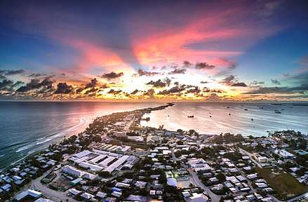
Majuro (/ˈmædʒəroʊ/; Marshallese: Mājro [mʲæzʲ(e)rˠo][2]) is the capital and largest city of the Marshall Islands. It is also a large coral atoll of 64 islands in the Pacific Ocean. It forms a legislative district of the Ratak (Sunrise) Chain of the Marshall Islands. The atoll has a land area of 9.7 square kilometres (3.7 sq mi) and encloses a lagoon of 295 square kilometres (114 sq mi). As with other atolls in the Marshall Islands, Majuro consists of narrow land masses.
Majuro | |
|---|---|
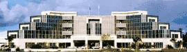 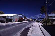   .jpg)   .jpg)  .jpg) .jpg)  Montage of Majuro | |
 Majuro Location of Majuro in Marshall Islands  Majuro Majuro (Pacific Ocean) .svg.png) Majuro Majuro (Earth) | |
| Coordinates: | |
| Country | |
| Island Chain | Ratak Chain |
| Founded | 1884 |
| Government | |
| • Mayor | Ladie Jack |
| Area | |
| • Total | 9.7 km2 (3.7 sq mi) |
| Population (2011) | |
| • Total | 27,797[1] |
| Time zone | UTC+12 (MHT) |
| Native languages | Marshallese |
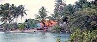
The main population center, Delap-Uliga-Djarrit (DUD), is made up of three contiguous motus and has a population of 20,301 people as of 2012. Majuro has a port, shopping district and hotels. Majuro has an international airport with scheduled international flights to Hawaii, Micronesia, Kiribati, and Nauru, and flights to domestic destinations around the country.
Geography
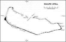
At the western end of the atoll, about 50 kilometres (30 mi) from D–U–D by road, is the island community of Laura, an expanding residential area with a popular beach.[3] Laura has the highest elevation point on the atoll, estimated at less than 3 metres (10 feet) above sea level.[4]
Djarrit is mostly residential.[5]
Climate
Being slightly north of the Equator, Majuro has a tropical rainforest climate but not an equatorial climate because trade winds are prevailing throughout the year though they are frequently interrupted during the summer months by the movement of the Intertropical Convergence Zone across the area [6]. Typhoons are rare. Temperatures are relatively consistent throughout the course of the year with average temperatures around 27 °C (81 °F). Very rarely does the temperature fall below 21 °C (70 °F).[5] Majuro sees roughly 3,200 millimetres (126 in) of precipitation annually.
| Climate data for Majuro | |||||||||||||
|---|---|---|---|---|---|---|---|---|---|---|---|---|---|
| Month | Jan | Feb | Mar | Apr | May | Jun | Jul | Aug | Sep | Oct | Nov | Dec | Year |
| Average high °F (°C) | 85.5 (29.7) |
85.9 (29.9) |
86.1 (30.1) |
86.1 (30.1) |
86.4 (30.2) |
86.3 (30.2) |
86.4 (30.2) |
86.7 (30.4) |
86.9 (30.5) |
86.9 (30.5) |
86.6 (30.3) |
85.9 (29.9) |
86.3 (30.2) |
| Average low °F (°C) | 77.8 (25.4) |
77.9 (25.5) |
78.0 (25.6) |
78.1 (25.6) |
78.3 (25.7) |
77.9 (25.5) |
77.8 (25.4) |
77.9 (25.5) |
77.9 (25.5) |
77.8 (25.4) |
77.9 (25.5) |
77.7 (25.4) |
77.9 (25.5) |
| Average precipitation inches (mm) | 8.28 (210) |
7.62 (194) |
7.55 (192) |
9.63 (245) |
9.86 (250) |
10.93 (278) |
11.93 (303) |
11.42 (290) |
12.14 (308) |
13.27 (337) |
13.23 (336) |
11.56 (294) |
127.42 (3,236) |
| Average precipitation days (≥ 0.01 in) | 19.3 | 16.1 | 17.6 | 18.9 | 22.1 | 23.1 | 24.3 | 22.9 | 22.9 | 23.4 | 22.9 | 22.7 | 256.2 |
| Average relative humidity (%) | 77.7 | 77.1 | 79.0 | 80.7 | 81.9 | 81.1 | 80.5 | 79.3 | 79.4 | 79.4 | 79.9 | 79.7 | 79.6 |
| Mean monthly sunshine hours | 224.4 | 218.6 | 252.8 | 219.4 | 224.8 | 210.8 | 217.0 | 232.2 | 217.8 | 205.4 | 191.4 | 197.4 | 2,612 |
| Percent possible sunshine | 61 | 66 | 67 | 60 | 58 | 56 | 56 | 61 | 60 | 55 | 54 | 54 | 59 |
| Source: NOAA (relative humidity and sun 1961−1990)[7][8] | |||||||||||||
History
Humans have inhabited the atoll for at least 2,000 years.[9]
Majuro Atoll was claimed by the German Empire with the rest of the Marshall Islands in 1884, and the Germans established a trading post. As with the rest of the Marshalls, Majuro was captured by the Imperial Japanese Navy in 1914 during World War I and mandated to the Empire of Japan by the League of Nations in 1920. The island then became a part of the Japanese mandated territory of the South Seas Mandate; although the Japanese had established a government in the Mandate, local affairs were mostly left in the hands of traditional local leaders until the start of World War II.

On January 30, 1944, United States troops invaded, but found that Japanese forces had evacuated their fortifications to Kwajalein and Enewetak about a year earlier. A single Japanese warrant officer had been left as a caretaker. With his capture, the islands were secured. This gave the U.S. Navy use of one of the largest anchorages in the Central Pacific. The lagoon became a large forward naval base of operations and was the largest and most active port in the world until the war moved westward when it was supplanted by Ulithi (Yap, Federated States of Micronesia).[10]
Following World War II, Majuro came under the control of the United States as part of the Trust Territory of the Pacific Islands. It supplanted Jaluit Atoll as the administrative center of the Marshall Islands, a status that it retains after the independence of the Marshall Islands in 1986.
Demographics
The major population centers are the D–U–D communities: the islets of Delap–Uliga–Djarrit (listed from south to north, on the eastern edge of the atoll). As of 2011, Majuro had a population of 27,797.[1]
Religion
Most of the population is Christian.[11] The majority follows the United Church of Christ. The Cathedral of the Assumption of the Roman Catholic Apostolic Prefecture of the Marshall Islands is located in Majuro.[12]
Islamic influence has been increasing. There is a sizable number of Ahmadi Muslims.[5] The first mosque opened in Majuro in September 2012.[13]
There are also LDS churches, Baptist churches, Seventh-Day Adventist churches, and the Salvation Army.[14]
Economy
Majuro's economy is driven by the service sector.[11]
On September 15, 2007, Witon Barry, of the Tobolar Copra processing plant in the Marshall Islands' capital of Majuro, said power authorities, private companies and entrepreneurs had been experimenting with coconut oil as an alternative to diesel fuel for vehicles, power generators and ships. Coconut trees abound in the Pacific's tropical islands. Copra from 6 to 10 coconuts makes 1 litre of oil.[15]
Air Marshall Islands has its headquarters in Majuro.[16]
Education and Finance
Colleges and universities
The College of the Marshall Islands is located in Uliga.
The University of South Pacific has a presence on Majuro.[11]
Bank of the Marshall Islands
Bank of Guam
Marshall Islands Development Bank
Beyond Banking Group
Primary and secondary schools
Marshall Islands Public School System operates public schools.
High schools:[17]
- The Marshall Islands High School is near the north end of Majuro.
- Laura High School
- Life Skills Academy
Primary schools:[18]
- Ajeltake Elementary School
- Delap Elementary School
- DUD Kindergarten
- Ejit Elementary School
- Laura Elementary School
- Long Island Elementary School
- Majuro Middle School
- Rairok Elementary School
- Rita Elementary School
- Uliga Elementary School
- Woja Maj. Elementary School
In the 1994–1995 school year Majuro had 10 private elementary schools and six private high schools.[19]
There is a Seventh Day Adventist High School and Elementary School in Delap, where English is taught to all students.[20]
Health
Majuro Hospital has 81 beds.[21] It is the main hospital for Majuro, as well as many of the outer islands; the only other major hospital is in Ebeye.[14]
Infrastructure
Water and sewage
The Majuro Water and Sewer Company obtains water from a catchment basin on the International Airport runway. It supplies 140,000,000 US gallons (530,000,000 l; 120,000,000 imp gal) a year or 14 US gallons (53 l; 12 imp gal) per person per day. This compares with New York City's 118 US gallons (450 l; 98 imp gal) per person per day. Water is supplied 12 hours daily. The threat of drought is commonplace.[22]
Transport
Air
Marshall Islands International Airport, offering domestic and international services, is on Majuro Atoll. It is served by four passenger airlines: United Airlines, Nauru Airlines, Air Marshall Islands, and Asia Pacific Airlines.[23]
Air Marshall Islands flies to most of the Marshalls' inhabited atolls once a week.[24] It offers daily service between Majuro and Kwajalein except Thursdays and Sundays.[25]
Sea
Majuro Lagoon is an active port. It is one of the busiest tuna transshipment ports in the world, with 306,796 tons of tuna being moved from purse seine vessels to carrier vessels in 2018.[26]
The Marshall Islands Shipping Corporation was established by the Marshall Islands via the Marshall Islands Shipping Corporation Act 2004.[27] It manages several government ships that move people and freight around the islands. These ships include three older ships (Langidrik, Aemman, and Ribuuk Ae), as well as two newer ships (Majuro, Kwajalein) which were donated to the Republic of the Marshall Islands by Japan in 2013.[28]. They also operate a landing craft (Jelejeletae). These vessels are the main link for transporting people and supplies to and from the outer islands.
Additionally, the lagoon acts as a harbor for commercial fishing vessels, cruise ships, sport fishing boats, outrigger canoes and the occasional luxury yacht.
Sport
Majuro was initially scheduled to host the seventh edition of the Micronesian Games, in 2010. It subsequently renounced its hosting rights, citing a lack of adequate infrastructure.[29][30]
There is an Olympic committee in Majuro. Weightlifter Mattie Langtor Sasser participated in the Rio 2016 Summer Olympics, competing in the Women's 58 kg category on August 8.[31] She was competing for the Marshall Islands.
Twin towns – sister cities
Majuro is twinned with:
References
- Republic of the Marshall Islands 2011 Census Report (PDF). Noumea: Secretariat of the Pacific Community. 2012. ISBN 978-982-00-0564-8.
- "M". trussel2.com. Retrieved 29 May 2015.
- A., Cybriwsky, Roman (2013-05-23). Capital cities around the world : an encyclopedia of geography, history, and culture. Santa Barbara, California. ISBN 9781610692489. OCLC 862077105.
- "One Meter Topobathymetric Digital Elevation Model for Majuro Atoll, Republic of the Marshall Islands, 1944 to 2016 - ScienceBase-Catalog". www.sciencebase.gov. Retrieved 2019-01-15.
- "V73XP - Majuro Atoll - Marshall Islands - News". dxnews.com. Retrieved 2019-01-15.
- "CHAPTER TWO—PACIFIC ISLANDS REGION" (PDF). www.eastwestcenter.org.
- "MH Majuro WBAS AP". National Oceanic and Atmospheric Administration. Retrieved 11 March 2015.
- "WMO climate normals for Majuro, PI 1961−1990". National Oceanic and Atmospheric Administration. Retrieved 11 March 2015.
- "The Natural history of Enewetak Atoll". Internet Archive. Oak Ridge, Tenn. : U.S. Dept. of Energy, Office of Energy Research, Office of Health and Environmental Research, Ecological Research Division. 1987. Retrieved 29 May 2015.
- "Eastern Mandates". army.mil. Retrieved 29 May 2015.
- "Marshall Islands". Office of Electronic Information, Bureau of Public Affairs. Retrieved 26 November 2011.
- "Cathedral of the Assumption". GCatholic.org. Retrieved 2013-01-15.
- First Mosque opens up in Marshall Islands by Radio New Zealand International, September 21, 2012
- "Marshall Islands" (PDF). www.imr.ptc.ac.fj.
- "Pacific Islands look to coconut power to fuel future growth". Archived from the original on 2008-01-13.
- "Contact Information Archived 2010-03-28 at the Wayback Machine." Air Marshall Islands. Retrieved on October 6, 2010. "Headquarters P.O. Box 1319 Majuro, MH 96960."
- "Secondary Schools Division Archived 2018-02-21 at the Wayback Machine." Marshall Islands Public School System. Retrieved on February 21, 2018.
- "Public Schools Archived 2018-02-21 at the Wayback Machine." Marshall Islands Public School System. Retrieved on February 21, 2018.
- McMurray, Christine and Roy Smith. Diseases of Globalization: Socioeconomic Transition and Health. Routledge, October 11, 2013. ISBN 1134200226, 9781134200221. p. 127.
- SSD Archived 2012-01-16 at the Wayback Machine
- "Health System Profile - Marshall Islands". cdc.gov. Archived from the original on 19 January 2015. Retrieved 29 May 2015.
- Peter Meligard (December 28, 2015). "Perishing of Thirst In A Pacific Paradise". Huffington Post. Retrieved August 3, 2016.
- "Airlines Serving the Marshall Islands - RMIPA". Republic of the Marshall Islands Ports Authority. Retrieved 29 May 2015.
- "Air Marshall Islands". airmarshallislands.com. Archived from the original on 18 January 2016. Retrieved 29 May 2015.
- Air Marshall Islands Archived 2013-09-02 at the Wayback Machine
- "Marshall Islands Marine Resources Authority Annual Report FY2018" (PDF). Marshall Islands Marine Resources Authority. p. 6. Archived from the original (PDF) on May 22, 2020. Retrieved May 22, 2020.
- "Marshall Islands Shipping Corporation Act 2004" (PDF). Nitijela: The Parliament of the Republic of the Marshall Islands. Archived from the original (PDF) on May 22, 2020. Retrieved May 22, 2020.
- "Government Ships". Marshall Islands Guide. Oct 12, 2015. Archived from the original on Nov 12, 2019. Retrieved May 22, 2020.
- "Scaled down Micro Games in 2010" Archived 2011-09-28 at the Wayback Machine, Jon Perez, Saipan Tribune, April 9, 2008
- "Two Northern Pacific countries vying for the right to host Micronesia Games". Radio New Zealand International. May 8, 2008. Retrieved October 19, 2011.
- "Mattie Sasser is lifted by Rio experience. - Marshall Islands National Olympic Committee". SportsTG. Retrieved 2016-10-31.
- "Taipei - International Sister Cities". Taipei City Council. Archived from the original on 2012-11-02. Retrieved 2013-08-23.
External links
| Wikimedia Commons has media related to Majuro. |
| Wikivoyage has a travel guide for Majuro. |
- Marshall Islands site
- Entry at Oceandots.com at the Wayback Machine (archived December 23, 2010)
- Recent photos of the rural portions of Majuro
- World War II photos of Majuro
- Battle of Kwajalein and Enewetak
Marshall Islands articles | |||||||
|---|---|---|---|---|---|---|---|
| History | |||||||
| Geography |
| ||||||
| Politics |
| ||||||
| Economy |
| ||||||
| Culture |
| ||||||
| |||||||