Avarua
Avarua (meaning "Two Harbours" in Cook Islands Māori) is a town and district in the north of the island of Rarotonga, and is the national capital of the Cook Islands.
Avarua | |
|---|---|
Town | |
 Ara Maire Nui, the main street in Avarua | |
_map.png) Location of Avarua (star) | |
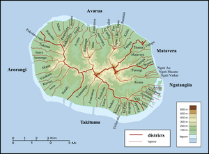 Districts and tapere of Rarotonga | |
| Coordinates: 21°12′25″S 159°46′15″W | |
| Country | Cook Islands |
| Island | Rarotonga |
| Population (2016) | |
| • Total | 4,906 |
| Time zone | UTC−10:00 (CKT) |
| Area code(s) | +682 |
| Climate | Af |
The town is served by Rarotonga International Airport (IATA Airport Code: RAR) and Avatiu Harbour.
The population of Avarua District is 4,906 (census of 2016).[1]
Sub-districts
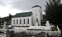 CICC church |
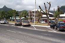 Main street of Avarua looking towards the Bank of the Cook Islands (BCI) building |
The town and district of Avarua is subdivided into 18 tapere (traditional sub-districts) out of 54 for Rarotonga, grouped into 6 Census Districts, listed from west to east. Census figures are not available on the tapere level, but only for the so-called Census Districts,[2] also listed from west to east:[3]
- Nikao-Panama (1,373 inhabitants), covering the taperes of:
- Pokoinu,
- Nikao (seat of Cook Islands parliament), and
- Puapuautu;
- Avatiu-Ruatonga (951 inhabitants), covering the taperes of:
- Areanu,
- Kaikaveka,
- Atupa,
- Avatiu (commercial port), and
- Ruatonga;
- Tutakimoa-Teotue (314 inhabitants), covering the tapere of:
- Tutakimoa;
- Takuvaine-Parekura (786 inhabitants), covering the taperes of:
- Tauae (inward from Tutakimoa, the only Tapere without a coastline)
- Takuvaine (downtown Avarua, seat of Cook Islands government, with Avarua fishing harbour)
- Tupapa-Maraerenga (531 inhabitants), covering the taperes of:
- Ngatipa, and
- Vaikai;
- Pue-Matavera (1,490 inhabitants), covering the taperes of:
- Tapae-I-Uta,
- Pue,
- Punamaia,
- Kiikii, and
- Tupapa.
Climate
Avarua has a tropical rainforest climate (Af) according to the Köppen climate classification with high temperatures and rainfall throughout the year.[4] Although there are no true wet or dry seasons, there is a noticeably wetter stretch from December to April.
| Climate data for Avarua | |||||||||||||
|---|---|---|---|---|---|---|---|---|---|---|---|---|---|
| Month | Jan | Feb | Mar | Apr | May | Jun | Jul | Aug | Sep | Oct | Nov | Dec | Year |
| Average high °C (°F) | 28.8 (83.8) |
29.1 (84.4) |
29.1 (84.4) |
28.3 (82.9) |
26.4 (79.5) |
25.3 (77.5) |
24.6 (76.3) |
24.9 (76.8) |
25.6 (78.1) |
26.3 (79.3) |
27.2 (81.0) |
28.0 (82.4) |
27.0 (80.5) |
| Daily mean °C (°F) | 25.9 (78.6) |
26.2 (79.2) |
26.2 (79.2) |
25.4 (77.7) |
23.7 (74.7) |
22.7 (72.9) |
22.0 (71.6) |
22.3 (72.1) |
22.7 (72.9) |
23.5 (74.3) |
24.4 (75.9) |
25.2 (77.4) |
24.2 (75.5) |
| Average low °C (°F) | 23.1 (73.6) |
23.4 (74.1) |
23.3 (73.9) |
22.5 (72.5) |
21.0 (69.8) |
20.1 (68.2) |
19.4 (66.9) |
19.7 (67.5) |
19.9 (67.8) |
20.7 (69.3) |
21.7 (71.1) |
22.4 (72.3) |
21.4 (70.6) |
| Average rainfall mm (inches) | 256 (10.1) |
229 (9.0) |
219 (8.6) |
246 (9.7) |
199 (7.8) |
128 (5.0) |
112 (4.4) |
141 (5.6) |
138 (5.4) |
121 (4.8) |
171 (6.7) |
246 (9.7) |
2,206 (86.8) |
| Source: Climate-Data.org | |||||||||||||
References
- Hassall, Graham; Tipu, Feue (28 April 2008). "Local Government in the South Pacific Islands". Commonwealth Journal of Local Governance (1): 7–29. doi:10.5130/cjlg.v1i0.766. Retrieved 2 May 2017 – via epress.lib.uts.edu.au.
- "Archived copy" (PDF). Archived from the original (PDF) on 2008-10-14. Retrieved 2008-08-29.CS1 maint: archived copy as title (link)
- P.H. Curson: "Population Change in the Cook Islands - The 1966 Population Census". In: New Zealand Geographer, Vol. 28, 1972, pp. 51-65, map p.52
- , Climate Avarua, Climate-Data.org
External links

- Photo of Government Radio Station Rarotonga c1950
| Northern | ||
|---|---|---|
| Southern - Nga-pu-Toru | ||
| Southern - other | ||
| Authority control |
|
|---|