South Tarawa
South Tarawa (in Gilbertese Tarawa Teinainano) is the capital and hub of the Republic of Kiribati and home to approximately half of Kiribati's population.[2] The South Tarawa population centre consists of all the small islets from Betio in the west to Bonriki and Tanaea in the east, connected by the South Tarawa main road, with a population of 50,182 as of 2010.[1]
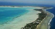 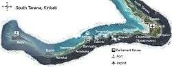 Top: South Tarawa Bird's Eye View Bottom: Map of South Tarawa | |
 | |
 South Tarawa Location in Kiribati | |
| Geography | |
|---|---|
| Location | Pacific Ocean |
| Coordinates | 1°26′N 173°00′E |
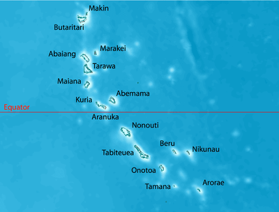
| Archipelago | Gilbert Islands |
| Area | 15.76 km2 (6.08 sq mi) |
| Highest elevation | 3 m (10 ft) |
| Administration | |
Kiribati | |
| Demographics | |
| Population | 50,182[1] (2010 Census) |
| Pop. density | 3,184/km2 (8,247/sq mi) |
| Ethnic groups | I-Kiribati 98.9% |
South Tarawa is home to most of the government, commercial and education facilities in Kiribati including the Port and the High Court at Betio, the State House, Government Ministries and foreign High Commissions in Bairiki, a University of the South Pacific campus in Teaorereke, the House of Assembly in Ambo, the Kiribati Teacher College and King George V and Elaine Bernachi School, the Government High School, is in Bikenibeu,[3] and the central hospital in Nawerewere. The Roman Catholic diocese is based in Teaorereke, the Kiribati Protestant Church (Congregational) in Antebuka, and The Church of Jesus Christ of Latter-day Saints in Eita.[4]
Administration
At the local government level, South Tarawa has two administrative subdivisions:
- Betio Town Council (or BTC) on Betio
- Teinainano Urban Council (or TUC) from Bairiki to Tanaea (the meaning of teinainano is "down of the mast", alluding to the sail-shape of the atoll)
Buota, which is part of North Tarawa and administered by the Eutan Tarawa Council (or ETC), is linked by road to South Tarawa and is experiencing many similar issues of rapid population growth, urbanisation and environmental degradation.
Geography
South Tarawa is a string of islets between the Tarawa Lagoon to the north, with a maximum depth of 25 metres (82 ft), and the Pacific Ocean to the south, with a depth of up to 4,000 metres (13,000 ft).[5] The island has been built from sediments from the lagoon.[6]
The process of soil accumulation is driven by the dominant easterly trade winds and can be reversed during extended periods of westerly winds during El Niño–Southern Oscillations.[7]
These islets are now joined by causeways, forming one long islet on the reef along the southern side of the Tarawa Lagoon. Most of South Tarawa is less than 3 metres (9.8 feet) above sea level with an average width of only 450 metres (1,480 feet).[4]
Population

At the time of the 1978 Census, South Tarawa had a population of 17,921 with most residents living in the main population centres of Betio, Bairiki and Bikenibeu. Since Kiribati became independent in 1979, the population of South Tarawa has almost tripled, and now stands at 50,182 people.[1] All of South Tarawa is now urbanised and is effectively one continuous settlement from the northeastern end of the island, Tanaea, to its southwestern end at Betio.
Buota in North Tarawa is connected to the South Tarawa main road and is also growing rapidly.
| South Tarawa: Places and population | |||
| Census area | 1978[8] | 2005[9] | 2010[1] |
|---|---|---|---|
| Tanaea | 27 | 91 | 279 |
| Bonriki | 635 | 2,119 | 2,355 |
| Temwaiku | – | 2,011 | 3,135 |
| Causeway (Nawerewere) | – | 1,780 | 2,054 |
| Bikenibeu | 3,971 | 6,170 | 6,568 |
| Abarao | 322 | 908 | 1,665 |
| Eita | 612 | 2,299 | 3,061 |
| Tangintebu | 128 | 94 | 89 |
| Taborio | 187 | 955 | 1,282 |
| Ambo | – | 1,688 | 2,200 |
| Banraeaba | 501 | 1,789 | 1,969 |
| Antebuka | 504 | 390 | 1,087 |
| Teaoraereke | 848 | 3,939 | 4,171 |
| Nanikai | 604 | 803 | 988 |
| Bairiki | 1,956 | 2,766 | 3,524 |
| Betio | 7,626 | 12,509 | 15,755 |
| South Tarawa total | 17,921 | 40,311 | 50,182 |
History
Tarawa island is central to Kiribati mythology and culture, but life on South Tarawa was little different to that on other islands before it was selected as the seat of colonial government for the Protectorate of the Gilbert and Ellice Islands.
Betio was the location of the Battle of Tarawa.
Environment
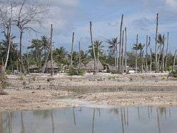
The highest point on South Tarawa is only a few meters above sea level, making the island extremely vulnerable to climate change and natural disasters. The effects of rising sea levels and associated soil salination are starting to threaten limited fresh water supplies.[10]
Climate
The weather in South Tarawa is warm and humid all year round and average rainfalls are relatively high. However, rainfall is very unpredictable, varying with the El Niño–Southern Oscillation, and South Tarawa can go for many months with almost no rain during La Niña cycles.
| Climate data for Tarawa Airport (South Tarawa) | |||||||||||||
|---|---|---|---|---|---|---|---|---|---|---|---|---|---|
| Month | Jan | Feb | Mar | Apr | May | Jun | Jul | Aug | Sep | Oct | Nov | Dec | Year |
| Record high °C (°F) | 35.0 (95.0) |
33.0 (91.4) |
35.0 (95.0) |
34.5 (94.1) |
34.5 (94.1) |
33.5 (92.3) |
34.5 (94.1) |
34.5 (94.1) |
34.5 (94.1) |
35.0 (95.0) |
35.0 (95.0) |
35.0 (95.0) |
35.0 (95.0) |
| Average high °C (°F) | 30.7 (87.3) |
30.6 (87.1) |
30.7 (87.3) |
30.7 (87.3) |
30.8 (87.4) |
30.8 (87.4) |
30.9 (87.6) |
31.0 (87.8) |
31.1 (88.0) |
31.2 (88.2) |
31.3 (88.3) |
30.9 (87.6) |
30.9 (87.6) |
| Daily mean °C (°F) | 28.2 (82.8) |
28.1 (82.6) |
28.1 (82.6) |
28.2 (82.8) |
28.4 (83.1) |
28.3 (82.9) |
28.2 (82.8) |
28.3 (82.9) |
28.4 (83.1) |
28.6 (83.5) |
28.5 (83.3) |
28.2 (82.8) |
28.3 (82.9) |
| Average low °C (°F) | 25.3 (77.5) |
25.3 (77.5) |
25.2 (77.4) |
25.3 (77.5) |
25.5 (77.9) |
25.3 (77.5) |
25.1 (77.2) |
25.2 (77.4) |
25.3 (77.5) |
25.4 (77.7) |
25.4 (77.7) |
25.3 (77.5) |
25.3 (77.5) |
| Record low °C (°F) | 21.5 (70.7) |
22.5 (72.5) |
22.5 (72.5) |
22.5 (72.5) |
21.0 (69.8) |
21.0 (69.8) |
21.0 (69.8) |
21.5 (70.7) |
22.5 (72.5) |
22.0 (71.6) |
22.5 (72.5) |
22.0 (71.6) |
21.0 (69.8) |
| Average precipitation mm (inches) | 271 (10.7) |
218 (8.6) |
204 (8.0) |
184 (7.2) |
158 (6.2) |
155 (6.1) |
168 (6.6) |
138 (5.4) |
120 (4.7) |
110 (4.3) |
115 (4.5) |
212 (8.3) |
2,052 (80.8) |
| Average precipitation days (≥ 0.3 mm) | 15 | 12 | 14 | 15 | 15 | 14 | 16 | 18 | 15 | 11 | 10 | 17 | 172 |
| Average relative humidity (%) | 81 | 80 | 81 | 82 | 81 | 81 | 80 | 79 | 77 | 77 | 79 | 81 | 80 |
| Mean monthly sunshine hours | 220.1 | 192.1 | 207.7 | 201.0 | 229.4 | 219.0 | 229.4 | 257.3 | 243.0 | 260.4 | 240.0 | 189.1 | 2,688.5 |
| Mean daily sunshine hours | 7.1 | 6.8 | 6.7 | 6.7 | 7.4 | 7.3 | 7.4 | 8.3 | 8.1 | 8.4 | 8.0 | 6.1 | 7.4 |
| Source: Deutscher Wetterdienst[11] | |||||||||||||
Water
South Tarawa has very limited water resources for its rapidly growing population. During the frequent droughts, the only source of water is the shallow freshwater lens that permeates the coral rock of the atoll. The water lenses at Bonriki and Buota have been declared as water reserves, and have a combined sustainable yield of 1,300 m3 per day.
Other previously declared water reserves have been relinquished for urbanisation or abandoned due to overpumping and pollution from human settlement.[12]
Water from the Bonriki and Buota reserves is distributed by a reticulated network to South Tarawa households. However, the poor condition of the network and the limited water supply mean that water can only be supplied to each village for around 2 hours every two days. Most schools and community buildings have no water supply at all, and many households rely on polluted groundwater due to the shortage of treated water.[13]
Because of the shortage of fresh water, sanitation systems must use saltwater for flushing. The sanitation network on South Tarawa is performing very poorly, and a major project is underway to rehabilitate the system and improve sanitation and public hygiene.[14]
Coastal erosion
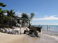
The Ministry of Environment, Lands and Agriculture Development (MELAD) is involved in the replanting of mangroves in selected sites to help against coastal erosion; however, much more is required to protect many of the sites eroded on South Tarawa including islets that once were protected with mangrove and iron-wood (tengea) trees. It is unclear how much of the erosion being experienced on South Tarawa is due to sea-level rise and how much is due to human activities (such as building inappropriate seawalls and mining sand and gravel from the beaches and foreshores. Coastal erosion will accelerate in future, due to climate change related sea level rise.[4]
Land availability and overcrowding
The land area of South Tarawa is officially recorded as 3,896 acres (1,577 ha) or 15.76 square km.
Much of this land is not available for use, including the water reserve and runway, the causeways, and a large area of reclaimed land at Temwaiku, the eastern corner of the atoll, which is too swampy and low-lying. If these areas are excluded, the land area of South Tarawa is only just over 1,000 hectares (10 square km or 2,500 acres) and the population density of 49 people per hectare or 4,905 per square km is almost equal to the density of London (5,100 people per km2) and twice the density of Sydney, Auckland, or New York.[15]
Multi-storey buildings are very uncommon on South Tarawa. The high population is accommodated through large household sizes, with an average of 7.3 people per household, on small land plots. Most land is owned by the original families or kain Tarawa, although in the main centres of Betio, Bairiki and Bikenibeu there are large areas of land on long-term lease to the government. Without access to family lands or government housing, many South Tarawa residents have no choice but to become squatters; disputes over land are common.
South Tarawa and especially Betio have high rates of respiratory infections, diarrhoea, and dysentery,[4] all of which have been linked to overcrowding.[16] Unsustainable development in South Tarawa is a concern to the government and to Kiribati's aid partners.[17] Anote Tong's administration aims to ease the problem in the country's main urban centre by encouraging people to stay and to resettle in outer islands. It has invested in facilities such as the South Kiribati Hospital to spread institutions and services out around the islands and relieve South Tarawa from overcrowding.[18]
| South Tarawa: Population and Land Area | ||||
| Census Area | Population 2010[1] | Land area available[1] | Land area, not available for residential, commercial or government use[1] | Density, people per hectare |
|---|---|---|---|---|
| Tanaea | 279 | 9 hectares (22 acres) | - | 31 |
| Bonriki | 2355 | 70 hectares (173 acres) | 139 hectares (343 acres)1 | 34 |
| Temwaiku | 3135 | 161 hectares (398 acres) | 383 hectares (946 acres)2 | 19 |
| Causeway/Nawerewere | 2054 | |||
| Bikenibeu | 6568 | 181 hectares (447 acres) | - | 36 |
| Abarao | 1665 | 58 hectares (143 acres) | - | 29 |
| Eita | 3061 | 104 hectares (257 acres) | 9 hectares (22 acres)3 | 29 |
| Tangintebu | 89 | |||
| Taborio | 1282 | |||
| Ambo | 2200 | 141 hectares (348 acres) | - | 16 |
| Banraeaba | 1969 | |||
| Antebuka | 1087 | |||
| Teaoraereke | 4171 | 87 hectares (215 acres) | 4.2 hectares (10 acres)4 | 48 |
| Nanikai | 988 | 12 hectares (30 acres) | - | 82 |
| Bairiki | 3524 | 46 hectares (114 acres) | 5.0 hectares (12 acres)5 | 77 |
| Betio-Bairiki causeway | not included | |||
| Betio | 15755 | 154 hectares (381 acres) | 13.7 hectares (34 acres)6 | 102 |
| South Tarawa total | 50182 | 1,023 hectares (2,528 acres) | 553 hectares (1,366 acres) | 49 |
Reasons land not available for use:
- Bonriki; Water reserve, airport
- Temwaiku; Reclamation and fish ponds
- Eita/Taborio; Abairarang (scout) Is. Abaokoro (Guide) Is. and Taborio Causeway
- Teaoraereke; Causeway
- Naanekai-Bairiki causeway, Bairiki wharf and jetty
- Betio; Sandspit, wharves, jetties
Economy

South Tarawa is the economic hub of Kiribati, the location of the main port and airport and of most of the state-owned enterprises and private businesses.

Copra produced on the outer islands is processed on Betio, producing copra oil for the international market and other products which are sold locally. There is a fish processing plant producing tuna for export.
Imports far outweigh exports, and most households on South Tarawa rely on government employment and remittances from relatives working overseas. Unemployment and underemployment are a serious problem; in 2010 only 34% of urban adults (over 15) were engaged in cash work; the remaining two-thirds are either out of the labour force, unemployed or engaged in subsistence activities. Young people are especially likely to be unemployed.
Education
Currently there is one government high school, King George V and Elaine Bernacchi School in Bikenibeu. There are also several private Christian high schools:[19]
- Church of God High School
- Moroni High School - Also has junior high school
- Sacred Heart High School
- St. Louis High School
- William Goward Memorial School
Visiting
Transport
Fiji Airways flies to Bonriki International Airport on South Tarawa from Nadi on Mondays and Thursdays.
Accommodation
There is a range of accommodation available for visitors and for those working short term in South Tarawa. Details are available from Tourism Kiribati.[20]
See also
References
- "Kiribati Census Report 2010 Volume 1" (PDF). National Statistics Office, Ministry of Finance and Economic Development, Government of Kiribati. Archived from the original (PDF) on 10 August 2014. Retrieved 17 March 2013.
- Country files at earth-info.nga.mil Archived 12 August 2005 at the Wayback Machine
- "6. South Tarawa" (PDF). Office of Te Beretitent – Republic of Kiribati Island Report Series. 2012. Retrieved 28 April 2015.
- "South Tarawa Island Report". Government of Kiribati.
- Martin 2000, p. 152.
- Schofield 1977, p. 533.
- Chaoxiong 2001, p. 6.
- Report of the 1978 Census of population and housing. Republic of Kiribati 1980, Vol. 1, S. 6–7
- Kiribati 2005 census of population and housing.
- "Kiribati Country Assistance Strategy (Press Release)". World Bank.
- "Klimatafel von Tarawa, Int. Flugh. Bonriki / Kiribati (Gilbert-Inseln)" (PDF). Baseline climate means (1961–1990) from stations all over the world (in German). Deutscher Wetterdienst. Archived from the original (PDF) on 29 September 2019. Retrieved 29 September 2019.
- Metai, Eita. "Vulnerability of Freshwater Lens on Tarawa – The Role of Hydrological Monitoring in Determining Sustainable Yield" (PDF). Proceedings of the Pacific Regional Consultation on Water in Small Island Countries Theme 2 Case Studies – 65.
- "Kiribati Social and Economic Report". Asian Development Bank.
- "ADB and Australia to Help Kiribati Improve Sanitation, Public Hygiene (Press Release)". Asian Development Bank.
- "Largest cities in the world ranked by population density". City Mayors.
- "Kiribati health information profile". World Health Organization – Western Pacific Ocean. World Health Organization. Archived from the original on 8 June 2011. Retrieved 9 June 2011.
- "Kiribati profile on New Zealand's Ministry of Foreign Affairs and Trade official Site". New Zealand's Ministry of Foreign Affairs and Trade. Retrieved 9 June 2011.
- Pareti, Samisoni. "Politics: Easing congestion and overcrowding". Island Business. Islands Business International. Archived from the original on 23 March 2012. Retrieved 9 June 2011.
- "TABITEUEA NORTH 2008 Socio-Economic Profile" Part 2 of 4. Strengthening Decentralized Governance in Kiribati Project , Ministry of Internal and Social Affairs (Kiribati). p. 48 (PDF p. 13/15). Part 1 is here.
- "Tarawa Accommodation Overview". Tourism Kiribati. Archived from the original on 20 March 2013. Retrieved 15 March 2013.
External links

| Gilbert Islands |  | |
|---|---|---|
| Phoenix Islands | ||
| Line Islands | ||
| West of Gilberts | ||
| Reefs | ||
| ||