Ailuk Atoll
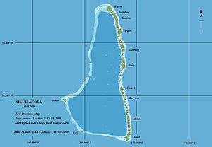
Ailuk Atoll (Marshallese: Aelok, [ɑelʲokʷ][1]) is a coral atoll of 57 islets in the Pacific Ocean, and forms a legislative district of the Ratak Chain of the Marshall Islands. It is located approximately 72 kilometres (45 mi) north from Wotje. Its total land area is only 5.4 square kilometres (2.1 sq mi), but it encloses a lagoon with an area of 177.45 square kilometres (68.51 sq mi). The major islets are: Ajelep, Aliej, Ailuk, Alkilwe, Barorkan, Biken, Enejabrok, Enejelar, Kapen and Marib. Most of the islets are on the eastern side of the atoll. The western and southern sides of the atoll have a nearly continuous submerged coral reef, with three main passes that lead into the lagoon: Erappu Channel, Marok Channel and Eneneman Channel on the west side.
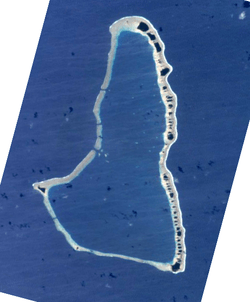 NASA picture of Ailuk Atoll | |
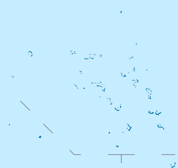 Ailuk Atoll Location in the Marshall Islands | |
| Geography | |
|---|---|
| Location | North Pacific |
| Coordinates | 10°19′40″N 169°56′00″E |
| Archipelago | Ratak |
| Total islands | 57 |
| Area | 5.4 km2 (2.1 sq mi) |
| Highest elevation | 3 m (10 ft) |
| Administration | |
| Demographics | |
| Population | 339 (2011) |
| Ethnic groups | Marshallese |
Ailuk Atoll had a population of 339 in 2011.[2]
History
First recorded sighting of Ailuk Atoll by Europeans was by the Spanish expedition of Miguel López de Legazpi on 10 January 1565. It was charted as Los Placeres (The Pleasures in Spanish).[3][4] Two of its islets were charted as San Pedro and San Pablo, those being the names of the flagship ("capitana") and the "almiranta" (secondary ship or ship of the Admiral)[5]
Ailuk Atoll was claimed by the Empire of Germany along with the rest of the Marshall Islands in 1884, and the Germans established a trading outpost. After World War I, the island came under the South Pacific Mandate of the Empire of Japan. Following the end of World War II, it came under the control of the United States as part of the Trust Territory of the Pacific Islands until the independence of the Marshall Islands in 1986.
Education
Marshall Islands Public School System operates public schools:[6]
- Ailuk Elementary School
- Enejelar Elementary School
Northern Islands High School on Wotje serves the community.[7]
References
- Marshallese-English Dictionary - Place Name Index
- https://www.doi.gov/sites/doi.gov/files/migrated/oia/reports/upload/RMI-2011-Census-Summary-Report-on-Population-and-Housing.pdf
- Sharp, Andrew The discovery of the Pacific Islands Oxford, 1960, p.38.
- Brand, Donald D. The Pacific Basin: A History of its Geographical Explorations The American Geographical Society, New York, 1967, p.129.
- Coello, Francisco "Conflicto hispano-alemán" Boletín de Sociedad Geográfica de Madrid, t.XIX. 2º semestre 1885, Madrid, p.286
- "Public Schools Archived 2018-02-21 at the Wayback Machine." Marshall Islands Public School System. Retrieved on February 21, 2018.
- "Annual Report 2011-2012." Ministry of Education (Marshall Islands). Retrieved on February 22, 2018. p. 54 (PDF p. 55/118). "Northern Islands High School takes students from the Ratak Ean zone including schools in Aur, Maloelap, Wotje, Ailuk, Utrik, Likiep and Mejit."
- Marshall Islands site
- "Oceandots entry for Ailuk". Archived from the original on December 23, 2010. Retrieved July 31, 2010.CS1 maint: BOT: original-url status unknown (link)
| Wikimedia Commons has media related to Ailuk Atoll. |
Marshall Islands articles | |||||||
|---|---|---|---|---|---|---|---|
| History | |||||||
| Geography |
| ||||||
| Politics |
| ||||||
| Economy |
| ||||||
| Culture |
| ||||||
| |||||||