List of the major 4000-meter summits of the Rocky Mountains
The following sortable table comprises the 62 peaks of the Rocky Mountains of North America with at least 4000 meters (13,123 feet) of elevation and at least 500 meters (1640 feet) of topographic prominence.[1]
The summit of a mountain or hill may be measured in three principal ways:
- The topographic elevation of a summit measures the height of the summit above a geodetic sea level.[2][3]
- The topographic prominence of a summit is a measure of how high the summit rises above its surroundings.[4][3]
- The topographic isolation (or radius of dominance) of a summit measures how far the summit lies from its nearest point of equal elevation.[5]
In the Rocky Mountains, the following 62 major summits exceed 4000 meters (13,123 feet) elevation, 137 exceed 3500 meters (11,483 feet), and 184 exceed 3000 meters (9843 feet) elevation.
Major 4000-meter summits
Of the 124 major 4000-meter summits of greater North America, the following 62 (or 50%) are in the Rocky Mountains.
Of these 62 major 4000-meter summits of the Rocky Mountains, 55 are located in Colorado, five in Wyoming, and one each in Utah and New Mexico. The 30 highest major summits of the Rocky Mountains are all located in Colorado.
Gallery
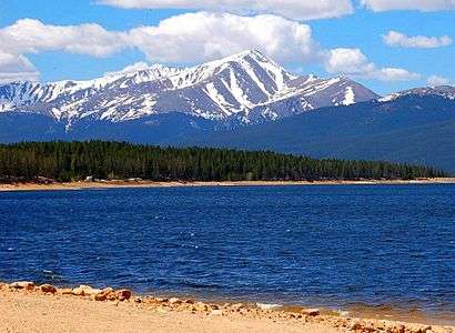
- 1. Mount Elbert in the Sawatch Range is the highest summit of the Rocky Mountains and the U.S. State of Colorado.
 2. Mount Massive in the Sawatch Range of Colorado is the second highest summit of the Rocky Mountains.
_-_2006-07-16.jpg) 3. Mount Harvard is the highest summit of the Collegiate Peaks of Colorado.
3. Mount Harvard is the highest summit of the Collegiate Peaks of Colorado.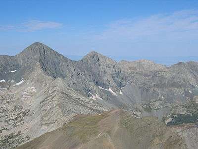 4. Blanca Peak is the highest summit of the Sangre de Cristo Mountains of Colorado.
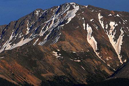 5. La Plata Peak in the Collegiate Peaks of Colorado is the fifth highest summit of the Rocky Mountains.
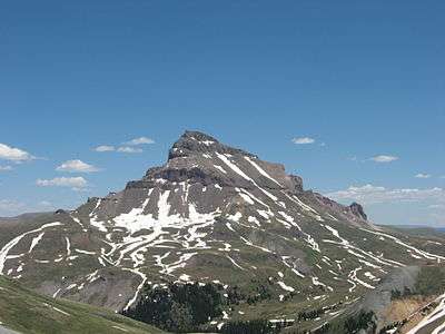 6. Uncompahgre Peak is the highest summit of the San Juan Mountains of Colorado.
 7. Crestone Peak is the highest summit of the Crestones of Colorado.
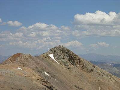 8. Mount Lincoln is the highest summit of the Mosquito Range of Colorado.
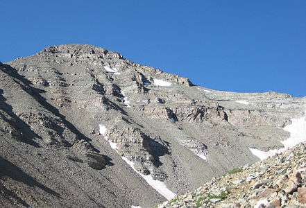 9. Castle Peak is the highest summit of the Elk Mountains of Colorado.
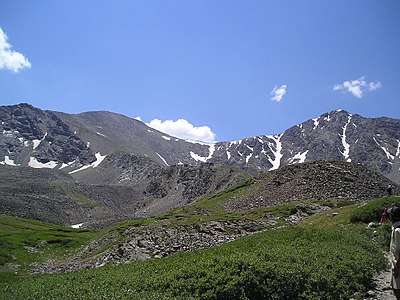 10. Grays Peak is the highest summit of the Front Range of Colorado and the highest point on the Continental Divide in North America.
 13. Longs Peak is the highest peak of the northern Front Range of Colorado.
 20. Pikes Peak in Colorado was the inspiration for America the Beautiful.
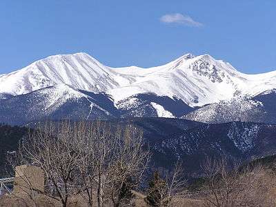 23. Culebra Peak in Colorado is the highest summit of the Culebra Range.
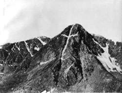 25. This photograph of the legendary Mount of the Holy Cross in Colorado was taken by William Henry Jackson in 1874.
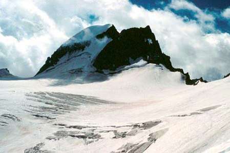 31. Gannett Peak is the highest summit of the Wind River Range, the U.S. State of Wyoming, and the Central Rocky Mountains.
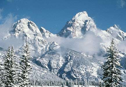 32. Grand Teton is the highest summit of the Teton Range of Wyoming.
 42. Kings Peak (at right) is the highest summit of the Uinta Mountains, the U.S. State of Utah, and the Western Rocky Mountains.
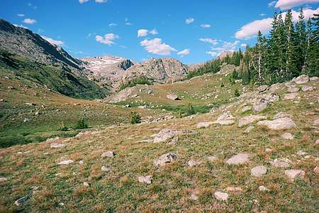 58. Cloud Peak is the highest summit of the Big Horn Mountains of Wyoming.
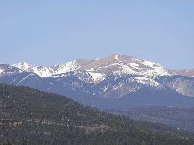 58. Wheeler Peak in the Sangre de Cristo Mountains is the highest point of the U.S. State of New Mexico.
See also
- Rocky Mountains
- Geology of the Rocky Mountains
- Category:Rocky Mountains
- Geology of the Rocky Mountains
- List of mountain peaks of North America
- List of mountain peaks of Greenland
- List of mountain peaks of Canada
- List of mountain peaks of the Rocky Mountains
- List of the major 4000-meter summits of the Rocky Mountains
- List of the major 3000-meter summits of the Rocky Mountains
- List of the ultra-prominent summits of the Rocky Mountains
- List of the major 100-kilometer summits of the Rocky Mountains
- List of extreme summits of the Rocky Mountains
- List of mountain peaks of the United States
- List of mountain peaks of México
- List of mountain peaks of Central America
- List of mountain peaks of the Caribbean
- Physical geography
Notes
- The summit of Mount Elbert is the highest point of the U.S. State of Colorado, the Rocky Mountains of North America, and the entire Mississippi River drainage basin.
- Mount Massive is the second highest major summit of the Rocky Mountains.
- The elevation of Mount Massive includes an adjustment of +2.087 m (6.85 ft) from NGVD 29 to NAVD 88.
- The summit of Mount Harvard is the highest point of the Collegiate Peaks.
- Mount Harvard is the southernmost and easternmost summit of its elevation in the Rocky Mountains.
- The summit of Blanca Peak is the highest point of the Sangre de Cristo Mountains and the entire Rio Grande drainage basin.
- Blanca Peak is the southernmost ultra-prominent summit of the Rocky Mountains.
- The elevation of Blanca Peak includes an adjustment of +1.755 m (5.76 ft) from NGVD 29 to NAVD 88.
- The elevation of La Plata Peak includes an adjustment of +1.983 m (6.51 ft) from NGVD 29 to NAVD 88.
- The summit of Uncompahgre Peak is the highest point of the San Juan Mountains and the entire Gulf of California drainage basin.
- Uncompahgre Peak is the westernmost summit of its elevation in the Rocky Mountains.
- The summit of Crestone Peak is the highest point of the Crestones.
- The elevation of Crestone Peak includes an adjustment of +1.76 m (5.77 ft) from NGVD 29 to NAVD 88.
- The summit of Mount Lincoln is the highest point of the Mosquito Range and the entire Missouri River drainage basin.
- Mount Lincoln is the northernmost summit of its elevation in the Rocky Mountains.
- The summit of Castle Peak is the highest point of the Elk Mountains.
- The summit of Grays Peak is the highest point of the Front Range and the Continental Divide in North America.
- Grays Peak is the northernmost summit of its elevation in the Rocky Mountains.
- The summit of Mount Antero is the highest point of the southern Sawatch Range.
- The summit elevation of Mount Evans includes a vertical offset of +1.798 m (5.9 ft) from the station benchmark.
- The summit of Longs Peak is the highest point of the northern Front Range.
- Longs Peak is the northernmost 14,000-foot (4267-meter) summit of the Rocky Mountains.
- The summit of Mount Wilson is the highest point of the San Miguel Mountains.
- Mount Wilson is the westernmost summit of its elevation in the Rocky Mountains.
- The elevation of Mount Wilson includes an adjustment of +1.899 m (6.23 ft) from NGVD 29 to NAVD 88.
- The summit of Mount Sneffels is the highest point of the Sneffels Range.
- The elevation of Capitol Peak includes an adjustment of +1.991 m (6.53 ft) from NGVD 29 to NAVD 88.
- Pikes Peak is the easternmost 14,000-foot (4267-meter) summit and ultra-prominent summit of the Rocky Mountains. Pikes Peak was the inspiration for the lyrics of America the Beautiful.
- The summit of Windom Peak is the highest point of the Needle Mountains.
- Mount Eolus may be higher than Windom Peak.
- The elevation of Windom Peak includes an adjustment of +1.785 m (5.86 ft) from NGVD 29 to NAVD 88.
- The summit of Culebra Peak is the highest point of the Culebra Range.
- Culebra Peak is the southernmost 14,000-foot (4267-meter) summit of the Rocky Mountains.
- The elevation of Culebra Peak includes an adjustment of +1.74 m (5.71 ft) from NGVD 29 to NAVD 88.
- The summit of San Luis Peak is the highest point of the La Garita Mountains.
- The summit of Mount of the Holy Cross is the highest point of the northern Sawatch Range.
- The summit elevation of Mount of the Holy Cross includes a vertical offset of +0.61 m (2 ft) from the station benchmark.
- The summit of Mount Ouray is the highest point of the far southern Sawatch Range.
- The elevation of Vermilion Peak includes an adjustment of +1.827 m (5.99 ft) from NGVD 29 to NAVD 88.
- The summit of Gannett Peak is the highest point of the Wind River Range, the U.S. State of Wyoming, and the central Rocky Mountains.
- Gannett Peak is the northernmost and westernmost summit of its elevation in the Rocky Mountains.
- The summit of Grand Teton is the highest point of the Teton Range.
- Grand Teton is the northernmost and westernmost 4000-meter (13,123-foot) summit of the Rocky Mountains.
- The elevation of Bald Mountain includes an adjustment of +1.922 m (6.31 ft) from NGVD 29 to NAVD 88.
- The elevation of Mount Oso includes an adjustment of +1.776 m (5.83 ft) from NGVD 29 to NAVD 88.
- The elevation of Bard Peak includes an adjustment of +1.707 m (5.6 ft) from NGVD 29 to NAVD 88.
- West Spanish Peak is the easternmost 4000-meter (13,123-foot) summit of the Rocky Mountains and the United States.
- The elevation of West Spanish Peak includes an adjustment of +1.468 m (4.82 ft) from NGVD 29 to NAVD 88.
- The summit of Mount Powell is the highest point of the Gore Range.
- The elevation of Mount Powell includes an adjustment of +1.771 m (5.81 ft) from NGVD 29 to NAVD 88.
- The summit of Hagues Peak is the highest point of the Mummy Range.
- The elevation of Tower Mountain includes an adjustment of +1.796 m (5.89 ft) from NGVD 29 to NAVD 88.
- The elevation of Treasure Mountain includes an adjustment of +2.008 m (6.59 ft) from NGVD 29 to NAVD 88.
- The summit of Kings Peak is the highest point of the Uinta Mountains, the U.S. State of Utah, and the western Rocky Mountains.
- The elevation of Kings Peak includes an adjustment of +1.807 m (5.93 ft) from NGVD 29 to NAVD 88.
- The summit of North Arapaho Peak is the highest point of the Indian Peaks.
- The elevation of North Arapaho Peak includes an adjustment of +1.763 m (5.78 ft) from NGVD 29 to NAVD 88.
- The elevation of Parry Peak includes an adjustment of +1.763 m (5.78 ft) from NGVD 29 to NAVD 88.
- The summit of Bill Williams Peak is the highest point of the Williams Mountains.
- The elevation of Bill Williams Peak includes an adjustment of +2.044 m (6.71 ft) from NGVD 29 to NAVD 88.
- The elevation of Sultan Mountain includes an adjustment of +1.649 m (5.41 ft) from NGVD 29 to NAVD 88.
- The elevation of Mount Herard includes an adjustment of +1.64 m (5.38 ft) from NGVD 29 to NAVD 88.
- The elevation of West Buffalo Peak includes an adjustment of +1.834 m (6.02 ft) from NGVD 29 to NAVD 88.
- The summit of Summit Peak is the highest point of the southern San Juan Mountains.
- Dolores Peak may be higher than Middle Peak.
- The elevation of Middle Peak includes an adjustment of +1.809 m (5.94 ft) from NGVD 29 to NAVD 88.
- The elevation of Antora Peak includes an adjustment of +1.883 m (6.18 ft) from NGVD 29 to NAVD 88.
- The elevation of Henry Mountain includes an adjustment of +2.037 m (6.68 ft) from NGVD 29 to NAVD 88.
- The summit of Hesperus Mountain is the highest point of the La Plata Mountains.
- The elevation of Hesperus Mountain includes an adjustment of +1.65 m (5.41 ft) from NGVD 29 to NAVD 88.
- The elevation of Jacque Peak includes an adjustment of +1.866 m (6.12 ft) from NGVD 29 to NAVD 88.
- The elevation of Bennett Peak includes an adjustment of +1.782 m (5.85 ft) from NGVD 29 to NAVD 88.
- The summit of Wind River Peak is the highest point of the southern Wind River Range.
- The summit of Cloud Peak is the highest point of the Bighorn Mountains.
- Cloud Peak is the northernmost 4000-meter (13,123-foot) summit of the Rocky Mountains.
- The summit of Wheeler Peak is the highest point of the Taos Mountains and the U.S. State of New Mexico.
- Wheeler Peak is the southernmost 4000-meter (13,123-foot) summit of the Rocky Mountains.
- The summit of Francs Peak is the highest point of the Absaroka Range.
- The summit of Twilight Peak is the highest point of the West Needle Mountains.
- The elevation of Twilight Peak includes an adjustment of +1.537 m (5.04 ft) from NGVD 29 to NAVD 88.
References
- This article defines a significant summit as a summit with at least 100 meters (328.1 feet) of topographic prominence, and a major summit as a summit with at least 500 meters (1640 feet) of topographic prominence. All summits in this article have at least 500 meters of topographic prominence. An ultra-prominent summit is a summit with at least 1500 meters (4921 feet) of topographic prominence.
- All elevations in the 48 states of the contiguous United States include an elevation adjustment from the National Geodetic Vertical Datum of 1929 (NGVD 29) to the North American Vertical Datum of 1988 (NAVD 88). For further information, please see this United States National Geodetic Survey note.
- If the elevation or prominence of a summit is calculated as a range of values, the arithmetic mean is shown.
- The topographic prominence of a summit is the topographic elevation difference between the summit and its highest or key col to a higher summit. The summit may be near its key col or quite far away. The key col for Denali in Alaska is the Isthmus of Rivas in Nicaragua, 7642 kilometers (4749 miles) away.
- The topographic isolation of a summit is the great-circle distance to its nearest point of equal elevation.
- "MOUNT ELBERT". Datasheet for NGS Station KL0637. U.S. National Geodetic Survey. Retrieved 4 May 2016.
- "Mount Elbert". Peakbagger.com. Retrieved 4 May 2016.
- "Mount Elbert". Bivouac.com. Retrieved 4 May 2016.
- "MOUNT MASSIVE CAIRN". Datasheet for NGS Station KL0640. U.S. National Geodetic Survey. Retrieved 4 May 2016.
- "Mount Massive". Peakbagger.com. Retrieved 4 May 2016.
- "Mount Massive". Bivouac.com. Retrieved 4 May 2016.
- "HARVARD". Datasheet for NGS Station JL0879. U.S. National Geodetic Survey. Retrieved 4 May 2016.
- "Mount Harvard". Peakbagger.com. Retrieved 4 May 2016.
- "Mount Harvard". Bivouac.com. Retrieved 4 May 2016.
- "Blanca Peak". Peakbagger.com. Retrieved 4 May 2016.
- "Blanca Peak". Bivouac.com. Retrieved 4 May 2016.
- "La Plata Peak". Peakbagger.com. Retrieved 4 May 2016.
- "La Plata Peak". Bivouac.com. Retrieved 4 May 2016.
- "UNCOMPAHGRE". Datasheet for NGS Station JL0798. U.S. National Geodetic Survey. Retrieved 4 May 2016.
- "Uncompahgre Peak". Peakbagger.com. Retrieved 4 May 2016.
- "Uncompahgre Peak". Bivouac.com. Retrieved 4 May 2016.
- "Crestone Peak". Peakbagger.com. Retrieved 4 May 2016.
- "Crestone Peak". Bivouac.com. Retrieved 4 May 2016.
- "MT LINCOLN". Datasheet for NGS Station KL0627. U.S. National Geodetic Survey. Retrieved 4 May 2016.
- "Mount Lincoln". Peakbagger.com. Retrieved 4 May 2016.
- "Mount Lincoln". Bivouac.com. Retrieved 4 May 2016.
- "CASTLE PK". Datasheet for NGS Station KL0659. U.S. National Geodetic Survey. Retrieved 4 May 2016.
- "Castle Peak". Peakbagger.com. Retrieved 4 May 2016.
- "Castle Peak". Bivouac.com. Retrieved 4 May 2016.
- "GRAYS PEAK". Datasheet for NGS Station KK2036. U.S. National Geodetic Survey. Retrieved 4 May 2016.
- "Grays Peak". Peakbagger.com. Retrieved 4 May 2016.
- "Grays Peak". Bivouac.com. Retrieved 4 May 2016.
- "MT ANTERO". Datasheet for NGS Station JL0883. U.S. National Geodetic Survey. Retrieved 4 May 2016.
- "Mount Antero". Peakbagger.com. Retrieved 4 May 2016.
- "Mount Antero". Bivouac.com. Retrieved 4 May 2016.
- "EVANS". Datasheet for NGS Station KK2030. U.S. National Geodetic Survey. Retrieved 4 May 2016.
- "Mount Evans". Peakbagger.com. Retrieved 4 May 2016.
- "Mount Evans". Bivouac.com. Retrieved 4 May 2016.
- "LONGS PEAK". Datasheet for NGS Station LL1346. U.S. National Geodetic Survey. Retrieved 4 May 2016.
- "Longs Peak". Peakbagger.com. Retrieved 4 May 2016.
- "Longs Peak". Bivouac.com. Retrieved 4 May 2016.
- "Mount Wilson". Peakbagger.com. Retrieved 4 May 2016.
- "Mount Wilson". Bivouac.com. Retrieved 4 May 2016.
- "PRINCETON". Datasheet for NGS Station JL0886. U.S. National Geodetic Survey. Retrieved 4 May 2016.
- "Mount Princeton". Peakbagger.com. Retrieved 4 May 2016.
- "Mount Princeton". Bivouac.com. Retrieved 4 May 2016.
- "YALE". Datasheet for NGS Station JL0889. U.S. National Geodetic Survey. Retrieved 4 May 2016.
- "Mount Yale". Peakbagger.com. Retrieved 4 May 2016.
- "Mount Yale". Bivouac.com. Retrieved 4 May 2016.
- "MAROON PEAK". Datasheet for NGS Station KL0805. U.S. National Geodetic Survey. Retrieved 4 May 2016.
- "Maroon Peak". Peakbagger.com. Retrieved 4 May 2016.
- "Maroon Peak". Bivouac.com. Retrieved 4 May 2016.
- "SNEFFLES". Datasheet for NGS Station JL0826. U.S. National Geodetic Survey. Retrieved 4 May 2016.
- "Mount Sneffels". Peakbagger.com. Retrieved 4 May 2016.
- "Mount Sneffels". Bivouac.com. Retrieved 4 May 2016.
- "CAPITOL PK". Datasheet for NGS Station KL0688. U.S. National Geodetic Survey. Retrieved 4 May 2016.
- "Capitol Peak". Peakbagger.com. Retrieved 4 May 2016.
- "Capitol Peak". Bivouac.com. Retrieved 4 May 2016.
- "PIKES PEAK". Datasheet for NGS Station JK1242. U.S. National Geodetic Survey. Retrieved 4 May 2016.
- "Pikes Peak". Peakbagger.com. Retrieved 4 May 2016.
- "Pikes Peak". Bivouac.com. Retrieved 4 May 2016.
- "Windom Peak". Peakbagger.com. Retrieved 4 May 2016.
- "Windom Peak". Bivouac.com. Retrieved 4 May 2016.
- "HANDIES". Datasheet for NGS Station HL0635. U.S. National Geodetic Survey. Retrieved 4 May 2016.
- "Handies Peak". Peakbagger.com. Retrieved 4 May 2016.
- "Handies Peak". Bivouac.com. Retrieved 4 May 2016.
- "Culebra Peak". Peakbagger.com. Retrieved 4 May 2016.
- "Culebra Peak". Bivouac.com. Retrieved 4 May 2016.
- "SAN LUIS PEAK CAIRN". Datasheet for NGS Station HL0570. U.S. National Geodetic Survey. Retrieved 4 May 2016.
- "San Luis Peak". Peakbagger.com. Retrieved 4 May 2016.
- "San Luis Peak". Bivouac.com. Retrieved 4 May 2016.
- "MT HOLY CROSS ET". Datasheet for NGS Station KL0649. U.S. National Geodetic Survey. Retrieved 4 May 2016.
- "Mount of the Holy Cross". Peakbagger.com. Retrieved 4 May 2016.
- "Mount of the Holy Cross". Bivouac.com. Retrieved 4 May 2016.
- "GRIZZLY". Datasheet for NGS Station KL0800. U.S. National Geodetic Survey. Retrieved 4 May 2016.
- "Grizzly Peak". Peakbagger.com. Retrieved 4 May 2016.
- "Grizzly Peak". Bivouac.com. Retrieved 4 May 2016.
- "MOUNT OURAY RESET". Datasheet for NGS Station JL0672. U.S. National Geodetic Survey. Retrieved 4 May 2016.
- "Mount Ouray". Peakbagger.com. Retrieved 4 May 2016.
- "Mount Ouray". Bivouac.com. Retrieved 4 May 2016.
- "Vermilion Peak". Peakbagger.com. Retrieved 4 May 2016.
- "Vermilion Peak". Bivouac.com. Retrieved 4 May 2016.
- "SILVERHEELS ET". Datasheet for NGS Station KL0629. U.S. National Geodetic Survey. Retrieved 4 May 2016.
- "Mount Silverheels". Peakbagger.com. Retrieved 4 May 2016.
- "Mount Silverheels". Bivouac.com. Retrieved 4 May 2016.
- "PYRAMID". Datasheet for NGS Station HL0589. U.S. National Geodetic Survey. Retrieved 4 May 2016.
- "Rio Grande Pyramid". Peakbagger.com. Retrieved 4 May 2016.
- "Rio Grande Pyramid". Bivouac.com. Retrieved 4 May 2016.
- "GANNETT PEAK CAIRN". Datasheet for NGS Station OW0356. U.S. National Geodetic Survey. Retrieved 4 May 2016.
- "Gannett Peak". Peakbagger.com. Retrieved 4 May 2016.
- "Gannett Peak". Bivouac.com. Retrieved 4 May 2016.
- "GRAND TETON". Datasheet for NGS Station OX0838. U.S. National Geodetic Survey. Retrieved 4 May 2016.
- "Grand Teton". Peakbagger.com. Retrieved 4 May 2016.
- "Grand Teton". Bivouac.com. Retrieved 4 May 2016.
- "Bald Mountain". Peakbagger.com. Retrieved 4 May 2016.
- "Bald Mountain". Bivouac.com. Retrieved 4 May 2016.
- "Mount Oso". Peakbagger.com. Retrieved 4 May 2016.
- "Mount Oso". Bivouac.com. Retrieved 4 May 2016.
- "MT JACKSON ET". Datasheet for NGS Station KL0650. U.S. National Geodetic Survey. Retrieved 4 May 2016.
- "Mount Jackson". Peakbagger.com. Retrieved 4 May 2016.
- "Mount Jackson". Bivouac.com. Retrieved 4 May 2016.
- "Bard Peak". Peakbagger.com. Retrieved 4 May 2016.
- "Bard Peak". Bivouac.com. Retrieved 4 May 2016.
- "West Spanish Peak". Peakbagger.com. Retrieved 4 May 2016.
- "West Spanish Peak". Bivouac.com. Retrieved 4 May 2016.
- "Mount Powell". Peakbagger.com. Retrieved 4 May 2016.
- "Mount Powell". Bivouac.com. Retrieved 4 May 2016.
- "HAGUE RM". Datasheet for NGS Station LL1350. U.S. National Geodetic Survey. Retrieved 4 May 2016.
- "Hagues Peak". Peakbagger.com. Retrieved 4 May 2016.
- "Hagues Peak". Bivouac.com. Retrieved 4 May 2016.
- "Tower Mountain". Peakbagger.com. Retrieved 4 May 2016.
- "Tower Mountain". Bivouac.com. Retrieved 4 May 2016.
- "Treasure Mountain". Peakbagger.com. Retrieved 4 May 2016.
- "Treasure Mountain". Bivouac.com. Retrieved 4 May 2016.
- "Kings Peak". Peakbagger.com. Retrieved 4 May 2016.
- "Kings Peak". Bivouac.com. Retrieved 4 May 2016.
- "NORTH ARAPAHOE PEAK CAIRN". Datasheet for NGS Station LL1357. U.S. National Geodetic Survey. Retrieved 4 May 2016.
- "North Arapaho Peak". Peakbagger.com. Retrieved 4 May 2016.
- "North Arapaho Peak". Bivouac.com. Retrieved 4 May 2016.
- "Parry Peak". Peakbagger.com. Retrieved 4 May 2016.
- "Parry Peak". Bivouac.com. Retrieved 4 May 2016.
- "Bill Williams Peak". Peakbagger.com. Retrieved 4 May 2016.
- "Bill Williams Peak". Bivouac.com. Retrieved 4 May 2016.
- "Sultan Mountain". Peakbagger.com. Retrieved 4 May 2016.
- "Sultan Mountain". Bivouac.com. Retrieved 4 May 2016.
- "Mount Herard". Peakbagger.com. Retrieved 4 May 2016.
- "Mount Herard". Bivouac.com. Retrieved 4 May 2016.
- "BUFFALO WEST PEAK CAIRN". Datasheet for NGS Station JL0653. U.S. National Geodetic Survey. Retrieved 4 May 2016.
- "West Buffalo Peak". Peakbagger.com. Retrieved 4 May 2016.
- "West Buffalo Peak". Bivouac.com. Retrieved 4 May 2016.
- "SUMMIT". Datasheet for NGS Station HL0503. U.S. National Geodetic Survey. Retrieved 4 May 2016.
- "Summit Peak". Peakbagger.com. Retrieved 4 May 2016.
- "Summit Peak". Bivouac.com. Retrieved 4 May 2016.
- "Middle Peak". Peakbagger.com. Retrieved 4 May 2016.
- "Middle Peak". Bivouac.com. Retrieved 4 May 2016.
- "Antora Peak". Peakbagger.com. Retrieved 4 May 2016.
- "Antora Peak". Bivouac.com. Retrieved 4 May 2016.
- "Henry Mountain". Peakbagger.com. Retrieved 4 May 2016.
- "Henry Mountain". Bivouac.com. Retrieved 4 May 2016.
- "Hesperus Mountain". Peakbagger.com. Retrieved 4 May 2016.
- "Hesperus Mountain". Bivouac.com. Retrieved 4 May 2016.
- "Jacque Peak". Peakbagger.com. Retrieved 4 May 2016.
- "Jacque Peak". Bivouac.com. Retrieved 4 May 2016.
- "Bennett Peak". Peakbagger.com. Retrieved 4 May 2016.
- "Bennett Peak". Bivouac.com. Retrieved 4 May 2016.
- "WIND". Datasheet for NGS Station NS0274. U.S. National Geodetic Survey. Retrieved 4 May 2016.
- "Wind River Peak". Peakbagger.com. Retrieved 4 May 2016.
- "Wind River Peak". Bivouac.com. Retrieved 4 May 2016.
- "CONEJOS". Datasheet for NGS Station HL0502. U.S. National Geodetic Survey. Retrieved 4 May 2016.
- "Conejos Peak". Peakbagger.com. Retrieved 4 May 2016.
- "Conejos Peak". Bivouac.com. Retrieved 4 May 2016.
- "CLOUD PEAK". Datasheet for NGS Station PW0524. U.S. National Geodetic Survey. Retrieved 4 May 2016.
- "Cloud Peak". Peakbagger.com. Retrieved 4 May 2016.
- "Cloud Peak". Bivouac.com. Retrieved 4 May 2016.
- "WHEELER". Datasheet for NGS Station GM0779. U.S. National Geodetic Survey. Retrieved 4 May 2016.
- "Wheeler Peak". Peakbagger.com. Retrieved 4 May 2016.
- "Wheeler Peak". Bivouac.com. Retrieved 4 May 2016.
- "FRANCS PK 2". Datasheet for NGS Station OW0325. U.S. National Geodetic Survey. Retrieved 4 May 2016.
- "Francs Peak". Peakbagger.com. Retrieved 4 May 2016.
- "Francs Peak". Bivouac.com. Retrieved 4 May 2016.
- "Twilight Peak". Peakbagger.com. Retrieved 4 May 2016.
- "Twilight Peak". Bivouac.com. Retrieved 4 May 2016.
- "S RIVER". Datasheet for NGS Station HL0558. U.S. National Geodetic Survey. Retrieved 4 May 2016.
- "South River Peak". Peakbagger.com. Retrieved 4 May 2016.
- "South River Peak". Bivouac.com. Retrieved 4 May 2016.
External links
- Natural Resources Canada (NRC)
- United States Geological Survey (USGS)
- United States National Geodetic Survey (NGS)
- Bivouac.com
- Peakbagger.com
- Peaklist.org
- Peakware.com
- Summitpost.org