List of medieval Gaue
The following is a list of German Gaue which existed during the Middle Ages.

A map showing the Gaue of the Kingdom of Germany around the beginning of the 11th century
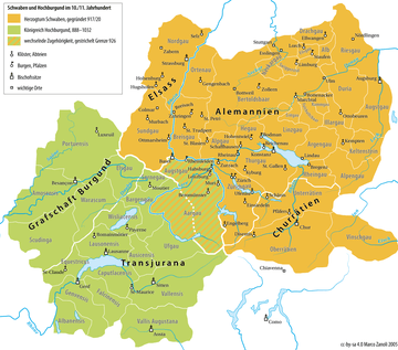
A map showing the Gaue/pagi of the Duchy of Swabia and Upper Burgundy around the beginning of the 11th century
It lists the names of the Frankish or German Gaue, many of which are still used today regionally, primarily in local traditions. Their locations are often no longer widely known, but are known from publications.
A
- Aachengau: around Aachen
- Aargau: predecessor of but not coextensive with the modern Swiss canton
- Ahrgau: on the Ahr river in the north of Rhineland-Palatinate
- Affagau or Apphagau: Swabian territory in modern Baden-Württemberg around Zwiefalten, Riedlingen and Hayingen
- Agradingau: covered territory in the north of the modern German Landkreis of Emsland and the Westerwolde in the Netherlands, between Aschendorf and Meppen.
- Alpgau or Albgau: in southern Baden between Wutach, Schwarzwald, the High Rhine and Baar; named after the Alb river
- Albuinsbar in southern Württemberg around Ehingen[1]
- Albegau[2] on the Meurthe (right tributary of the Mosel)
- Allgäu: southwestern Bavaria and southeastern Baden-Württemberg, today divided between:
- Oberallgäu: the Allgäu Alps and the surrounding area
- Unterallgäu: the northern foothills adjoining the Oberallgäu
- Ostallgäu on the Upper Bavarian border
- Westallgäu, including parts in the Landkreise of Lindau and Ravensburg
- Almango north of the Ittergau/Nithersi, east of Angeron, south of the Patherga
- Altkreis (Wangen)
- Altgau, around Bad Tennstedt and Großfurra
- Alzettegau[2] on the Alzette river in Luxembourg
- Ambergau: region northwest of the Harz in the catchment of the Nette around Bockenem, Lower Saxony
- Ammergau in Upper Bavaria
- Ammergau (Lower Saxony): modern Ammerland
- Angeron or Angerngau:[3] northwest of the Ittergau/Nithersi
- Anglachgau:[3] the right bank of the Rhine, probably between Rastatt and Mannheim
- Antisengau
- Apphagau: Swabian territory in modern Baden-Württemberg around Zwiefalten, Riedlingen and Hayingen
- Ardennengau: at the Tripoint of Germany, Belgium and Luxembourg (Vaalserberg)
- Arfeld[3]
- Argengau: the territory of the Argen on the northeastern shore of Lake Constance
- Aringo
- Aschfeld[3]
- Astfala (also Astfalia, Hastfala, Eastphaliagau): north of Hildesheim, west of Brunswick in Eastfalia in modern Lower Saxony
- Attergau: in Upper Austria
- Auelgau: south east of Bonn, Siebengebirge
- Augangau
- Augau: in Lower Saxony, on the Weser around Höxter, west of Nethegau
- Augstgau (Bavaria): around Augsburg on the Lech
- Augusta Raurica: the area south of the Rhine above Basel; named for the city of Augst (modern Kaiseraugst)
- Ausicensis (Pagus Ausicensis;[4] later the County of Gruyères; see Gruyères): in the upper Saane valley
- Gau Auricherland
- Avalgau
B
- Bachgau
- Badanachgau
- Balsamgau or Gau Balcsem, modern Saxony-Anhalt
- Baringau[3] between Tullifeld and Grabfeld in the central Rhöns, south-west Meiningen
- Balvengau: territory unidentified as it is not associated with a place name
- Betuwe in Gelderland, Netherlands
- Bardengau: the territory around Lüneburg
- Bargengau around Biel and Bern in Switzerland
- Berchtoldsbaar or Berchtoldsbaar (around 740): from Nagold to Schwenningen
- Bidgau or Bitgau:[2] South Eifel around Bitburg; named for the Vicus of Beda (modern Bitburg)
- Binagau or Bunnahagau: on the Vils and Isar
- Bliesgau[2] on the Blies (right tributary of the Saar)
- Bornegoa (Dutch: Bornego) in Friesland, Netherlands
- Bonngau (around Bonn)
- Borgelngau: territory unidentified as it is not associated with a place name
- Brabantgau (later the Duchy of Brabant)
- Gau Bracbanti[3] in Westphalia
- Breisgau, Southern Baden
- Brettachgau: the Landkreis of Heilbronn, Baden-Württemberg
- Gau Brokmerland
- Brukterergau[3]
- Buchonia[3] in the area of Rhön, Spessart and Vogelsberg
- Buchsgau: north-western Switzerland between the Juras and Aare
- Gau Budissin (Bautzen)
- Bukkigau: the Kreis of Schaumburg, Lower Saxony (Bukki being an old form of Buche)
- Bunnahagau: see Binagau
- Bulderngau: territory unidentified as it is not associated with a place name
- Burichingagau: in the Swabian Alps, southern part of Landkreis Reutlingen, northern part of Landkreis Sigmaringen
- Bursibant: around Rheine in the Münster region
C
- Chiemgau, Upper Bavaria
- Gau Chutizi: around Leipzig
- Gau Ciervisti: probably the same as Gau Zizizi, at the confluence of the Elbe and Saale around modern Zerbst
- Gau Circipani: around the Teterower See in Mecklenburg-West Pomerania
- Gau Coledizi: in Saxony-Anhalt, between Halle and Köthen
- Condroz
D
- Gau Daleminzi around Meissen
- Derlingau or Darlingau, east of Brunswick
- Dersagau or Dersigau, between Vechta and Damme
- Gau Desseri or Dasseri, on the Dosse
- Deutzgau: territory around Cologne (German: Köln) on the right bank of the Rhine; Kölngau (see below) lay on the opposite bank
- Dithmarschen (gau), Schleswig-Holstein
- Dobnagau in Vogtland
- Danubegau: the area around Straubing and Deggendorf in Bavaria
- Drachgau around Schwäbisch Gmünd
- Dreingau in the Münster region, between Greven, Lippstadt and Lünen
- Dreinigau[3] in Saxony
- Drentgau in Westphalia
- Gau Ducharin (also Thucharin or Tucherini), around Teuchern in Saxony-Anhalt
- Düffelgau: in the area around Cleves; attested in the donation of Willibrord, stretching up to Betuwe or Hattuariergau
- Duisburggau or Diuspurggau: see: Ruhrgau
- Durgouwes - see: Mürztalgau
- Duriagau in Swabia
E
- Eastergoa or Ostergau in Friesland, Netherlands
- Eichelgau[2] on the Eichel (right tributary of the Saar)
- Eichsfeld with the sub-Gau Onsfelt
- Eifelgau in north-west Eifel
- Einrich[3] or Einrichgau, around Katzenelnbogen
- Elsenzgau:[3] the territory of Elsenz in North Baden
- Elsgau: Ajoie, in the north of the Canton of Jura, Switzerland
- Emsgau or Gau Emsigerland: situated at the mouth of the Ems
- Engersgau[3] on the right bank of the Middle Rhine and Westerwald
- Enggau
- Gau Engilin in Central Thuringia west of the Unstrut
- Ennstalgau: the Styrian Enns valley (including side-valleys) plus Ausseerland
- Enzgau in Northern Württemberg on the Enz
- Erchgau in Southern Württemberg, on the Danube around Munderkingen
- Erdagau[3] in modern Lahn-Dill-Kreis, Hesse
- Erdinggau or Hertinggau, around modern Erding
- Eriggau
- Ertgau or Eritgau
F
- Federgo
- Flachgau (part of the Salzburg lands): arose in the 19th century as a result of the division of the Salzburggau (the other part becoming Tennengau); not a medieval Gau.
- Gau Flenithi (also Flenithigo or Flenthigau): in Gandersheim/Winzenburg region
- Filsgau in Swabia on the Fils
- Flutwidde (also Flutwide, Flotwito or Flotwede) in the Celle–Burgdorf–Peine city triangle in modern Lower Saxony.
- Folkfeld[3] or Volkfeld, situated on the Main (in Lower Franconia) around Bamberg
- Folkoltsbar[1] in Southern Württemberg, on the Danube around Obermarchtal
- Frickgau between the Rhine and Aare around Frick (Fricktal)
- Friesach in Northern Carinthia; included the territory around Murau, St. Lambrecht and Neumarkt/Graslupp/Graslab in modern Styria
- Friesenfeld
- Frithenigau
G
- Gandesemigau
- Gartachgau in Northern Württemberg on the Gartach/Leinbach
- Gau Jom: controversial historical territory settled by and subject to the Jomsvikings as well as a Danish exclave on the Pomeranian coast
- Gäu, Baden-Württemberg
- Gäu in the Canton of Solothurn, Switzerland
- Genfer Gau, Switzerland
- Gerbercensis:[2] name only preserved in its Latin form; northwest of Metz on the Orne
- Germar-Mark or Germara-Mark in East Hesse and Thuringia
- Gau Geraha in East Thuringia
- Gillgau: on the Lower Rhine region north-west of Cologne; known at the time as Kölngau ('Cologne Gau')
- Glehuntare in Swabia
- Glemsgau in Northern Württemberg on the Glems
- Godobi in Upper Lusatia: Early Medieval castle or Gau, first documented in 1007; probably the same as Göda
- Goe auf der Hamel, north of Hamelin
- Gollachgau
- Goßfeld[3] in Franconia
- Gotzfeldgau, probably in Southern Hesse
- Grabfeld[3] or Grabfeldgau: situated on the border between Bavaria and Thuringia; Schweinfurt lies just within the southern part of this Gau.
- Grönegau around Osnabrück
- Gudingau or Gud(d)ingo, around Elze in the Saale valley up to the Leine
- Gau Gunzwiti, west of the Traisen in Lower Austria
H
- Haduloha, around Land Hadeln and Wursten (see History of Hadeln and Wursten)
- Haigergau: around Haiger, a sub-Gau of Oberlahngau
- Haistergau in Upper Swabia
- Hamaland
- Hardagau
- Gau Harlingerland
- Harzgau: Harz
- Hasegau: around Löningen in the west of Oldenburger Münsterland
- Haspengau in Belgium between Liège and Hasselt on the left bank of the Meuse
- Hassegau: between Mansfeld, Naumburg, Halle and Wettin
- Hassgau: the Haßberge Hills in Lower Franconia
- Hastfalagau (also Astfalia, Hastfala, Eastphaliagau): in Eastphalia (modern Lower Saxony) north of Hildesheim and west of Brunswick
- Hattenhuntare (789): Hechingen excluding the Killertal and Alborte, and including the municipality of Steinlach up to Dußlingen
- Hatterungau, Lower Rhine
- Hattuariergau along the Niers, including Gennep and Geldern
- Hegau, southern Württemberg
- Heilangau: Bremervörde, Buxtehude, Harburg, Stade etc.
- Helmegau: around Wallhausen and Kelbra, and from Kleinwangen to the Saale
- Hengistgau: West Styria, centred on Hengistburg/Hengsberg
- Hennegau (also Hainaut, Hennegouw(en), in Belgium)
- Hessengau[3] or Hessigau
- Hettergau, Hattuariergau or pagus Attoarii
- Hlidbeki-Gau: from Lübbecke in Westphalia to the Dümmer See
- Holstengau in Schleswig-Holstein
- Gau Hrecwiti in Westphalia
- Hunsrückgau
- Huosigau in Bavaria
- Husitingau or Usitigau, around Weimar
- Huygau in the former Kingdom of Lotharingia
I
- Iffgau: territory south of the Steigerwald, Franconia
- Undrimagau or Ingeringgau: territory around Knittelfeld and Judenburg, Upper Mur Valley (Murtal)
- Illergau in south-eastern of Baden-Württemberg and south-western Bavaria
- Isengau on the Isen in south-eastern Upper Bavaria
- Itongau[2] on the upper Nied (left tributary of the Saar)
- Ittergau[3] (Nithersi) on the middle Eder
J
- Jagstgau on the lower Jagst
- Jaun: Jauntal, Carinthia, in the south-east up to Windischgraz/Slovenj Gradec and down the Drava (German: Drau) until it reaches the Wölka/Velka- and Tschermenitzen/Crmenica-Graben. Note that while Jauntal translates as 'Jaun valley', its name is derived from the Roman settlement of Juenna near modern Globasnitz rather than a river named Jaun.
- Jülichgau around Jülich, southwestern North Rhine-Westphalia
K
- Karosgau:[2] Eifel around Prüm
- Keldachgau: Düsseldorf, Mettmann and part of Solingen; later the County of Berg
- Kelsgau: territory in the area of the district of Kelheim
- Kennemerland (a.k.a. Kinhem, Kinnin, Kemmenerland, Kimmen), in Frisia; part of modern North Holland, Netherlands
- Kinziggau: the territory of Kinzig in Hesse
- Klettgau: southern Baden and Northern Switzerland
- Knetzgau
- Kochergau or Cochengowe: the territory of the Kocher valley in the north of modern Baden-Württemberg
- Kölngau: territory around Cologne on the left bank of the Rhine; the territory on the right bank was Deutzgau
- Königssondergau, Königssandragau or Königssandern,[3] i.e. the Königs besonderer Gau ('King's special Gau'), around Wiesbaden
- Kraichgau, northern Baden
- Kroatengau or Gau Chrowati (literally 'Gau of the Croats'): the Glan/Glina valley around Sankt Veit an der Glan and the Krappfeld north-east of Sankt Veit (Carinthia)
- Künziggau (a.k.a. Künzinggau, Quinzinggau, Chunzengau): territory on the Vils and Rott, south-west of Passau (Landgericht Landau-Osterhofen)
- Kützgau: partitioned from the Zülpichgau; only one documented mention in the year 898
L
- Largau
- Lahngau:[3] the territory of Lahn in Hesse including Gießen, Marburg and Wetzlar; the original territory of the Conradines
- Niederlahngau or Unterlahngau around Limburg
- Oberlahngau around Marburg
- Längwitzgau in Thuringia
- Leinegau or Loingau:[3] territory around the lower Leine between the lower Leine valley and the High Heath in Lower Saxony
- Gau Lengenerland in East Frisia
- Leobengau: territory around Leoben, Styria
- Lerigau in Lower Saxony, west of the middle Hunte up to the upper Soeste
- Liergau (a.k.a. Liergewe, Leraga, Gau Lera or Leragau): between Fuhse and Oker
- Liesgau[3] in southern Lower Saxony; western Harzvorland
- Gau Liezizi
- Linzgau, southern Baden-Württemberg
- Lobdengau[3] east of Mannheim, north of Heidelberg around Ladenburg
- Lochtropgau in the Sauerland, in the former Amt of Fredeburg, North Rhine-Westphalia)
- Lohra[3]
- Loingau: see Leinegau
- Lommegau: the territory around Namur
- Lommatschgau possibly in Belgium
- Lungau, part of the Salzburg lands
- Lurngau: the area around Spittal an der Drau, Carinthia. (See also: Matrei im Hochmittelalter on the German Wikipedia)
- Lusiza: stem territory of the Slavic Lusitzi in modern Lower Lusatia
- Lüttichgau: the territory around Liège (German: Lüttich)
M
- Maasgau, west of the Maas around Maastricht
- Maifeld
- Maingau:[3] earlier Monichgowe around Aschaffenburg, Dieburg and Frankfurt am Main; later known as:
- Bachgau
- Rodgau
- Marstemgau around Hanover
- Mattiggau in the Innviertel, Upper Austria around Mattighofen
- Maulachgau or Mulachgau
- Mayenfeldgau (East Eifel); see Maifeld
- Methingau,[2] French: Matois: the Pays haut between Longwy and Briey
- Metzgau,[2] the area immediately surrounding Metz
- Gau Milsca, in Upper Lusatia. Territory settled by the Slavic Milceni around Bautzen
- Gau Moormerland
- Moraciani on the eastern shore of the Elbe from Magdeburg-Pechau up to Schartau
- Moringen
- Moselgau[2] on the Mosel around Thionville
- Mühlgau: between Maas and Niers
- Munachgau
- Munderkinger Gau/Muntariche Huntare in Southern Württemberg around Munderkingen[1]
- Munigiseshuntare around Münsingen
- Gau Murizzi, on the Müritz
- Murrgau in Northern Württemberg on the Murr
- Mürztalgau or Durgouwes: Styrian Mürz valley including side valleys and the land around Mariazell
N
- Nabelgau in Thuringia
- Nagoldgau
- Nahegau[3][2] on the Nahe
- Neckargau[3]
- Gau Neletizi east of the Saale around Nehlitz including the castle Giebichenstein (Halle)
- Gau Neletici on the Mulde around Wurzen
- Nethegau or Netgau around Brakel and Bad Driburg in Westphalia
- Netragau
- Nibelgau: southeastern Baden-Württemberg
- Niddagau:[3] territory on the Nidda in central Hesse around Friedberg and Bad Homburg vor der Höhe)
- Niebelgau in southeastern Baden-Württemberg (or possibly Rhineland-Palatinate)
- Niederlahngau – see: Lahngau
- Niedgau[2] on the Nied (left tributary of the Saar)
- Nielitizi
- Nisangau or Gau Nisane: south-east of Dresden
- Gau Nizizi: territory between the Elbe, Mulde and Black Elster
- Nithersi: see Ittergau
- Gau Norderland in East Frisia
- The Bavarian Nordgau: Bavaria north of the Danube
- The Alsatian Nordgau; approximately modern Bas-Rhin, France
- Nordthüringgau or Nordthüringengau in modern Saxony-Anhalt. Formed from the territory of the Thuringii which had become part of the Stem Duchy of Saxony
- Norital (Inntal, Wipptal and Eisacktal)
- Gau Nudzici: east of the Saale between Halle and Bernburg
O
- Oberaargau (Latin: superior pagus Aragauginsis), the western part of the Aargau
- Oberlahngau: see Lahngau
- Oberrheingau ('Upper Rhine Gau'), southern Hesse; not to be confused with the upper Rheingau around Eltville
- Ochsenfurter Gau around Ochsenfurt in Lower Franconia
- Odangau around Villip, Werthhoven, Oedingen and Unkel. It was situated on both sides of the Rhine in the 9th century; after that it was divided into the Bonngau, Ahrgau and Auelgau
- Östringen around Jever in eastern Frisia
- Orlagau around Saalfeld in Thuringia
- Ortenau or Mortenau, central Baden
- Gau Osterwalde (Altmark)
- Osterburg-Gau in the Weserbergland
- Ostergau or Eastergoa in Friesland
- Ostergau in Thuringia
- Ostrusna in Upper Lusatia: early medieval castle or Gau documented from 1007; probably the same as Ostritz
- Gau Overledingerland in East Frisia
P
- Padergau[3] around Paderborn
- Perfgau on the Hessian-North Rhine-Westphalian border, in the Landkreis of Marburg-Biedenkopf
- Pfinzgau on the Pfinz east of Karlsruhe
- Pfullichgau (after 937) in Baden-Württemberg: Pfullingen, Lichtenstein and Engstingen
- Phirnigau
- Pinzgau, part of the Salzburg lands
- Gau Plisni (Pleißenland)
- Plumgau,[3] modern Spessart
- Gau Polabi, around Ratzeburg
- Pongau, part of the Salzburg lands
- Prättigau, a valley in the Swiss Canton of Graubünden
- Gau Puonzowa around Zeitz
- Gau Pustertal, Pustertal
Q
- Gau Quesizi around Burg Eilenburg in the Landkreis of Delitzsch, Saxony)
- Quinzinggau, see Künzinggau
R
- Radenzgau, Upper Franconia
- Rammachgau, northern Upper Swabia
- Rangau around Nürnberg
- Rebgau, Upper Austria
- Gau Rheiderland
- Rheingau[3] around Wiesbaden and Darmstadt
- Riesgau around Nördlingen
- Ringgau
- Ripuariergau southwestern Bonn, Rhinebach and Münstereifel)
- Rittigau around Northeim, southern Lower Saxony
- Gau Rizani
- Rizzigau[2] (Latin: Pagus Reciensis after the Vicus of Ricciacum) around Dalheim, 10 km west of Remich in Luxembourg
- Rosselgau[2] on the Rossel (left tributary of the Saar)
- Rotagau (or Rottgau, Rottachgau) around Passau
- Gau Rüstringen immediately west and east of modern Jadebusen
- Gau Ruppmannsburg (or Rodmaresperch)[5]
- Ruhrgau or Duisburggau: modern western Ruhrgebiet including Duisburg and Essen
- Rurgau: the territory of Rur in North Rhine-Westphalia in the Aachen district). Note: Rurgau and Ruhrgau were frequently confused/transposed in older literature.
S
- Saalgau around Hammelburg
- Saalegau[3] in Thuringia
- Saargau[2] on the Saar
- Upper Saargau (Latin: Sarachuua subterior) around Sarrebourg
- Lower Saargau (Latin: Sarachuua inferior) around Wallerfangen
- Salingau (Saulnois; roughly corresponds to the modern French arrondissement of Château-Salins
- Salzgau was the name of several separate Gaue:
- Easphalian Salzgau or Saltgau (comecia Saltga, pagus Saltgo), around Salzgitter in Lower Saxony
- Lower Franconian Salzgau on the Saale around Bad Neustadt
- Lorrainer Salzgau (Latin: Salinensis Paganus, French: Saulnois) in the south of the modern French Département of Moselle
- Salzburggau: Flachgau and Tennengau in Austria, Rupertiwinkel and the Reichenhall valley in Bavaria
- Sanntalgau, in Lower Styria (modern Slovenia). Formed the basis of the Mark an der Sann, which later became the County of Cilli
- Sauergau[2] on the Sauer in Luxembourg
- Gau Saterland
- Scarponagau[2] (French: Scarponois), named for the Vicus of Scarpona: around Dieulouard on the Mosel between Toul and Metz
- Schefflenzgau[3] in Württemberg. Odenwald
- Scherragau around Ebingen, Spaichingen, Tuttlingen
- Schozachgau in Northern Württemberg on the Schozach
- Schussengau in Upper Swabia
- Schwabengau western Saxony-Anhalt
- Schweinachgau territory on both sides of the Danube west of Passau (Bavaria) (Landgericht Vilshofen)
- Schwerzgau in southern Württemberg, around Allmendingen
- Gau Scotelingo or Scotelingen, west and northwest of Hildesheim
- Seillegau[2] (French: Saulnois), on the Seille (right tributary of the Mosel) around Salzburgen
- Senonagischer Gau: territory in modern France; area of origin of Samo
- Gau Serimunt: territory between the Saale, Mulde, Elbe and Fuhne
- Sisgau north-west Switzerland
- Gau Siusili (or Susali) in the Leipzig Basin on the Mulde in Saxony
- Skopingau around Schöppingen, Münster, North Rhine-Westphalia
- Sornegau on the left bank of the Rhine south of Basel, Switzerland
- Speyergau[3] around Speyer
- Stevergau around Coesfeld, Münster, North Rhine-Westphalia
- Stormarn (Gau), Schleswig-Holstein
- Strudengau, Lower Austria
- Sturmigau: modern Verden district; from Hoya on the right of the Weser over the Allermündung in the east of the Landkreis of Verden[6]
- Sualafeldgau, Bavaria
- Südthüringengau (or Südthüringgau)
- Suilbergau; also "Suilberigavvi" or Sülberggau: west of the Leine around Einbeck in Lower Saxony with central court (Gerichtsstätte) at the Sülberg around Strodthagen
- Sülchgau or Sülichgau in Swabia: around Rottenburg am Neckar; approximately the modern Landkreis of Tübingen
- Sulmgau around Neckarsulm
- Sulzgau or Solzgowe
- Sundergau, Bavaria
- Sundgau, Upper Alsace
- Swistgau on the upper Swist on the north-eastern edge of Eifel
T
- Taubergau approximately the Main-Tauber-Kreis, excluding Wertheim
- Tennengau, part of the Salzburg lands: arose in the 19th century as a result of the division of the Salzburggau (the other part becoming Flachgau); not a medieval Gau.
- Gau Threcwiti, east of the Großes Heiliges Meer in North Rhine-Westphalia
- Thurgau; not coextensive with the modern Swiss Canton of Thurgau
- Tilithigau around Bad Pyrmont, southern Lower Saxony
- Traungau: territory between Hausruck and Enns, Upper Austria
- Trebista in Upper Lusatia; early medieval castle or Gau first attested from 1007
- Trechirgau, situated south of the Lower Mosel and west of the Rhine from the beginning of the 10th century. Lay between the Mayenfeldgau and the northern foothills of the Nahegau
- Triergau[2] on the right banks of the Saar and Mosel, from Merzig to Wintrich and from there to the Schwarzwalder Hochwald)
- Tullifeld[3] in western Thuringia north-east of the Wasserkuppe
U
- Ufgau, Central Baden
- Undrimagau or Ingeringgau: territory around Knittelfeld and Judenburg, Upper Mur Valley
- Utisigau: see Husitingau
V
- Valingau with Gut Kemme in Schellerten, Burg Poppenburg in Burgstemmen; from 1049 part of the County of Bruno II of Brunswick
- Valothungo
- Varngau
- Gau Veluwe in the Netherlands
- Venkigau or Fenkiongau: lay to the east of Gau Bursibant
- Venzigau
- Verdungau[2] around Verdun on the Maas
- Viehbachgau on the Lower Isar, in the Landshut area
- Vinschgau or Vintschgau; known in the Middle Ageas as Finsgowe; located in South Tirol
- Volkfeld: see Folkfeld
W
- Wachau, Lower Austria
- Walchgau
- Waldgau or the Waldenser Gau: comprised the modern Canton of Waadt and other territories in Switzerland
- Waldsassengau[3] in Lower Franconia: the eastern part of Spessart and the territory between Mainviereck and Maindreieck
- Waldsati between Bremen and Zeven
- Walgau, Vorarlberg
- Wallis, Switzerland
- Walderfinga[2] on the Middle Saar
- Gau Wangerland
- Gau Warnabi
- Wasgau in the Palatinate Forest: northern part of the Voges region
- Watergau in Thuringia
- Wavergau (a.k.a. Wabergau, Woëvregau):[2] part of the Wabr(i)a (Woëvre) region between the Maas and the Mosel
- Wehsigau
- Weitagau in Westphalia
- Werinofeld in Thuringia
- Werngau[3] in Hesse
- Westergau, meaning Western Gau was the name of several separate Gaue:
- Westphaliagau in the Ruhr and Lippe area, roughly corresponding with the eastern (Westphalian) part of the modern Ruhrgebiet
- Wetagau in Thuringia
- Wetigau the Schwalenberg area in the district of Lippe
- Wetterau (earlier Wettergau or Wettereiba)[3]
- Gau Wigmodi (Wigmodia, Wigmodien) north of Bremen
- Wingarteiba[3] in the Neckar-Odenwald-Kreis
- Wiehegau: a sub-Gau of Gau Englin around Wiehe in Thuringia
- Wippergau in Thuringia
- Wittingau
- Wonnegau around Worms
- Wormsgau[3] (also Wormsfeld, Wormsfeldgau):[2] west of Worms
- Würmgau in Württemberg on the Würm river
Z
- Zabergäu in northern Württemberg on the Zaber
- Gau Zemzizi
- Zirzipanien, around the Teterower See in Mecklenburg-Vorpommern
- Gau Zistanesfeld (or Zitilinesfeld) in Lower Styria (modern Slovenia): the territory of Maribor (German: Marburg an der Drau) on the Drava (German: Drau) up to Pettau. Formed the basis of the Mark an der Drau.
- Gau Zitizi (Zizizi): probably the same as Gau Ciervisti around what is now Zerbst in Saxony-Anhalt
- Gau Zwikowe in western Saxony
- Zülpichgau around Zülpich, southwestern North Rhine-Westphalia
- Zürichgau around Zürich
See also
- List of Alamannic pagi, a list of Gaue/pagi in the Stem Duchy of Swabia
Sources
- August von Wersebe: Beschreibung der Gaue between Elbe, Saale und Unstrut, Weser und Werra, insofern solche zu Eastphalia mit Nord-Thuringia und zu Ost-Engern gehört haben, und wie sie im 10ten und 11ten Jahrhundert befunden sind. Hahn, Hannover 1829, Digitalisat.
- Wachter, Ferdinand (1852). "1: A – G. Theil 54: Gargano – Gauhe.". In Ersch, Johann S.; Gruber, Johann G. (eds.). Allgemeine Encyclopädie der Wissenschaften und Künste [General Encyclopedia of the Sciences and Arts] (in German). Leipzig: Brockhaus. pp. 405–449.
- Boettger, Heinrich. Diöcesan- and Gau-Grenzen Norddeutschlands zwischen Oder, Main, jenseits des Rheins, der Nord- und Ostsee. Von Ort zu Ort schreitend festgestellt [Diocese and Gau borders of northern Germany between the Oder, Main, beyond the Rhine, the North Sea and the Baltic Sea] (in German). Buchhandlung des Waisenhauses u. a., Halle u. a. 1875–1876:
- Volume 1: Von Ort zu Ort schreitende Begrenzung von 31 Gauen und 10 Untergauen in 7 Bisthümern und 108 geistlichen Bezirken in Franken, nebst einer Gau- und einer dieselbe begründenden Diöcesankarte [From place to place progressing boundaries of 31 Gaue and 10 sub-Gaue in 7 bishoprics and 108 ecclesiastical districts in Franconia, in addition to a Gau map and a corresponding diocese map], 1875
- Volume 2: Von Ort zu Ort schreitende Begrenzung von 40 Gauen und 39 Untergauen in 6 Bisthümern und 130 geistlichen Bezirken im Umfange der Provinz Hannover, nebst einer Gau- und einer dieselbe begründenden Diöcesankarte. [From place to place progressing boundaries of 40 Gaue and 39 sub-Gaue in 6 bishoprics and 130 ecclesiastical districts in the province of Hanover, in addition to a Gau map and a corresponding diocese map], 1874
- Volume 3: Von Ort zu Ort schreitende Begrenzung von 43 Gauen und 24 Untergauen in 6 Bisthümern und 110 geistlichen Bezirken in Altsachsen und Friesland, nebst einer Gau- und einer dieselbe begründenden Diöcesankarte. [From place to place progressing boundaries of 43 Gaue and 24 sub-Gaue in 6 bishoprics and 110 ecclesiastical districts in Old Saxony and Frisia, in addition to a Gau map and a corresponding diocese map], 1875
- Volume 4: Von Ort zu Ort schreitende Begrenzung von 60 Gauen and 11 Untergauen in 7 Bisthümern und 148 geistlichen Bezirken im Umfange des Slavenlandes, nebst einer Gau- und einer dieselbe begründenden Diöcesankarte. [From place to place progressing boundaries of 60 Gaue and 11 sub-Gaue in 7 bishoprics and 148 ecclesiastical districts in the lands of the Slavs, in addition to a Gau map and a corresponding diocese map], 1876
- Gaukarte und eine dieselbe begründende Diöcesankarte zu den Diöcesan- und Gaugrenzen Norddeutschlands. [Gau map and a corresponding diocese map of the diocese and Gau borders of northern Germany], 1876
- Schultze, Walther (1896). Die fränkischen Gaue Badens [The Frankish Gaue of Baden] (in German). Stuttgart: Strecker & Moser.
References
- Beschreibung des Oberamts Ehingen § Geschichtliche Denkwürdigkeiten (on Wikisource in German: 'Description of the Oberamt of Ehingen § Historically Notabilities')
- Puhl, Roland W. L. Die Gaue and Grafschaften des frühen Mittelalters im Saar-Mosel-Raum: Philologisch-onomastische Studien zur frühmittelalterlichen Raumorganisation anhand der Raumnamen and der mit ihnen spezifizierten Ortsnamen [The Gaue and Counties of the early middle ages in the Saar-Mosel area: Philological-onomastic studies of early medieval territorial organisation based on the territory names and their broken-down place names] (in German). 13. Beiträge zur Sprache im Saar-Mosel-Raum. Saarbrücker Druck und Verlag, Saarbrücken, 1999 -and- Saarbrücken Universität, Dissertation, 1996. ISBN 3-930843-48-X.
- "Geschichtlicher Atlas von Hessen: Die Gaue vor 900" [Historical Atlas of Hesse: The Gaue before 900]. Landesgeschichtliches Informationssystem Hessen (in German). 2006.
- Marie-Claire Gérard-Zai / GL: Ogoz in German, French and Italian in the online Historical Dictionary of Switzerland.
- Norbert Herler (Red.): Laibstadt – Ein Dorf verändert sich. Zum 25-jährigen Bestehen des Heimat- and Verschönerungsvereins Laibstadt 1976–2001. Heimat- and Verschönerungsverein Laibstadt, Laibstadt 2001, S. 19.
- Heimatkalender für den Landkreis Verden. Bd. 31, 1988, ISSN 0948-9584, S. 158.
This article is issued from Wikipedia. The text is licensed under Creative Commons - Attribution - Sharealike. Additional terms may apply for the media files.