Lindau (district)
Lindau is a Landkreis (district) in Swabia, Bavaria, Germany; its capital is the city of Lindau. It is bounded by (from the east and clockwise) the district of Oberallgäu, Austria (federal state of Vorarlberg), Lake Constance and the state of Baden-Württemberg (districts of Bodensee and Ravensburg).
Lindau | |
|---|---|
%26groups%3D_388cf57085259290cafa5674af59362f43776e2d.svg)
| |
| Country | Germany |
| State | Bavaria |
| Adm. region | Swabia |
| Capital | Lindau |
| Area | |
| • Total | 323 km2 (125 sq mi) |
| Population (31 December 2018)[1] | |
| • Total | 81,669 |
| • Density | 250/km2 (650/sq mi) |
| Time zone | UTC+01:00 (CET) |
| • Summer (DST) | UTC+02:00 (CEST) |
| Vehicle registration | LI |
| Website | landkreis-lindau.de |
History
The city of Lindau became a Free Imperial City in the 13th century; it was directly subordinate to the emperor. The rural areas around Lindau were the property of monasteries or tiny counties, that rose and fell in the region. When Napoleon gained influence in the area, all these entities were dissolved in the German Mediatisation. Lindau fell to Bavaria.
The district of Lindau was established in 1938. After the Second World War it became part of the French zone of occupation, while the rest of Bavaria was under American occupation. In 1955 the district was reincorporated into Bavaria. The city of Lindau, which had been an urban district, became a part of the rural district in 1972.
Geography
In the southwest the district borders Lake Constance, more precisely its eastern part known as Obersee. To the north the countryside rises to the hills of the western Allgäu mountains.
Coat of arms
 Coat of arms |
The coat of arms displays:
|
Towns and municipalities
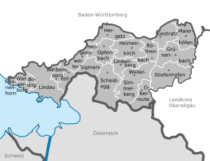
| Towns | Municipalities | |
|---|---|---|
References
- "Fortschreibung des Bevölkerungsstandes". Bayerisches Landesamt für Statistik und Datenverarbeitung (in German). July 2019.
External links
| Wikimedia Commons has media related to Landkreis Lindau (Bodensee). |
- Landkreis Lindau (German)
Towns and municipalities in Lindau (district) | ||
|---|---|---|
Coat of Arms of Lindau district | ||
| Authority control |
|
|---|