Traisen (river)
The Traisen (German pronunciation: [ˈtʀaɪ̯zn̩] (![]()
![]()
| Traisen River | |
|---|---|
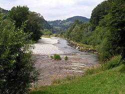 The Traisen between Traisen and Wilhelmsburg | |
| Location | |
| Country | Austria |
| Physical characteristics | |
| Source | |
| ⁃ location | near St. Aegyd am Neuwalde and Türnitz |
| Mouth | |
⁃ location | Danube |
⁃ coordinates | 48°22′20″N 15°51′51″E |
| Length | 82.6 km (51.3 mi) [1] |
| Basin features | |
| Progression | Danube→ Black Sea |
The Traisen is formed from the rivers Türnitzer Traisen and Unrechttraisen. Its total length, including the Türnitzer Traisen, is 82.6 km (51.3 mi).[1] It is a tributary of the Danube in the Lower Austrian region of Mostviertel. Its two sources begin near St. Aegyd am Neuwalde and Türnitz respectively. After meeting, they flow through the municipalities of Türnitz, Lilienfeld, Traisen, Wilhelmsburg, and St. Pölten, before meeting the Danube at Traismauer. In the course of building the Danube power station Altenwörth, the mouth of the Traisen was relocated to Altenwörth in the municipality of Kirchberg am Wagram.
During a period of extremely high water in July 1997, parts of numerous municipalities along the Traisen, as well as the government quarter of the state capital St. Pölten, were greatly flooded.
References
- Niederösterreich Atlas (Lower Austria)
External links

| Authority control |
|
|---|