Vaalserberg
The Vaalserberg is a hill with a height of 322.4 metres[1] (1,058 ft) above NAP and is the highest point in mainland Netherlands. The Vaalserberg is located in the province of Limburg, at the south-easternmost edge of the country, near the town of Vaals (after which it is named).
| Vaalserberg | |
|---|---|
 The Vaalserberg seen from Aachen | |
| Highest point | |
| Elevation | 322.4 m (1,058 ft) NAP |
| Coordinates | 50°45′17″N 6°01′15″E |
| Naming | |
| English translation | Vaals Mountain |
| Language of name | English |
| Geography | |
 Vaalserberg Netherlands | |
| Location | Limburg, Netherlands |
After the dissolution of the Netherlands Antilles and incorporation of Saba into the Netherlands in 2010, the Vaalserberg was replaced by Mount Scenery as the highest point in the Netherlands.
Three-country point

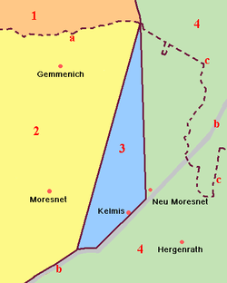
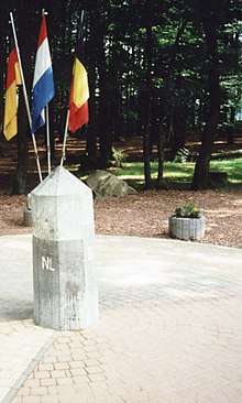
The Vaalserberg is also the location of the tripoint between Germany, Belgium and the Netherlands and so its summit is called the Drielandenpunt ("three country point") in Dutch, Dreiländereck ("three country corner") in German and Trois Frontières ("three borders") in French.
On the Belgian side, the tripoint borders the region of Wallonia, including both the regular French-speaking area and the smaller German-speaking area. Between 1830 and 1919, the summit was a quadripoint, also bordering Neutral Moresnet, which is now part of Belgium's German-speaking area.
Legend:
The current Belgian-German-border is not the same as the former eastern border of Moresnet with Prussia but is a little more to the east. Therefore, five different borders came together at this point but never more than four at one time, except possibly between 1917 and 1920, when the border situation was unclear and disputed.
The border intersection has made the Vaalserberg a well-known tourist attraction in the Netherlands, with a 50 m tower on the Belgian side (Dutch: Boudewijntoren; French: Tour Baudouin; German: Balduin-Turm), opened in 1994 to replace the previous 33 m tower, built in 1970. It offers a grand panorama of the surrounding landscape.
Four-borders road
The road leading up to this point on the Dutch side is called the Viergrenzenweg ("four borders way"), probably because of the territory of Moresnet. The names of the roads in Belgium (Route des Trois Bornes) and Germany (Dreiländerweg) refer to only three.[2] Along the road on the Dutch side is the 35 m Wilhelminatoren observation tower, with a restaurant and forest trails. The present tower officially opened on 7 October 2011 and features a lift and a glass floor. The first tower at the site was built in 1905 during the reign of its namesake, Queen Wilhelmina of the Netherlands, and was demolished in 1945. The second 20 m tower opened on 11 August 1951 and was demolished over the winter of 2010-2011 because of its poor condition and high maintenance requirements.
Road cycling
The Vaalserberg is often used in the Amstel Gold Race and is climbed halfway through the race. The climb is named in the roadbook of the Gold Race as Drielandenpunt and is followed by the Gemmenich climb.
Gallery
 The Three-Country Point c.2000
 Three-Country Point viewed from the Boudewijntoren, April 2018
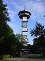 The Boudewijntoren observation tower
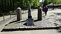 Monument, officially opened in 1928, up the Vaalserberg marking the highest point in mainland Netherlands by the Three-Country Point
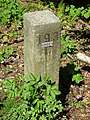 One of several concrete posts marking the border between Germany and the Netherlands in the forest
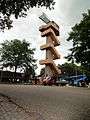 The present Wilhelminatoren observation tower
.JPG) The previous Wilhelminatoren (1951–2010)
The previous Wilhelminatoren (1951–2010)
See also
- List of mountains and hills in North Rhine-Westphalia
References
- (in Dutch) J.A. te Pas, Nederland van laag tot hoog, NGT Geodesia 1987 nr. 7/8 pp. 273-275
- See Google Maps showing streetnames
| Wikimedia Commons has media related to Border triangle Vaalserberg. |