Kraichgau

The Kraichgau  is a hilly region in Baden-Württemberg, southwestern Germany. It is bordered by the Odenwald and the Neckar to the North, the Black Forest to the South, and the Upper Rhine Plain to the West. To the east, its boundary is considered to be the Stromberg and the Heuchelberg.

Physical map of the Kraichgau (within brown line)
View from the Ravensburg near Sulzfeld over the Kraichgau hills to their highest point, Burg Steinsberg (centre, on the horizon)
Steinsberg Castle on the eponymous hill, the highest point of the Kraichgau
The prominent Catholic parish church of Waibstadt
Ruins of the water castle in Kraichtal-Menzingen

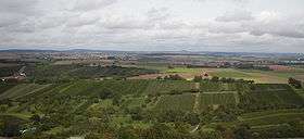
The largest towns of the Kraichgau are Sinsheim, Eppingen, and Bretten. On the western end of the Kraichgau is the town of Bruchsal, the gateway to the Rhineland plains.

Origins of the name

The word "Kraich" apparently arose from the Celtic word "Creuch," meaning "mud" or "loam." The territory of a Gau (country subdivision) signifies an open area, free from woods, such as farmland or meadows.

The area of Kraichgau was first mentioned in the Early Middle Ages, in the Lorsch codex, as "Creichgowe" in the year 769. In 773, it was called "Chrehgauui," in 778 "Craichgoia." By 1594, the name was closer to its modern form, being referred to as "Kreuchgau."

See also


This article is issued from Wikipedia. The text is licensed under Creative Commons - Attribution - Sharealike. Additional terms may apply for the media files.