List of listed buildings in Perth, Perth and Kinross
List
| Name | Location | Date Listed | Grid Ref. [note 1] | Geo-coordinates | Notes | LB Number [note 2] | Image |
|---|---|---|---|---|---|---|---|
| 10 St Leonard's Bank, Including Boundary Walls | 56°23′24″N 3°26′14″W | Category B | 39631 |  | |||
| South Street 43-53 (N. Side). (Odd Numbers) | 56°23′43″N 3°25′43″W | Category B | 39638 | | |||
| South Street 75-81 (Odd Numbers) Salvation Army Hall And 30-36 King Edward Street (Even Numbers) | 56°23′43″N 3°25′47″W | Category C(S) | 39640 | | |||
| Stormont Street, 6 | 56°24′00″N 3°26′01″W | Category C(S) | 39652 | | |||
| Tay Street, 26, Savings Bank | 56°23′47″N 3°25′34″W | Category B | 39655 | | |||
| 39-45 (Odd Nos) Victoria Street, Including Boundary Wall | 56°23′37″N 3°26′01″W | Category C(S) | 39659 | | |||
| Watergate, 81 | 56°23′43″N 3°25′37″W | Category C(S) | 39662 | | |||
| 1-9 (Odd Nos) York Place And 41-45 (Odd Nos) New Row | 56°23′44″N 3°26′11″W | Category B | 39665 | | |||
| 27 (Inglelowe) And 29 (Hollybrook) Wilson Street, Including Boundary Walls, Gates And Railings | 56°23′19″N 3°26′37″W | Category B | 39666 | | |||
| 1-14 (Inclusive Nos) Marshall Place And 2 And 4 Nelson Street Including Boundary Walls And Railings | 56°23′32″N 3°25′45″W | Category B | 39552 | | |||
| 15-28 (Inclusive Nos) Marshall Place, 1 And 3 Nelson Street And 110 Scott Street Including Boundary Walls And Railings | 56°23′32″N 3°25′53″W | Category B | 39553 | | |||
| 46-50 (Even Nos) South Methven Street | 56°23′45″N 3°26′03″W | Category C(S) | 39576 | | |||
| Rose Terrace, 8-12 (All Numbers) | 56°24′01″N 3°25′58″W | Category B | 39597 | | |||
| St John's Place, 4 & 29 Kirkgate | 56°23′46″N 3°25′41″W | Category C(S) | 39601 | | |||
| St John Street, (W. Side) 3, 5 | 56°23′47″N 3°25′40″W | Category B | 39604 | | |||
| St John Street (W. Side) 15 | 56°23′47″N 3°25′40″W | Category B | 39606 | | |||
| High Street 21-31 (N. Side) (Odd Numbers) | 56°23′49″N 3°25′39″W | Category B | 39463 | | |||
| Isla Road Boatlands, Lodge And Garden Walls | 56°24′22″N 3°25′35″W | Category C(S) | 39487 | | |||
| Isla Road Springland Boathouse | 56°24′30″N 3°25′47″W | Category B | 39489 | | |||
| 28, 30 And 32 James Street And 70A, 70B And 72 Victoria Street | 56°23′36″N 3°25′59″W | Category B | 39492 | | |||
| 31 James Street Including Boundary Walls | 56°23′34″N 3°26′01″W | Category C(S) | 39499 | | |||
| 37 King Street, Including Boundary Wall | 56°23′37″N 3°26′02″W | Category C(S) | 39509 | | |||
| 49, 51 And 51A King Street, Including Boundary Wall | 56°23′34″N 3°26′02″W | Category C(S) | 39513 | | |||
| Kinnoul Street 31, 33 (E. Side) | 56°23′51″N 3°25′56″W | Category C(S) | 39525 | | |||
| 6-12 (Even Nos) Kinnoull Street | 56°23′49″N 3°25′58″W | Category C(S) | 39529 | | |||
| Leonard Street, Royal British House | 56°23′33″N 3°26′15″W | Category C(S) | 39539 | | |||
| Low Road Pitheavlis Cottages | 56°23′07″N 3°27′54″W | Category B | 39540 | | |||
| Main Prison Block | 56°23′08″N 3°25′47″W | Category A | 39331 | | |||
| 1, 3 South Street And 54 Tay Street, Tay River Purification Board | 56°23′42″N 3°25′35″W | Category B | 39333 | | |||
| Albert, Prince Consort, Statue To, North Inch | 56°23′57″N 3°25′45″W | Category B | 39336 | | |||
| South Inch At Foot Of King Street, Statue To Sir Walter Scott | 56°23′31″N 3°26′04″W | Category C(S) | 39337 | | |||
| Balhousie Castle, Hay Street, (Museum For Black Watch Regiment) | 56°24′12″N 3°26′12″W | Category B | 39345 | | |||
| Kincarrathie House, Cricket Pavilion | 56°24′23″N 3°25′17″W | Category B | 39350 | | |||
| Atholl Place, 1-6 (All Numbers) | 56°23′57″N 3°25′49″W | Category B | 39355 | | |||
| Atholl Place, 7 And 2 Blackfriars Street | 56°23′57″N 3°25′49″W | Category B | 39356 | | |||
| Atholl Street 14-18 (N. Side) (Even Numbers) | 56°23′59″N 3°25′59″W | Category C(S) | 39363 | | |||
| Barossa Place 1, 3, 5 | 56°24′05″N 3°25′59″W | Category B | 39369 | | |||
| Barossa Place, 11 | 56°24′04″N 3°26′02″W | Category C(S) | 39372 | | |||
| Barossa Place 27 | 56°24′03″N 3°26′08″W | Category B | 39379 | | |||
| Barossa Place 10 | 56°24′02″N 3°26′02″W | Category B | 39382 | | |||
| Dundee Road And Corner Of Manse Road Manse Of Kinnoul | 56°23′39″N 3°25′13″W | Category C(S) | 39417 | | |||
| Dundee Road 101 | 56°23′21″N 3°25′10″W | Category C(S) | 39421 | | |||
| Edinburgh Road Friarton Inn | 56°22′40″N 3°25′54″W | Category B | 39427 | | |||
| Friarton Road Nether Friarton House | 56°22′38″N 3°25′43″W | Category C(S) | 39430 | | |||
| George Street 1, 3 (E Side) | 56°23′49″N 3°25′37″W | Category C(S) | 39431 | | |||
| George Street 15-21 (E Side) Conservative Club (Odd Numbers) | 56°23′50″N 3°25′37″W | Category B | 39434 | | |||
| King Street, Former St Leonard's Parish Church | 56°23′39″N 3°26′06″W | Category B | 39309 | | |||
| Perth Royal Infirmary, Nurses Home With Recreation Room And Including Boundary Walls, Gatepiers And Gates | 56°23′43″N 3°27′04″W | Category C(S) | 50580 | | |||
| Isla Road, Meadowland | 56°24′21″N 3°25′36″W | Category C(S) | 50797 | | |||
| Glasgow Road, West Woodlands, Henhouse | 56°23′21″N 3°28′16″W | Category C(S) | 50825 | | |||
| Glasgow Road, West Woodlands, Laundry | 56°23′21″N 3°28′19″W | Category C(S) | 50827 | | |||
| 7 South St John's Place | 56°23′44″N 3°25′43″W | Category C(S) | 51355 | | |||
| 25-31 (Odd Nos) York Place, Including Boundary Wall | 56°23′44″N 3°26′18″W | Category C(S) | 51737 | | |||
| 6 St Leonard's Bank, Including Boundary Walls And Gatepiers | 56°23′28″N 3°26′13″W | Category B | 39627 | | |||
| South Street (S Side) 20-24 (Even Numbers) | 56°23′42″N 3°25′38″W | Category B | 39644 | | |||
| Tay Street, 36-44 Victoria Buildings (Even Numbers) | 56°23′44″N 3°25′33″W | Category B | 39656 | | |||
| Viewlands Road, General Accident Assurance Corporation, Training College | 56°23′32″N 3°27′20″W | Category B | 39660 | | |||
| 57 And 58 West Mill Street | 56°23′52″N 3°26′07″W | Category C(S) | 39664 | | |||
| Main Street Newlands Bridgend | 56°24′02″N 3°25′27″W | Category B | 39543 | | |||
| Main Street Inveraven Bridgend | 56°24′03″N 3°25′28″W | Category B | 39544 | | |||
| Main Street Riversdale Bridgend | 56°24′04″N 3°25′29″W | Category C(S) | 39545 | | |||
| Main Street, Lodge Bridgend Ardochoille, Formerly Rosemount Now Perth And Kinross District Police Headquarters | 56°24′08″N 3°25′21″W | Category C(S) | 39551 | | |||
| 73-79 (Odd Nos) South Methven Street And 1 County Place | 56°23′44″N 3°26′05″W | Category C(S) | 39574 | | |||
| 34-44 (Even Nos) South Methven Street | 56°23′45″N 3°26′03″W | Category C(S) | 39575 | | |||
| North Port, 2 - 6 (Even Numbers) | 56°23′55″N 3°25′44″W | Category C(S) | 39585 | | |||
| 33 And 35 Princes Street And 30 Canal Street | 56°23′39″N 3°25′43″W | Category C(S) | 39589 | | |||
| 30-36 (Even Nos) Princes Street, (Former Star Bar) | 56°23′37″N 3°25′41″W | Category C(S) | 39592 | | |||
| Rose Terrace, 1-5 (All Numbers) | 56°24′00″N 3°25′56″W | Category B | 39596 | | |||
| St John Street, (W. Side) 27-33 (Odd Numbers) | 56°23′43″N 3°25′40″W | Category B | 39609 | | |||
| St John Street (E. Side) 2, 4 And 36, 40 High Street | 56°23′48″N 3°25′38″W | Category B | 39611 | | |||
| St John Street, (E. Side) 26-30 (Even Numbers) | 56°23′46″N 3°25′38″W | Category B | 39614 | | |||
| George Street 16, 18, 20 (W Side) | 56°23′50″N 3°25′39″W | Category C(S) | 39445 | | |||
| George Street 62, 64 (W Side) And 2 Bridge Lane | 56°23′53″N 3°25′41″W | Category C(S) | 39452 | | |||
| High Street 33-37 (N Side) (Odd Nos) | 56°23′49″N 3°25′40″W | Category B | 39464 | | |||
| High Street 39-43 (N Side) (Odd Numbers) | 56°23′49″N 3°25′41″W | Category C(S) | 39465 | | |||
| High Street 45-53 (N Side) (Odd Numbers) | 56°23′49″N 3°25′41″W | Category C(S) | 39466 | | |||
| Isla Road 1-4 Mansfield Place (All Numbers) | 56°24′11″N 3°25′29″W | Category B | 39485 | | |||
| Isla Road Springland Fernhouse Well | 56°24′29″N 3°25′44″W | Category C(S) | 39490 | | |||
| 34-40 (Even Nos) James Street | 56°23′35″N 3°25′59″W | Category C(S) | 39493 | | |||
| 3 And 4 Graham's Place, King Street, Including Boundary Walls | 56°23′39″N 3°26′02″W | Category B | 39507 | | |||
| 20 King Street, Including Boundary Wall | 56°23′37″N 3°26′06″W | Category C(S) | 39519 | | |||
| King Edward Street 22, 24, 26 | 56°23′44″N 3°25′47″W | Category C(S) | 39523 | | |||
| 'L' Block (Former Hospital Block) North Square | 56°23′11″N 3°25′51″W | Category B | 39329 | | |||
| Leonard Street, Perth Railway Station Including Carriage Shed And Gatepiers | 56°23′32″N 3°26′23″W | Category B | 39340 | | |||
| Craigie Primary School, Abbots Road | 56°23′22″N 3°26′31″W | Category C(S) | 39342 | | |||
| Pitheavlis Castle, 58 Needless Road | 56°23′20″N 3°27′03″W | Category A | 39346 | 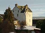 | |||
| Kincarrathie Doocot | 56°24′25″N 3°25′22″W | Category B | 39351 | | |||
| Atholl Street 4 (N. Side) | 56°23′59″N 3°25′56″W | Category B | 39361 | | |||
| Barossa Place 25 And 5 Hay Street | 56°24′03″N 3°26′07″W | Category B | 39378 | | |||
| 18 Charlotte Street | 56°23′55″N 3°25′43″W | Category B | 39400 | | |||
| Dundee Road Bellwood Cottage | 56°23′36″N 3°25′13″W | Category C(S) | 39419 | | |||
| Dundee Road Barnhill Tollhouse | 56°22′57″N 3°24′49″W | Category A | 39422 | | |||
| Kinnoul Parish Church, Dundee Road | 56°23′45″N 3°25′21″W | Category B | 39304 | | |||
| St Matthew's (Formerly West) Church, Tay Street | 56°23′46″N 3°25′35″W | Category B | 39312 | | |||
| Hospital Street, King Street And Albert Place, Former King James Vi Hospital Including Boundary Walls | 56°23′41″N 3°26′06″W | Category A | 39319 | .jpg) | |||
| The Old Academy, 6, 7 Rose Terrace | 56°24′01″N 3°25′57″W | Category A | 39322 | | |||
| Glasgow Road, West Woodlands, Coach House | 56°23′21″N 3°28′18″W | Category C(S) | 50826 | | |||
| 5 And 7 King Street, Including St Andrew Lodge | 56°23′42″N 3°26′03″W | Category C(S) | 51364 | | |||
| 60 And 62 Princes Street | 56°23′35″N 3°25′41″W | Category C(S) | 51367 | | |||
| 2-16 (Even Nos) North Methven Street And 54 And 56 West Mill Street | 56°23′52″N 3°26′06″W | Category C(S) | 51378 | | |||
| 37-43 Scott Street And 141 And 143 South Street | 56°23′43″N 3°25′57″W | Category C(S) | 51640 | | |||
| South Street, 89-95 (N. Side) (Odd Numbers) | 56°23′43″N 3°25′50″W | Category B | 39641 | | |||
| South Street 26-32 (S. Side) (Even Numbers) | 56°23′42″N 3°25′39″W | Category B | 39645 | | |||
| 30-36 South Street, Salutation Hotel | 56°23′42″N 3°25′40″W | Category B | 39646 | | |||
| 220 South Street And 17 Canal Crescent | 56°23′43″N 3°26′03″W | Category B | 39648 | | |||
| Stormont Street, 8 | 56°24′00″N 3°26′01″W | Category C(S) | 39653 | | |||
| 62-72 (Even Nos) Tay Street, Including Former Museum | 56°23′37″N 3°25′35″W | Category B | 39658 | | |||
| Watergate, 21-31 (Odd Numbers) | 56°23′47″N 3°25′37″W | Category C(S) | 39661 | | |||
| Melville Street, 7-11 (Odd Numbers) | 56°23′59″N 3°26′05″W | Category C(S) | 39555 | | |||
| Melville Street 26 | 56°24′01″N 3°26′11″W | Category C(S) | 39561 | | |||
| Melville Street 26 Domestic Building At Rear Of Above | 56°24′01″N 3°26′11″W | Category C(S) | 39562 | | |||
| 37-41 (Odd Nos) North Methven Street | 56°23′55″N 3°26′04″W | Category C(S) | 39565 | | |||
| West Mill Street, Lower City Mills, Tourist Information Centre | 56°23′51″N 3°26′08″W | Category A | 39578 |  | |||
| 55 Princes Street, Greyfriars House | 56°23′38″N 3°25′46″W | Category C(S) | 39591 | | |||
| Rose Terrace, 13-16 (All Numbers) | 56°24′03″N 3°25′59″W | Category B | 39598 | | |||
| St John's Place, 9, 10 | 56°23′46″N 3°25′43″W | Category B | 39603 | | |||
| St John Street (W. Side) 7-13 (Odd Numbers) | 56°23′47″N 3°25′40″W | Category B | 39605 | | |||
| St John Street (W Side) 35-39 (Odd Numbers) | 56°23′43″N 3°25′40″W | Category B | 39610 | | |||
| St John Street (E. Side) 10-16 (Even Numbers) | 56°23′47″N 3°25′38″W | Category B | 39612 | | |||
| St John Street, (E. Side) 42, 44 | 56°23′45″N 3°25′38″W | Category B | 39617 | | |||
| St John Street, (E. Side) 58, 60 | 56°23′44″N 3°25′38″W | Category B | 39619 | | |||
| 5 St Leonard's Bank, Including Boundary Walls And Outbuilding | 56°23′28″N 3°26′12″W | Category B | 39626 | | |||
| George Street 22, 24 (W Side) Bank Of Scotland Buildings, (Formerly The Union Bank) | 56°23′50″N 3°25′40″W | Category B | 39446 | | |||
| George Street 50, 52 (W Side) | 56°23′52″N 3°25′41″W | Category C(S) | 39450 | | |||
| 177-187 (Odd Numbers) High Street, Perth Theatre | 56°23′49″N 3°25′55″W | Category B | 39468 | | |||
| High Street And Corner Of Tay Street, General Accident Fire And Life Assurance Corporation, World Headquarters | 56°23′48″N 3°25′34″W | Category B | 39469 | | |||
| High Street 70-74 (S Side) (Even Numbers) | 56°23′47″N 3°25′43″W | Category B | 39476 | | |||
| Isla Road Boatlands | 56°24′24″N 3°25′37″W | Category B | 39486 | | |||
| 35-49 (Odd Nos) Kinnoull Street, 1 Mill Street, Union Street (South Side) Former Pullars Dyeworks | 56°23′52″N 3°25′54″W | Category B | 39526 | | |||
| Kinnoul Terrace Craigievar And Darnick | 56°23′49″N 3°25′12″W | Category B | 39536 | | |||
| Main Street 2-16 (Even Numbers) And 2 West Bridge Street, Bridgend | 56°23′58″N 3°25′25″W | Category C(S) | 39541 | | |||
| Gatehouse | 56°23′08″N 3°25′51″W | Category C(S) | 39330 | | |||
| Kinnoul Primary School, Dundee Road | 56°23′45″N 3°25′16″W | Category C(S) | 39343 | | |||
| Bellwood, Off Dundee Road | 56°23′30″N 3°24′59″W | Category B | 39347 | | |||
| Atholl Crescent, 1 | 56°23′41″N 3°25′50″W | Category B | 39353 | | |||
| Atholl Street, 1, 3, (S. Side) | 56°23′58″N 3°25′56″W | Category B | 39357 | | |||
| Atholl Street 56 (N. Side) | 56°23′58″N 3°26′07″W | Category C(S) | 39367 | | |||
| Atholl Street 58-66 (N. Side) (Even Numbers) | 56°23′58″N 3°26′08″W | Category B | 39368 | | |||
| Barossa Place 13 | 56°24′04″N 3°26′02″W | Category B | 39373 | | |||
| Barossa Place 15, 17 | 56°24′04″N 3°26′04″W | Category C(S) | 39374 | | |||
| Barossa Street 26-56 (Even Nos) | 56°24′02″N 3°26′01″W | Category C(S) | 39385 | | |||
| Blackfriars Street 8, 10 | 56°23′56″N 3°25′51″W | Category C(S) | 39387 | | |||
| Bowerswell Road Bankhead | 56°23′52″N 3°25′15″W | Category B | 39390 | | |||
| Charlotte Street, 9-13 (Odd Numbers) | 56°23′56″N 3°25′43″W | Category B | 39397 | | |||
| Edinburgh Road 79, Old Tollhouse | 56°22′33″N 3°25′45″W | Category C(S) | 39426 | | |||
| George Street 5-9 (E Side) (Odd Numbers) | 56°23′50″N 3°25′37″W | Category B | 39432 | | |||
| Middle Church, (Formerly) And Halls, 4, 6 Tay Street | 56°23′51″N 3°25′36″W | Category B | 39305 | | |||
| Princes Street, St John The Baptist (Episcopal) Church | 56°23′38″N 3°25′40″W | Category B | 39308 | | |||
| Municipal Buildings, 1, 3, 5 High Street, 8, 10, 11, 12, 13, 14, 15, 16, 18 Tay Street (One Continuous Design) | 56°23′49″N 3°25′34″W | Category B | 39320 | | |||
| 'H' Block 1, 2, 3 North Square | 56°23′10″N 3°25′54″W | Category B | 39327 | | |||
| Gleneagles Road, Friarton Quarry, St Magdalene's Gunpowder Magazine | 56°22′29″N 3°26′14″W | Category B | 51054 | | |||
| Scott Street, Perth Methodist Church | 56°23′42″N 3°25′58″W | Category C(S) | 51368 | | |||
| 284 And 286 High Street And 7 Lickley Street, Peddie's Building | 56°23′49″N 3°26′17″W | Category C(S) | 51398 | | |||
| Kinnoull Street, Perth Congregational Church | 56°23′52″N 3°25′59″W | Category B | 51639 | | |||
| South Street, 29-37 (N. Side) (Odd Numbers) | 56°23′43″N 3°25′41″W | Category B | 39637 | | |||
| 38 South Street And 2 Princes Street (Former Commercial Bank) | 56°23′42″N 3°25′41″W | Category B | 39647 | | |||
| 17-21 (Odd Nos) Speygate | 56°23′41″N 3°25′37″W | Category C(S) | 39651 | | |||
| Main Street, 1-5 Bridgend (Odd Numbers) | 56°23′58″N 3°25′23″W | Category C(S) | 39548 | | |||
| Main Street, Ardchoille, (Formerly Rosemount) Now Perth And Kinross District Police Headquarters | 56°24′04″N 3°25′17″W | Category B | 39550 | | |||
| Melville Street, 1, 3 | 56°23′58″N 3°26′04″W | Category C(S) | 39554 | | |||
| Melville Street 23 Scottish Milk Marketing Board Regional Office | 56°24′00″N 3°26′07″W | Category B | 39557 | | |||
| Melville Street 24 Struanbank | 56°24′01″N 3°26′11″W | Category C(S) | 39560 | | |||
| 61-71 (Odd Nos) South Methven Street | 56°23′44″N 3°26′05″W | Category B | 39573 | | |||
| Muirhall Road Pitcullen House, Part Of Murray Royal Hospital | 56°24′01″N 3°25′04″W | Category B | 39583 | | |||
| Murray Street, Playhouse Cinema | 56°23′53″N 3°26′01″W | Category B | 39584 | | |||
| Rose Terrace, 17 | 56°24′03″N 3°25′59″W | Category B | 39599 | | |||
| St John Street (E. Side) 18-24 (Even Numbers) | 56°23′47″N 3°25′38″W | Category B | 39613 | | |||
| St John Street, (E. Side) 48, 50, Bank Of Scotland Formerly Central Bank Buildings | 56°23′45″N 3°25′38″W | Category A | 39618 | | |||
| St John Street, (E. Side) 62-70 (Even Numbers) | 56°23′43″N 3°25′39″W | Category B | 39620 | | |||
| 1 And 2 St Leonard's Bank, Parklands Hotel | 56°23′31″N 3°26′11″W | Category C(S) | 39622 | | |||
| George Street 67-71 (E Side) (Odd Numbers) | 56°23′54″N 3°25′40″W | Category C(S) | 39442 | | |||
| George Street 75, 77 (E Side) Bank Of Scotland | 56°23′54″N 3°25′39″W | Category B | 39443 | | |||
| George Street 26-34 (W Side) (Even Numbers) | 56°23′50″N 3°25′40″W | Category B | 39447 | | |||
| George Street (W Side) 80 And 2 Charlotte Street | 56°23′55″N 3°25′41″W | Category B | 39453 | | |||
| High Street 55, 57 (N Side) | 56°23′49″N 3°25′42″W | Category B | 39467 | | |||
| High Street 44, 46 (S Side) And 1 St John Street | 56°23′48″N 3°25′40″W | Category B | 39472 | | |||
| High Street 86-96 (S Side) (Even Numbers) | 56°23′48″N 3°25′45″W | Category B | 39479 | | |||
| High Street 98-102 (S Side) (Even Numbers) | 56°23′48″N 3°25′46″W | Category B | 39480 | | |||
| 1-3 (Inclusive Nos) King's Place And 1-3 (Inclusive Nos) King James Place And 55 And 57 King Street And Boundary Wall | 56°23′33″N 3°26′01″W | Category B | 39502 | | |||
| 6 King's Place, Pedigree House | 56°23′32″N 3°26′06″W | Category B | 39504 | | |||
| 3 King Street And 32 Canal Crescent | 56°23′42″N 3°26′03″W | Category B | 39505 | | |||
| 1 And 2 Graham's Place, King Street, Including Boundary Walls | 56°23′39″N 3°26′02″W | Category B | 39506 | | |||
| 41 And 43 King Street, Including Boundary Walls | 56°23′35″N 3°26′02″W | Category C(S) | 39511 | | |||
| 48 And 50 Kinnoull Street | 56°23′57″N 3°25′59″W | Category C(S) | 39530 | | |||
| 14-16 (Even Nos) Kinnoull Street (Former Sandeman Library) | 56°23′51″N 3°25′58″W | Category C(S) | 39334 | | |||
| Kincarrathie House, Former 'Chapel' | 56°24′20″N 3°25′20″W | Category B | 39349 | | |||
| 11-17 (Odd Nos) Atholl Street | 56°23′58″N 3°26′01″W | Category B | 39359 | | |||
| Atholl Street 26-30 (N Side) (Even Numbers) | 56°23′58″N 3°26′00″W | Category C(S) | 39365 | | |||
| Barossa Place, 7 | 56°24′05″N 3°26′00″W | Category B | 39370 | | |||
| Barossa Place 21 | 56°24′03″N 3°26′05″W | Category C(S) | 39376 | | |||
| Barossa Place 14, 16, 18 | 56°24′02″N 3°26′04″W | Category B | 39383 | | |||
| Barossa Place 22, 24 | 56°24′01″N 3°26′07″W | Category B | 39384 | | |||
| Charlotte Street, 10-14 (Even Numbers) | 56°23′55″N 3°25′42″W | Category B | 39399 | | |||
| 25 Dundee Road, Dalvay And Lower Dalvay, Formerly Manse Of St Mark's | 56°23′48″N 3°25′20″W | Category C(S) | 39413 | | |||
| Dundee Road Roma | 56°23′36″N 3°25′13″W | Category C(S) | 39418 | | |||
| George Street 11, 13 (E Side) | 56°23′50″N 3°25′37″W | Category B | 39433 | | |||
| George Street 47-51 (E Side) Royal George Hotel (Odd Numbers) | 56°23′53″N 3°25′38″W | Category B | 39439 | | |||
| Kinnoul Old Churchyard Or Graveyard, Dundee Road | 56°23′38″N 3°25′20″W | Category C(S) | 39303 | | |||
| Murray Royal Asylum Muirhall Road Main Building And Chapel Only | 56°24′03″N 3°24′47″W | Category B | 39321 | | |||
| Tay Street, Sheriff Court | 56°23′40″N 3°25′34″W | Category A | 39325 | 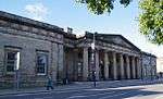 | |||
| Bowerswell Lane, Bowerswell Summerhouse, Including Greenhouse And Boundary Wall | 56°23′53″N 3°25′04″W | Category C(S) | 47282 | | |||
| Dundee Road, 2 Hillside, Ferndale Including Boundary Walls With Inset Railings And Gates | 56°23′29″N 3°25′15″W | Category B | 47317 | | |||
| 18 And 20 York Place | 56°23′43″N 3°26′23″W | Category C(S) | 50808 | | |||
| Atholl Street, Former St Andrews Church | 56°23′57″N 3°26′03″W | Category C(S) | 51637 | | |||
| 7 St Leonard's Bank, Including Boundary Walls And Outbuildings | 56°23′27″N 3°26′13″W | Category B | 39628 | | |||
| St Magdalene's Road, 21 Southesk Bank | 56°23′08″N 3°26′26″W | Category C(S) | 39632 | | |||
| South Street, 7 (N. Side) | 56°23′43″N 3°25′37″W | Category B | 39634 | | |||
| Tay Street, 2 | 56°23′54″N 3°25′38″W | Category C(S) | 39654 | | |||
| Main Street Springbank Bridgend (Divided Into 3 Flats) | 56°24′06″N 3°25′30″W | Category B | 39547 | | |||
| Melville Street Presbytery Of St John's Rc Church | 56°24′00″N 3°26′10″W | Category C(S) | 39559 | | |||
| 55-63 (Odd Nos) North Methven Street | 56°23′56″N 3°26′04″W | Category C(S) | 39568 | | |||
| West Mill Street, The Old Granary | 56°23′52″N 3°26′09″W | Category B | 39579 | | |||
| North Port, Hydro Electric Board Office, Formerly Blackfriars House | 56°23′55″N 3°25′47″W | Category B | 39587 | | |||
| 50 Princes Street | 56°23′36″N 3°25′41″W | Category C(S) | 39594 | | |||
| Rose Terrace And 2 Atholl Street Corner House | 56°23′59″N 3°25′56″W | Category B | 39595 | | |||
| 4 St Leonard's Bank, Including Boundary Walls | 56°23′29″N 3°26′12″W | Category C(S) | 39625 | | |||
| Glasgow Road Hamilton House Now Syha | 56°23′35″N 3°27′12″W | Category B | 39455 | | |||
| High Street 13-19 (N. Side) (Odd Numbers) | 56°23′49″N 3°25′36″W | Category B | 39462 | | |||
| High Street 28, 30 (S Side) And 1-5 Watergate (Odd Numbers) | 56°23′48″N 3°25′37″W | Category B | 39470 | | |||
| High Street 76, 78 (S Side) | 56°23′47″N 3°25′44″W | Category C(S) | 39477 | | |||
| 44 And 46 James Street | 56°23′34″N 3°26′00″W | Category C(S) | 39495 | | |||
| Keir Street Croft House | 56°24′11″N 3°25′24″W | Category C(S) | 39501 | | |||
| 35 King Street, Including Boundary Walls | 56°23′37″N 3°26′02″W | Category C(S) | 39508 | | |||
| Kinnoul Street, 75 (E. Side) | 56°23′57″N 3°25′57″W | Category C(S) | 39527 | | |||
| Kinnoul Terrace Murrayville | 56°23′49″N 3°25′16″W | Category C(S) | 39533 | | |||
| Kinnoul Terrace Witchhill House | 56°23′47″N 3°25′17″W | Category B | 39535 | | |||
| Canal Street And Tay Street, Greyfriars Burial Ground Including Gates And Boundary Walls | 56°23′36″N 3°25′38″W | Category A | 39338 | 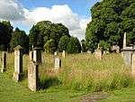 | |||
| Perth Bridge Over River Tay | 56°23′56″N 3°25′31″W | Category A | 39339 | 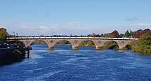 | |||
| Tay Street, Former Perth Water Works | 56°23′32″N 3°25′35″W | Category A | 39341 | 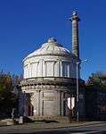 | |||
| Barossa Place 19, 19A | 56°24′04″N 3°26′04″W | Category B | 39375 | | |||
| Barossa Place 23 | 56°24′03″N 3°26′06″W | Category B | 39377 | | |||
| Barossa Place 31 Perth And Kinross District Social Work Department | 56°24′02″N 3°26′10″W | Category B | 39381 | | |||
| Blackfriars Street 4 | 56°23′57″N 3°25′50″W | Category C(S) | 39386 | | |||
| Charlotte Street, 4-8 (Even Numbers) | 56°23′55″N 3°25′42″W | Category B | 39398 | | |||
| Curfew Row, Building On Site Of Town House Of Lord John Murray | 56°23′54″N 3°25′48″W | Category B | 39409 | | |||
| Dundee Road Glensaugh | 56°23′53″N 3°25′18″W | Category B | 39411 | | |||
| Dundee Road Wellbank | 56°23′39″N 3°25′16″W | Category C(S) | 39416 | | |||
| Fairmount Terrace Balnacraig | 56°23′20″N 3°25′00″W | Category B | 39429 | | |||
| George Street 41-45 (E Side) (Odd Numbers) | 56°23′52″N 3°25′39″W | Category C(S) | 39438 | | |||
| Mill Street, North Church (Church Of Scotland), Including Former Church Session House To Rear | 56°23′51″N 3°25′59″W | Category B | 39306 | | |||
| St John's Rc Church Melville Street | 56°24′00″N 3°26′09″W | Category C(S) | 39307 | | |||
| South Methven Street, High Street And St Paul's Square, St Paul's Church | 56°23′48″N 3°26′05″W | Category B | 39315 | | |||
| Art Gallery And Museum, George Street | 56°23′54″N 3°25′43″W | Category B | 39317 | | |||
| Perth Prison Edinburgh Road 'A' Block 18, 19 South Square | 56°23′10″N 3°25′54″W | Category B | 39326 | | |||
| Pomarium Street, Free Presbyterian Church Of Scotland, Including Adjoining Flat | 56°23′39″N 3°26′11″W | Category C(S) | 51365 | | |||
| 16 And 18 Methven Street | 56°23′48″N 3°26′03″W | Category B | 51641 | | |||
| South Street 55, 57 And 59 (N. Side) | 56°23′43″N 3°25′44″W | Category B | 39639 | | |||
| 8-12 (Even Nos) South Street And 3 Speygate | 56°23′42″N 3°25′37″W | Category B | 39643 | | |||
| Main Street, 7, 9,11 Bridgend | 56°23′59″N 3°25′23″W | Category C(S) | 39549 | | |||
| Melville Street, 25 Santa Monica | 56°24′01″N 3°26′08″W | Category B | 39558 | | |||
| 33 North Methven Street | 56°23′54″N 3°26′04″W | Category C(S) | 39564 | | |||
| 31 South Methven Street | 56°23′48″N 3°26′05″W | Category B | 39572 | | |||
| West Mill Street, Ramada Perth Hotel, (Former Upper City Mills) | 56°23′51″N 3°26′12″W | Category A | 39577 | | |||
| Muirhall Road, Annat Lodge | 56°23′54″N 3°24′59″W | Category B | 39581 | | |||
| 7 North William Street | 56°23′57″N 3°26′01″W | Category C(S) | 39588 | | |||
| St John's Place, 3 | 56°23′46″N 3°25′40″W | Category B | 39600 | | |||
| St John Street, (W. Side) 17-23 (Odd Numbers) | 56°23′46″N 3°25′40″W | Category B | 39607 | | |||
| St John Street, 72-76 (E. Side) (Even Numbers) | 56°23′43″N 3°25′38″W | Category B | 39621 | | |||
| 3 St Leonard's Bank, Including Boundary Walls And Gatepiers | 56°23′30″N 3°26′12″W | Category B | 39624 | | |||
| George Street 53-57 (E Side) (Odd Numbers) | 56°23′53″N 3°25′39″W | Category C(S) | 39440 | | |||
| George Street 59-65 (E Side) (Odd Numbers) | 56°23′53″N 3°25′39″W | Category C(S) | 39441 | | |||
| George Street 12, 14 (W Side) | 56°23′49″N 3°25′39″W | Category C(S) | 39444 | | |||
| George Street 36, 38 (W Side) Glovers Hall | 56°23′51″N 3°25′40″W | Category C(S) | 39448 | | |||
| George Street 54-60 (W Side) (Even Numbers) | 56°23′52″N 3°25′41″W | Category C(S) | 39451 | | |||
| High Street 48, 50 (S Side) | 56°23′48″N 3°25′40″W | Category B | 39473 | | |||
| High Street 108-112 (Even Numbers) (S. Side) And 2-8 King Edward Street (Even Numbers) | 56°23′47″N 3°25′47″W | Category B | 39482 | | |||
| Isla Road Tayfletts | 56°24′12″N 3°25′29″W | Category B | 39484 | | |||
| Isla Road Upper Springlands Garden House And Garden Walls | 56°24′34″N 3°25′43″W | Category C(S) | 39491 | | |||
| Jeanfield Road Cornhill House Now Offices | 56°23′50″N 3°27′29″W | Category B | 39500 | | |||
| 4 Kinnoull Street And 197 High Street | 56°23′49″N 3°25′58″W | Category B | 39528 | | |||
| 52 Kinnoull Street And 9 Atholl Street | 56°23′57″N 3°25′59″W | Category B | 39531 | | |||
| Kinnoul Terrace The Den, Offices Of John Maclaren And Russell Diplock, Architects And Planning Consultants | 56°23′50″N 3°25′16″W | Category C(S) | 39532 | | |||
| Former Governor's House, 5 North Square | 56°23′09″N 3°25′53″W | Category B | 39328 | | |||
| Atholl Crescent, 2-8 (All Numbers) | 56°23′58″N 3°25′53″W | Category A | 39354 | | |||
| 1-3 Atholl Court (Formerly 6-12 Atholl Street) | 56°23′58″N 3°25′57″W | Category B | 39362 | | |||
| Atholl Street 20-24 (N Side) (Even Numbers) | 56°23′58″N 3°25′59″W | Category C(S) | 39364 | | |||
| Bowerswell Road Bowerswell | 56°23′51″N 3°25′06″W | Category B | 39388 | | |||
| Bowerswell Road Pennylands | 56°23′53″N 3°25′13″W | Category C(S) | 39389 | | |||
| Charlotte Street 3 (N Side) | 56°23′56″N 3°25′40″W | Category B | 39394 | | |||
| Charlotte Street, 5 | 56°23′56″N 3°25′41″W | Category B | 39395 | | |||
| Charlotte Street, 7 | 56°23′56″N 3°25′42″W | Category B | 39396 | | |||
| Craigie Place, 19 Craigiebank | 56°23′08″N 3°26′24″W | Category C(S) | 39406 | | |||
| Craigie Road Craigiepark | 56°23′05″N 3°26′17″W | Category C(S) | 39407 | | |||
| Crieff Road 23 Balhousie Toll | 56°24′17″N 3°27′08″W | Category C(S) | 39408 | | |||
| Fairmount Terrace Willanslee | 56°23′25″N 3°25′01″W | Category C(S) | 39428 | | |||
| George Street 23-27 (E Side) (Odd Numbers) | 56°23′51″N 3°25′38″W | Category B | 39435 | | |||
| George Street 29-33 (E Side) (Odd Numbers) | 56°23′51″N 3°25′38″W | Category B | 39436 | | |||
| St Mary's Monastery (Rc), Hatton Road | 56°23′41″N 3°24′35″W | Category B | 39311 | | |||
| City Hall, King Edward Street, St John's Place And Kirkside | 56°23′45″N 3°25′46″W | Category B | 39318 | 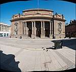 | |||
| 4 York Place, The Lodge, Including Gatepiers | 56°23′43″N 3°26′12″W | Category B | 39324 | | |||
| York Place, Trinity Church Of The Nazarene, Including Boundary Wall And Gatepiers | 56°23′45″N 3°26′16″W | Category C(S) | 51362 | | |||
| South Street, 11-15 (N. Side) (Odd Numbers) | 56°23′43″N 3°25′38″W | Category B | 39635 | | |||
| 189 South Street And 70 South Methven Street | 56°23′44″N 3°26′03″W | Category B | 39642 | | |||
| 22 South William Street | 56°23′34″N 3°25′47″W | Category C(S) | 39649 | | |||
| Muirhall Road Annat Lodge Stableyard | 56°23′56″N 3°25′01″W | Category C(S) | 39582 | | |||
| 43 Princes Street, Dunbar | 56°23′39″N 3°25′45″W | Category C(S) | 39590 | | |||
| St John's Place, 5, 6, 7 & 8 | 56°23′46″N 3°25′42″W | Category C(S) | 39602 | | |||
| St John Street, 25 1, 3 5 South St John's Place | 56°23′44″N 3°25′40″W | Category B | 39608 | | |||
| St John Street, (E. Side) 32-36 (Even Numbers) | 56°23′46″N 3°25′38″W | Category B | 39615 | | |||
| St John Street, (E. Side) 38, 40 | 56°23′46″N 3°25′38″W | Category B | 39616 | | |||
| George Street 40-48 (W Side) (Even Numbers) | 56°23′51″N 3°25′40″W | Category C(S) | 39449 | | |||
| High Street 7, 9, 11 (N. Side) Royal Bank Of Scotland | 56°23′49″N 3°25′36″W | Category B | 39461 | | |||
| High Street 32, 34, 36 And 36A (S Side) | 56°23′48″N 3°25′38″W | Category B | 39471 | | |||
| High Street 60, 62 (S Side) | 56°23′48″N 3°25′42″W | Category B | 39474 | | |||
| High Street 104, 106 (S. Side) Guildhall | 56°23′48″N 3°25′47″W | Category B | 39481 | | |||
| Isla Road Springland | 56°24′31″N 3°25′44″W | Category B | 39488 | | |||
| 4 And 5 King's Place | 56°23′33″N 3°26′05″W | Category B | 39503 | | |||
| 16 King Street, Including Boundary Walls | 56°23′38″N 3°26′05″W | Category C(S) | 39518 | | |||
| Kinnoul Terrace Somerset | 56°23′47″N 3°25′13″W | Category C(S) | 39537 | | |||
| Leonard Street, Station Hotel, Including Gatepiers | 56°23′34″N 3°26′21″W | Category B | 39538 | | |||
| Perth Northern District Primary School, Dunkeld Road And Muirton Place | 56°24′02″N 3°26′16″W | Category B | 39344 | | |||
| Kincarrathie House, Old People's Home. (Gannochy Trust) Isla Road And Pitcullen Crescent | 56°24′23″N 3°25′23″W | Category B | 39348 | | |||
| Atholl Street 32-36 (N. Side) (Even Numbers) | 56°23′59″N 3°26′01″W | Category C(S) | 39366 | | |||
| Charlotte Place 2-4, And 20 Charlotte Street | 56°23′55″N 3°25′44″W | Category A | 39392 | | |||
| 1 Charterhouse Lane And 2 And 4 Canal Crescent | 56°23′40″N 3°26′00″W | Category C(S) | 39401 | | |||
| Craigie Place, 17, Earlybank | 56°23′09″N 3°26′24″W | Category B | 39405 | | |||
| Curfew Row Fair Maid's House | 56°23′54″N 3°25′48″W | Category B | 39410 |  | |||
| Dundee Road Kinnoul Cottage | 56°23′46″N 3°25′20″W | Category B | 39412 | | |||
| Dundee Road Knowehead | 56°23′49″N 3°25′20″W | Category B | 39414 | | |||
| Dundee Road Rio (Abbeyfield Society Old People's Home) | 56°23′43″N 3°25′17″W | Category B | 39415 | | |||
| Dundee Road St Leonard's Manse | 56°23′19″N 3°25′07″W | Category B | 39420 | | |||
| George Street 35-39 (E Side) (Odd Numbers) | 56°23′52″N 3°25′39″W | Category C(S) | 39437 | | |||
| Kinnoul Aisle, Kinnoul Old Churchyard Or Graveyard, Dundee Road | 56°23′38″N 3°25′20″W | Category A | 39302 |  | |||
| Marshall Place, St Leonard's-In-The-Fields Church And Halls (Church Of Scotland), Including Boundary Wall And Gatepiers | 56°23′33″N 3°25′59″W | Category A | 39310 | .jpg) | |||
| St Matthew's Hall And Church Officer's House, 34 Watergate | 56°23′47″N 3°25′35″W | Category C(S) | 39313 | | |||
| Atholl Street And North Methven Street, St Ninian's Cathedral (Scottish Episcopal Church) | 56°23′57″N 3°26′09″W | Category A | 39314 | | |||
| 170-178 (Even Nos) South Street, Former Wesleyan Chapel | 56°23′42″N 3°25′58″W | Category C(S) | 39316 | | |||
| York Place, A K Bell Library Including Boundary Wall To York Place | 56°23′42″N 3°26′15″W | Category A | 39323 | | |||
| Caledonian Road, Caledonian Road Primary School Including Advanced Department Building, Wrought Iron Railings And Gates | 56°23′40″N 3°26′19″W | Category B | 50510 | 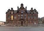 | |||
| 97 Canal Street, Mucky Mulligan's | 56°23′40″N 3°25′59″W | Category C(S) | 51363 | | |||
| 9 St Leonard's Bank, Including Boundary Walls | 56°23′25″N 3°26′14″W | Category C(S) | 39630 | | |||
| South Street, 17-21 (N. Side) (Odd Numbers) | 56°23′43″N 3°25′38″W | Category B | 39636 | | |||
| Tay Street, 46-52 "Gowrie House" (Even Numbers) | 56°23′43″N 3°25′33″W | Category B | 39657 | | |||
| West Bridge Street, 1, 3 Bridgend | 56°23′57″N 3°25′24″W | Category C(S) | 39663 | | |||
| 113-119 (Odd Nos) Glover Street | 56°23′35″N 3°26′36″W | Category B | 39667 | | |||
| Main Street Inchbank Bridgend | 56°24′01″N 3°25′25″W | Category B | 39542 | | |||
| Main Street Earnoch Bridgend | 56°24′05″N 3°25′29″W | Category B | 39546 | | |||
| Melville Street, 15, 17 | 56°23′59″N 3°26′06″W | Category C(S) | 39556 | | |||
| Melville Street 28-32 (Even Numbers) And 1 Low Street | 56°24′01″N 3°26′11″W | Category C(S) | 39563 | | |||
| Methven Street, (North) 43-47 (Odd Numbers) | 56°23′55″N 3°26′04″W | Category C(S) | 39566 | | |||
| North Port, 8 - 16 (Even Numbers) | 56°23′54″N 3°25′45″W | Category B | 39586 | | |||
| 38-48 (Even Nos) Princes Street | 56°23′36″N 3°25′41″W | Category C(S) | 39593 | | |||
| Glasgow Road Rosslyn House | 56°23′43″N 3°26′46″W | Category C(S) | 39454 | | |||
| Glasgow Road, 107 Hamilton House Lodge | 56°23′36″N 3°27′04″W | Category C(S) | 39456 | | |||
| High Street 64-68 (S Side) (Even Numbers) | 56°23′47″N 3°25′42″W | Category B | 39475 | | |||
| Isla Road Rose Cottage | 56°24′10″N 3°25′24″W | Category C(S) | 39483 | | |||
| Kinnoul Street 25, 27 (E Side) | 56°23′50″N 3°25′56″W | Category C(S) | 39524 | | |||
| Kinnoul Terrace Gaskhill | 56°23′48″N 3°25′16″W | Category C(S) | 39534 | | |||
| Original Perimeter Wall Enclosing Canal S And Se Of C And D Blocks | 56°23′04″N 3°25′42″W | Category B | 39332 | | |||
| 6 And 8 South Methven Street (Former Sharp's Institute) | 56°23′49″N 3°26′01″W | Category B | 39335 | | |||
| Atholl Street, 5, 7, (S. Side) And 77 Kinnoul Street | 56°23′57″N 3°25′57″W | Category B | 39358 | | |||
| 19 Atholl Street And 18 North William Street | 56°23′58″N 3°26′02″W | Category C(S) | 39360 | | |||
| Barossa Place, 9 | 56°24′04″N 3°26′01″W | Category B | 39371 | | |||
| Barossa Place 29 | 56°24′02″N 3°26′09″W | Category C(S) | 39380 | | |||
| Charlotte Street 1 (N Side) | 56°23′56″N 3°25′40″W | Category B | 39393 | | |||
| Commercial Street 1, 3 Bridgend | 56°23′57″N 3°25′24″W | Category C(S) | 39402 | | |||
| 2 And 4 County Place And 1 Hospital Street | 56°23′43″N 3°26′06″W | Category B | 39403 | | |||
| 6 And 8 County Place And 3 And 5 Hospital Street | 56°23′43″N 3°26′06″W | Category B | 39404 | | |||
| St John's Kirk, Kirkside, St John's Place, St John Street | 56°23′45″N 3°25′41″W | Category A | 39300 | 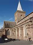 | |||
| 251 High Street | 56°23′49″N 3°26′06″W | Category B | 39301 | | |||
| 52-54 Canal Street, Love's Auction Rooms | 56°23′38″N 3°25′48″W | Category B | 50620 | | |||
| 15-19 (Odd Nos) Princes Street | 56°23′41″N 3°25′42″W | Category C(S) | 51366 | | |||
| 46-50 (Even Nos) South Street | 56°23′42″N 3°25′43″W | Category C(S) | 51369 | | |||
| 226-232 (Even Nos) High Street | 56°23′48″N 3°26′03″W | Category C(S) | 51638 | |
Key
The scheme for classifying buildings in Scotland is:
- Category A: "buildings of national or international importance, either architectural or historic; or fine, little-altered examples of some particular period, style or building type."[1]
- Category B: "buildings of regional or more than local importance; or major examples of some particular period, style or building type, which may have been altered."[1]
- Category C: "buildings of local importance; lesser examples of any period, style, or building type, as originally constructed or moderately altered; and simple traditional buildings which group well with other listed buildings."[1]
In March 2016 there were 47,288 listed buildings in Scotland. Of these, 8 per cent were Category A, and 50 per cent were Category B, with the rest listed at Category C.[2]
Notes
- Sometimes known as OSGB36, the grid reference (where provided) is based on the British national grid reference system used by the Ordnance Survey.
• "Guide to National Grid". Ordnance Survey. Retrieved 2007-12-12.
• "Get-a-map". Ordnance Survey. Retrieved 2007-12-17. - Historic Environment Scotland assign a unique alphanumeric identifier to each designated site in Scotland, for listed buildings this always begins with "LB", for example "LB12345".
References
- All entries, addresses and coordinates are based on data from Historic Scotland. This data falls under the Open Government Licence
- "What is Listing?". Historic Environment Scotland. Retrieved 29 May 2018.
- Scotland's Historic Environment Audit 2016 (PDF). Historic Environment Scotland and the Built Environment Forum Scotland. pp. 15–16. Retrieved 29 May 2018.
This article is issued from Wikipedia. The text is licensed under Creative Commons - Attribution - Sharealike. Additional terms may apply for the media files.