List of listed buildings in Inchture, Perth and Kinross
List
| Name | Location | Date Listed | Grid Ref. [note 1] | Geo-coordinates | Notes | LB Number [note 2] | Image |
|---|---|---|---|---|---|---|---|
| Castlehill, Baledgarno | 56°27′37″N 3°10′35″W | Category B | 11759 |  | |||
| Smith, Filling Station And Scott Inchture Village | 56°26′44″N 3°10′05″W | Category C(S) | 11772 | | |||
| Post Office And House, Inchture Village | 56°26′45″N 3°10′08″W | Category C(S) | 11776 | | |||
| Inchture Lodge And Gates (Formerly To Rossie Priory | 56°27′47″N 3°09′46″W | Category B | 11784 | | |||
| The Cottage, Wester Ballindean | 56°26′58″N 3°12′18″W | Category C(S) | 11765 | | |||
| Crighton, Watson And 2 Vacant Houses, Inchture Village | 56°26′42″N 3°10′11″W | Category B | 11774 | | |||
| Inchture Hotel And Adjoining Cottage. Inchture Village | 56°26′42″N 3°10′17″W | Category C(S) | 11782 | | |||
| Rossie Church Within Rossie Priory Policies | 56°27′51″N 3°09′04″W | Category A | 11786 | | |||
| Baledgarno, N.W. Group Of Cottages, Baledgarno Mill. (Miller, Alcorn) | 56°27′30″N 3°10′33″W | Category B | 11791 | | |||
| Baledgarno, Steading | 56°27′29″N 3°10′35″W | Category C(S) | 11757 | | |||
| Burnside, Baledgarno | 56°27′26″N 3°10′30″W | Category B | 11758 | | |||
| Inchture School | 56°26′44″N 3°10′09″W | Category C(S) | 11777 | | |||
| Tighanrathad. (Runciman) Inchture Village | 56°26′44″N 3°10′12″W | Category C(S) | 11779 | | |||
| Ballindean Walled Garden | 56°27′15″N 3°11′26″W | Category B | 13463 | | |||
| Baledgarno, Farmhouse. (R. W. Wilson) | 56°27′28″N 3°10′37″W | Category B | 11756 | | |||
| New Cottage, Morven And Corner House, Inchture Village | 56°26′45″N 3°10′06″W | Category C(S) | 11775 | | |||
| Baledgarno, N.E. Group Of Cottages | 56°27′31″N 3°10′31″W | Category B | 11789 | 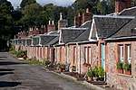 | |||
| The Knapp Rossie Estate Sawmill Stable | 56°28′19″N 3°10′27″W | Category B | 13318 | | |||
| The Knapp North Lodge | 56°28′24″N 3°10′56″W | Category B | 13319 | | |||
| Ballindean West Lodge | 56°27′04″N 3°12′09″W | Category B | 11763 | | |||
| Moncur Castle, Within Rossie Priory Policies | 56°27′09″N 3°09′50″W | Category B | 11785 | 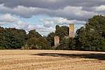 | |||
| Baledgarno, Footbridge Over Baledgarno Burn | 56°27′31″N 3°10′33″W | Category C(S) | 11793 | | |||
| Ballindean Steading | 56°27′15″N 3°11′35″W | Category B | 13480 | | |||
| Wester Ballindean Cottages | 56°27′00″N 3°12′20″W | Category B | 11766 | | |||
| Inchture Parish Church, Churchyard | 56°26′44″N 3°10′03″W | Category C(S) | 11771 | | |||
| Carselea (Logie) And Milne, Inchture Village | 56°26′44″N 3°10′11″W | Category B | 11778 | | |||
| Crossgates. Inchture Village | 56°26′36″N 3°10′27″W | Category B | 11783 | | |||
| Baledgarno, S.W. Group Of Cottages (Napier, J.Crichton | 56°27′28″N 3°10′34″W | Category C(S) | 11792 | | |||
| Inchmartine, Lodge House And Gatepiers | 56°26′08″N 3°11′40″W | Category B | 11767 | | |||
| Wester Ballindean Farmhouse | 56°27′00″N 3°12′23″W | Category C(S) | 12438 | | |||
| Ballindean House | 56°27′21″N 3°11′18″W | Category A | 11760 | .jpg) | |||
| Ballindean South Lodge And Gates, | 56°27′03″N 3°11′20″W | Category B | 11761 | | |||
| Inchture Parish Church | 56°26′44″N 3°10′03″W | Category B | 11770 | | |||
| Rose Cottage (Urquhart) And Mudie. Inchture Village | 56°26′43″N 3°10′06″W | Category C(S) | 11773 | | |||
| Market Cross, Old Rossie Within Rossie Priory Policies | 56°27′48″N 3°09′01″W | Category A | 11787 | | |||
| Rossie Priory | 56°27′50″N 3°09′42″W | Category B | 11788 | | |||
| The Knapp Rossie Estate Sawmill Seasoning Shed | 56°28′19″N 3°10′25″W | Category C(S) | 13317 | | |||
| Ballindean Nursery Lodge | 56°27′22″N 3°11′23″W | Category B | 11762 | | |||
| Easter Ballindean, Farmhouse | 56°27′15″N 3°11′35″W | Category C(S) | 11764 | | |||
| Baledgarno, S.E. Group Of Cottages | 56°27′28″N 3°10′26″W | Category B | 11790 | |
Key
The scheme for classifying buildings in Scotland is:
- Category A: "buildings of national or international importance, either architectural or historic; or fine, little-altered examples of some particular period, style or building type."[1]
- Category B: "buildings of regional or more than local importance; or major examples of some particular period, style or building type, which may have been altered."[1]
- Category C: "buildings of local importance; lesser examples of any period, style, or building type, as originally constructed or moderately altered; and simple traditional buildings which group well with other listed buildings."[1]
In March 2016 there were 47,288 listed buildings in Scotland. Of these, 8 per cent were Category A, and 50 per cent were Category B, with the rest listed at Category C.[2]
Notes
- Sometimes known as OSGB36, the grid reference (where provided) is based on the British national grid reference system used by the Ordnance Survey.
• "Guide to National Grid". Ordnance Survey. Retrieved 2007-12-12.
• "Get-a-map". Ordnance Survey. Retrieved 2007-12-17. - Historic Environment Scotland assign a unique alphanumeric identifier to each designated site in Scotland, for listed buildings this always begins with "LB", for example "LB12345".
References
- All entries, addresses and coordinates are based on data from Historic Scotland. This data falls under the Open Government Licence
- "What is Listing?". Historic Environment Scotland. Retrieved 29 May 2018.
- Scotland's Historic Environment Audit 2016 (PDF). Historic Environment Scotland and the Built Environment Forum Scotland. pp. 15–16. Retrieved 29 May 2018.
This article is issued from Wikipedia. The text is licensed under Creative Commons - Attribution - Sharealike. Additional terms may apply for the media files.