List of listed buildings in Orwell, Perth and Kinross
List
| Name | Location | Date Listed | Grid Ref. [note 1] | Geo-coordinates | Notes | LB Number [note 2] | Image |
|---|---|---|---|---|---|---|---|
| Hattonburn House | 56°14′06″N 3°24′35″W | Category C(S) | 19812 |  | |||
| Burleigh Farm | 56°13′31″N 3°24′21″W | Category B | 19054 | | |||
| Store (Old Free Church) Old Perth Road | 56°13′41″N 3°25′00″W | Category C(S) | 17634 | | |||
| Milnathort 13 Manse Road | 56°13′45″N 3°25′17″W | Category C(S) | 17635 | | |||
| The Cross, Town Hall | 56°13′37″N 3°25′12″W | Category B | 17638 | | |||
| 8-10 Back Loan | 56°13′38″N 3°25′09″W | Category B | 17639 | | |||
| South Street Former Milnathort Parish Church With Church Hall, Retaining Walls, Gatepiers And Gates | 56°13′34″N 3°25′15″W | Category B | 17656 | | |||
| 20-26 Wester Loan | 56°13′40″N 3°25′11″W | Category C(S) | 19810 | | |||
| Orwell Parish Kirk | 56°13′11″N 3°22′39″W | Category B | 17632 | | |||
| Collieston Farm-House And Steadings | 56°15′43″N 3°23′47″W | Category B | 17650 | | |||
| Burleigh Castle | 56°13′33″N 3°24′23″W | Category A | 17654 | 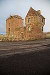 | |||
| Horn Of Thomanean Mausoleum Old Orwell Kirkyard | 56°13′11″N 3°22′38″W | Category C(S) | 17655 | | |||
| Ballingall Farm, New House | 56°13′33″N 3°26′49″W | Category B | 19261 | | |||
| Old Holton Farmhouse | 56°14′33″N 3°25′44″W | Category B | 17649 | | |||
| Milnathort, 2, 4 And 6 South Street | 56°13′36″N 3°25′13″W | Category C(S) | 49531 | | |||
| Hattonburn House, Former Coach House | 56°14′08″N 3°24′39″W | Category C(S) | 43208 | | |||
| Thomanean Barn, Horsemill And Cartsheds | 56°13′16″N 3°28′00″W | Category C(S) | 19811 | | |||
| Mill House 2 Stirling Road | 56°13′37″N 3°25′16″W | Category C(S) | 17644 | | |||
| Hilton House | 56°13′30″N 3°26′18″W | Category B | 17645 | | |||
| Milnathort, South Street, Royal Hotel Including Ancillary Structures | 56°13′35″N 3°25′14″W | Category B | 49532 | | |||
| Cottage At Finderlie | 56°13′42″N 3°27′46″W | Category C(S) | 19473 | | |||
| Ballingall Farm, Old House And Steading | 56°13′33″N 3°26′47″W | Category B | 19260 | | |||
| Orwell House (Old Orwell Manse) Manse Road | 56°13′46″N 3°25′20″W | Category B | 17633 | | |||
| 9 Back Loan | 56°13′38″N 3°25′09″W | Category C(S) | 17640 | | |||
| 5-7 Back Loan | 56°13′38″N 3°25′15″W | Category C(S) | 17641 | | |||
| Cross Keys Inn 34-36 Wester Loan | 56°13′41″N 3°25′11″W | Category C(S) | 17643 | | |||
| Arlary House | 56°14′06″N 3°23′29″W | Category B | 17652 | | |||
| 3 Back Loan | 56°13′38″N 3°25′10″W | Category C(S) | 17642 | | |||
| Finderly Farm | 56°13′46″N 3°27′52″W | Category C(S) | 17648 | | |||
| 21-23 New Road | 56°13′38″N 3°25′07″W | Category C(S) | 17637 | | |||
| Shanwell House | 56°13′41″N 3°29′08″W | Category B | 17647 | | |||
| Drunzie Farm-House And Steadings | 56°15′44″N 3°23′17″W | Category B | 17651 | | |||
| 1 Perth Road (Thornton House) | 56°13′39″N 3°24′58″W | Category B | 17636 | | |||
| Dalqueich Bridge Over North Queich River | 56°13′31″N 3°29′07″W | Category C(S) | 17646 | | |||
| Arlary Farm Steading - Cartshed And Horse Mill Only | 56°14′01″N 3°23′18″W | Category C(S) | 17653 | |
Key
The scheme for classifying buildings in Scotland is:
- Category A: "buildings of national or international importance, either architectural or historic; or fine, little-altered examples of some particular period, style or building type."[1]
- Category B: "buildings of regional or more than local importance; or major examples of some particular period, style or building type, which may have been altered."[1]
- Category C: "buildings of local importance; lesser examples of any period, style, or building type, as originally constructed or moderately altered; and simple traditional buildings which group well with other listed buildings."[1]
In March 2016 there were 47,288 listed buildings in Scotland. Of these, 8 per cent were Category A, and 50 per cent were Category B, with the rest listed at Category C.[2]
Notes
- Sometimes known as OSGB36, the grid reference (where provided) is based on the British national grid reference system used by the Ordnance Survey.
• "Guide to National Grid". Ordnance Survey. Retrieved 2007-12-12.
• "Get-a-map". Ordnance Survey. Retrieved 2007-12-17. - Historic Environment Scotland assign a unique alphanumeric identifier to each designated site in Scotland, for listed buildings this always begins with "LB", for example "LB12345".
References
- All entries, addresses and coordinates are based on data from Historic Scotland. This data falls under the Open Government Licence
- "What is Listing?". Historic Environment Scotland. Retrieved 29 May 2018.
- Scotland's Historic Environment Audit 2016 (PDF). Historic Environment Scotland and the Built Environment Forum Scotland. pp. 15–16. Retrieved 29 May 2018.
This article is issued from Wikipedia. The text is licensed under Creative Commons - Attribution - Sharealike. Additional terms may apply for the media files.