List of listed buildings in Alyth, Perth and Kinross
List
| Name | Location | Date Listed | Grid Ref. [note 1] | Geo-coordinates | Notes | LB Number [note 2] | Image |
|---|---|---|---|---|---|---|---|
| Mill Of Quiech (Or Balloch Mill) Bridge Over Quiech Burn | 56°37′52″N 3°11′20″W | Category C(S) | 4362 |  | |||
| Symbol Stone 1/4 Mile South Of Bruceton Farmhouse | 56°38′24″N 3°09′34″W | Category B | 4366 | | |||
| Drumfork House | 56°43′20″N 3°23′31″W | Category B | 4372 | | |||
| Bridge Of Tully Over Alyth Burn | 56°37′33″N 3°15′39″W | Category C(S) | 4375 | | |||
| Balhary Stables And Coachman's Cottage | 56°36′22″N 3°12′05″W | Category B | 4380 | | |||
| Balhary, Gardeners' Cottages | 56°36′22″N 3°12′09″W | Category B | 4384 | | |||
| Jordanstone Entrance Gates | 56°36′42″N 3°11′20″W | Category C(S) | 4388 | | |||
| Bridge Of Ruim Over Quiech Burn (Variously Spelt Also Rome Or Room | 56°37′47″N 3°11′32″W | Category A | 53 | | |||
| Eildon, Old Bridge Lane | 56°37′27″N 3°13′54″W | Category C(S) | 21053 | | |||
| Balhary House | 56°36′20″N 3°12′00″W | Category A | 4379 | | |||
| Jordanstone Sundial | 56°36′45″N 3°11′16″W | Category B | 4387 | | |||
| Hallyards House | 56°36′26″N 3°10′31″W | Category B | 4389 | | |||
| Alyth High Parish Church, Entrance Gate | 56°37′28″N 3°14′07″W | Category B | 21038 | | |||
| Old Market Cross The Cross Alyth | 56°37′31″N 3°13′55″W | Category B | 21040 | | |||
| Losset Road, Losset Inn | 56°37′28″N 3°13′52″W | Category B | 21054 | | |||
| Bamff Road Bridge Over Alyth Burn | 56°37′25″N 3°14′00″W | Category B | 21057 | | |||
| Bamff House | 56°38′55″N 3°16′15″W | Category B | 4368 | | |||
| Bamff House, Icehouse | 56°38′51″N 3°16′30″W | Category C(S) | 4370 | | |||
| Boat House, Drumore Loch | 56°43′55″N 3°22′00″W | Category B | 4373 | | |||
| Craigellie House Lodge | 56°37′33″N 3°15′33″W | Category C(S) | 4377 | | |||
| Pitcrocknie Bridge Over Alyth Burn | 56°37′31″N 3°12′26″W | Category B | 4392 | | |||
| Balloch Bridge Over Alyth Burn | 56°37′44″N 3°11′40″W | Category C(S) | 4393 | | |||
| Balendoch House | 56°36′56″N 3°09′49″W | Category B | 52 | | |||
| Old Parish Kirk Of St. Moloc's Including Churchyard | 56°37′30″N 3°13′57″W | Category B | 21039 | | |||
| H. Beats, The Cross | 56°37′30″N 3°13′55″W | Category B | 21041 | | |||
| 21, 23 Toutie Street | 56°37′29″N 3°13′54″W | Category C(S) | 21043 | | |||
| Millhaugh Saw Mill, Former Cornmill, Bamff Road | 56°37′27″N 3°14′08″W | Category C(S) | 21058 | | |||
| St. Ninians Episcopal Church, St. Ninians Road | 56°37′15″N 3°13′44″W | Category B | 21059 | | |||
| Alyth War Memorials Alyth | 56°37′21″N 3°13′51″W | Category C(S) | 4364 | | |||
| Bamff House Sundial | 56°38′55″N 3°16′17″W | Category C(S) | 4369 | | |||
| Drumfork Bridge Over Black Water | 56°43′25″N 3°23′45″W | Category B | 4371 | | |||
| Bardmony Bank House | 56°35′32″N 3°13′21″W | Category B | 4378 | | |||
| 7 Bamff Wynd, Woolmarket | 56°37′31″N 3°14′01″W | Category B | 21045 | | |||
| 1 Hill Street And Laurelbank | 56°37′31″N 3°13′54″W | Category B | 21046 | | |||
| 3 Chapel Street | 56°37′27″N 3°13′59″W | Category C(S) | 21049 | | |||
| Lands Of Loyal Hotel, Alyth | 56°37′45″N 3°13′28″W | Category C(S) | 4374 | | |||
| Balhary, Footbridge Between House And Walled Garden | 56°36′19″N 3°12′04″W | Category B | 4381 | | |||
| Alyth High Parish Church | 56°37′28″N 3°14′05″W | Category B | 21037 | 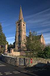 | |||
| Blythill (2 Houses - Miss Newbigging) Old Bridge Lane | 56°37′28″N 3°13′55″W | Category C(S) | 21052 | | |||
| 16 Commercial Street | 56°37′24″N 3°13′49″W | Category C(S) | 21056 | | |||
| Alyth School, St. Andrew Street (Original School Only) | 56°37′14″N 3°14′00″W | Category B | 21060 | | |||
| 5 High Street | 56°37′30″N 3°13′59″W | Category B | 21044 | | |||
| Ivybank And 7 Hill Street | 56°37′32″N 3°13′53″W | Category C(S) | 21047 | | |||
| Leadenhall, Chapel Street | 56°37′29″N 3°13′58″W | Category B | 21048 | | |||
| Old Packbridge Over Alyth Burn | 56°37′27″N 3°13′55″W | Category B | 21050 | | |||
| Bridge House (Robertson) Old Bridge Lane | 56°37′27″N 3°13′55″W | Category B | 21051 | | |||
| Alyth (Barony) Church | 56°37′26″N 3°13′51″W | Category B | 21055 | | |||
| Bridge Of Dillavaird Over River Isla | 56°38′30″N 3°09′01″W | Category B | 4365 | | |||
| Bamff House South Lodge | 56°38′29″N 3°16′12″W | Category C(S) | 4367 | | |||
| Craigellie House | 56°37′36″N 3°15′32″W | Category B | 4376 | | |||
| Balhary Walled Garden | 56°36′19″N 3°12′08″W | Category B | 4382 | | |||
| Balhary Sundial | 56°36′17″N 3°12′06″W | Category B | 4383 | | |||
| Jordanstone House | 56°36′45″N 3°11′10″W | Category B | 4386 | | |||
| Milne, The Cross | 56°37′30″N 3°13′56″W | Category B | 21042 | | |||
| Inverquiech Castle | 56°37′59″N 3°10′43″W | Category B | 4363 | | |||
| Burial Enclosure Of Admiral Knight, Jordanstone | 56°36′45″N 3°11′08″W | Category B | 4390 | | |||
| Balendoch Doocot | 56°36′57″N 3°09′48″W | Category C(S) | 4391 | |
Key
The scheme for classifying buildings in Scotland is:
- Category A: "buildings of national or international importance, either architectural or historic; or fine, little-altered examples of some particular period, style or building type."[1]
- Category B: "buildings of regional or more than local importance; or major examples of some particular period, style or building type, which may have been altered."[1]
- Category C: "buildings of local importance; lesser examples of any period, style, or building type, as originally constructed or moderately altered; and simple traditional buildings which group well with other listed buildings."[1]
In March 2016 there were 47,288 listed buildings in Scotland. Of these, 8 per cent were Category A, and 50 per cent were Category B, with the rest listed at Category C.[2]
Notes
- Sometimes known as OSGB36, the grid reference (where provided) is based on the British national grid reference system used by the Ordnance Survey.
• "Guide to National Grid". Ordnance Survey. Retrieved 2007-12-12.
• "Get-a-map". Ordnance Survey. Retrieved 2007-12-17. - Historic Environment Scotland assign a unique alphanumeric identifier to each designated site in Scotland, for listed buildings this always begins with "LB", for example "LB12345".
References
- All entries, addresses and coordinates are based on data from Historic Scotland. This data falls under the Open Government Licence
- "What is Listing?". Historic Environment Scotland. Retrieved 29 May 2018.
- Scotland's Historic Environment Audit 2016 (PDF). Historic Environment Scotland and the Built Environment Forum Scotland. pp. 15–16. Retrieved 29 May 2018.
This article is issued from Wikipedia. The text is licensed under Creative Commons - Attribution - Sharealike. Additional terms may apply for the media files.