List of listed buildings in Dron, Perth and Kinross
List
| Name | Location | Date Listed | Grid Ref. [note 1] | Geo-coordinates | Notes | LB Number [note 2] | Image |
|---|---|---|---|---|---|---|---|
| Balmanno Castle Including Garden House Outbuilding And Gatehouse | 56°19′29″N 3°23′11″W | Category A | 5422 |  | |||
| Kilnockie Railway Viaduct | 56°19′10″N 3°22′08″W | Category B | 5433 | | |||
| Glenfarg Railway Viaduct Over River Farg | 56°18′11″N 3°22′01″W | Category B | 5434 | | |||
| Glenfarg House, Stable Block | 56°19′20″N 3°21′19″W | Category B | 6383 | | |||
| Glenearn House | 56°19′58″N 3°26′30″W | Category B | 5425 | | |||
| Dron Parish Church | 56°19′40″N 3°23′26″W | Category B | 5448 | | |||
| Balmanno Castle Steading | 56°19′28″N 3°23′04″W | Category B | 5423 | | |||
| Glenearn Lodge | 56°20′05″N 3°26′01″W | Category B | 5424 | | |||
| Cottage (Empty In 1967) The Bein Inn | 56°18′10″N 3°21′30″W | Category B | 77 | | |||
| East Dron House | 56°19′36″N 3°23′32″W | Category C(S) | 5421 | | |||
| Ecclesmagirdle, Loupin' On Stane | 56°19′53″N 3°26′42″W | Category B | 5429 | | |||
| Dron Churchyard | 56°19′39″N 3°23′26″W | Category B | 5419 | | |||
| Ecclesmagirdle, Doocot | 56°19′53″N 3°26′41″W | Category A | 5430 | | |||
| Ecclesmagirdle, Chapel | 56°19′52″N 3°26′42″W | Category B | 5431 | | |||
| Glenfarg House, Gatelodge | 56°19′24″N 3°21′17″W | Category B | 6384 | | |||
| Ecclesmagirdle (Or Ecclesiamagirdle) House | 56°19′53″N 3°26′42″W | Category A | 5427 | | |||
| Manse Of Dron (Now Mrs. Mclean) | 56°19′40″N 3°23′29″W | Category C(S) | 5420 | | |||
| Glenearn House Sundial | 56°20′01″N 3°26′35″W | Category B | 5426 | | |||
| Ecclesmagirdle, Gateway | 56°19′53″N 3°26′42″W | Category B | 5428 | | |||
| Steading, The Bein Inn | 56°18′10″N 3°21′30″W | Category C(S) | 5435 | | |||
| Pottiehill Farmhouse | 56°18′35″N 3°21′38″W | Category B | 5436 | | |||
| Glenearn Farmhouse | 56°19′48″N 3°26′38″W | Category C(S) | 5432 | | |||
| Glenfarg House | 56°19′20″N 3°21′23″W | Category B | 5437 | 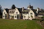 |
Key
The scheme for classifying buildings in Scotland is:
- Category A: "buildings of national or international importance, either architectural or historic; or fine, little-altered examples of some particular period, style or building type."[1]
- Category B: "buildings of regional or more than local importance; or major examples of some particular period, style or building type, which may have been altered."[1]
- Category C: "buildings of local importance; lesser examples of any period, style, or building type, as originally constructed or moderately altered; and simple traditional buildings which group well with other listed buildings."[1]
In March 2016 there were 47,288 listed buildings in Scotland. Of these, 8 per cent were Category A, and 50 per cent were Category B, with the rest listed at Category C.[2]
Notes
- Sometimes known as OSGB36, the grid reference (where provided) is based on the British national grid reference system used by the Ordnance Survey.
• "Guide to National Grid". Ordnance Survey. Retrieved 2007-12-12.
• "Get-a-map". Ordnance Survey. Retrieved 2007-12-17. - Historic Environment Scotland assign a unique alphanumeric identifier to each designated site in Scotland, for listed buildings this always begins with "LB", for example "LB12345".
References
- All entries, addresses and coordinates are based on data from Historic Scotland. This data falls under the Open Government Licence
- "What is Listing?". Historic Environment Scotland. Retrieved 29 May 2018.
- Scotland's Historic Environment Audit 2016 (PDF). Historic Environment Scotland and the Built Environment Forum Scotland. pp. 15–16. Retrieved 29 May 2018.
This article is issued from Wikipedia. The text is licensed under Creative Commons - Attribution - Sharealike. Additional terms may apply for the media files.