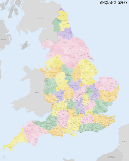
List of hundreds of England and Wales
Most of the counties of England were divided into hundreds from the late Saxon period and these were, with a few exceptions, effectively abandoned as administrative divisions in the 19th century. in some areas, equivalent districts were known as "wapentakes".[1]
In Wales a similar Celtic system of division called cantrefi (a hundred farmsteads) had existed for centuries and was of particular importance in the administration of the Welsh law. Following the Laws in Wales Acts 1535 and 1542, Wales was divided into hundreds to be consistent with England.
Bedfordshire

- Barford
- Biggleswade
- Clifton
- Flitt
- Manshead
- Redbornestoke
- Stodden
- Willey
- Wixamtree
Berkshire

The County of Berkshire comprised 20 Hundreds and 193 parishes and parts of four others.[2] From The National Gazetteer of Britain and Ireland (1868), Victoria County History Berkshire Vol 3 (1923)[3] & Vol 4 (1924)[4]
Buckinghamshire

Until at least the time of the Domesday Survey in 1086 there were 18 hundreds in Buckinghamshire.[7] It has been suggested however that neighbouring hundreds had already become more closely associated in the 11th century so that by the end of the 14th century the original or ancient hundreds had been consolidated into 8 larger hundreds.[8]
- Ashendon Hundred
- Aylesbury Hundred – consolidated from the eleventh century Aylesbury, Risborough and Stone hundreds
- Buckingham Hundred
- Cottesloe Hundred
- Newport Hundred
Chiltern Hundreds
Cambridgeshire
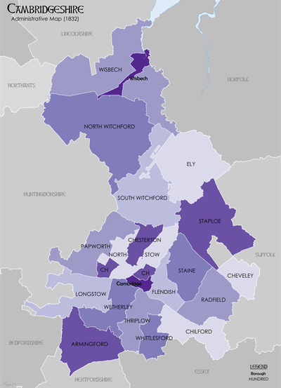
Cambridgeshire was divided into 17 hundreds, plus the borough of Cambridge. Each hundred had a separate council that met each month to rule on local judicial and taxation matters. In 1929 the hundreds contained the following parishes.[9][10]
Cheshire
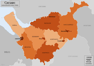
From Harris, B. E., and Thacker, A. T. (1987). The Victoria History of the County of Chester. (Volume 1: Physique, Prehistory, Roman, Anglo-Saxon, and Domesday). Oxford: Oxford University Press. ISBN 0-19-722761-9.
- Broxton
- Bucklow
- Eddisbury
- Macclesfield
- Nantwich
- Northwich
- Wirral
Cornwall
In Cornwall, the name calqued cantrev

- Penwith (Penwyth)
- Kerrier (Keryer)
- Pydar (Pedera)
- Powder (Pow Ereder)
- Trigg (Trigor)
- Lesnewth (Lysnowyth)
- Stratton (Stradneth)
- West (Fawy)
- East (Ryslegh)
For some purposes, the Isles of Scilly were counted as a tenth hundred.
Cumberland
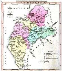
Cumberland was divided into wards, analogous to hundreds. From the National Gazetteer of Britain and Ireland
- Allerdale-above-Derwent
- Allerdale-below-Derwent
- Cumberland
- Eskdale
- Leath
Derbyshire
The civil divisions of Derbyshire were anciently called wapentakes. In the Domesday Survey of 1086 are mentioned the wapentakes of Scarvedale, Hamestan, Morlestan, Walecross, and Apultre, and a district called Peche-fers.[12] Divided into hundreds by 1273. From GENUKI (based on the 1868 Gazette):
- High Peak—Hamestan wapentake and perhaps Peche-fers district in 1086; Peck wapentake by 1273.
- Wirksworth—Called a wapentake as late as 1817.
- Scarsdale
- Morleston and Litchurch—Called in the Domesday Survey of 1086, Morlestan or Morleystone wapentake and Littlechurch wapentake,[13] and in the Hundred-Roll of 1273, Littlechirch; by 1300 combined as the hundred of Morleston and Litchurch.[14]
- Appletree
- Repton and Gresley—In 1274 formed the separate wapentakes of Repindon and Greselegh (owned by the King and the heirs of the Earl of Chester respectively); in 1086 the large Walecross wapentake.
Devon
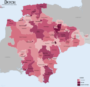
In 1850 there were thirty-two hundreds in Devon according to White's History, Gazetteer, and Directory of Devonshire[15]
Dorset

|
|
County Durham
County Durham was divided into wards, analogous to hundreds. From an 1840 map of County Durham .
- Chester-le-Street
- Sadberge
- Easington
- Stockton
Essex

- Barstable (sometimes spelled Barnstable)
- Becontree
- Chafford
- Chelmsford
- Clavering
- Dengie, known at the time of Domesday as Witbrictesherna (Wibrihtesherne) Hundred
- Dunmow
- Freshwell
- Harlow
- Liberty of Havering, also sometimes known as Romford Hundred
- Hinckford
- Lexden
- Ongar
- Rochford
- Tendring
- Thurstable
- Uttlesford
- Waltham
- Winstree
- Witham
According to essex1841.com the 1841 census also recorded Harwich hundred, which the Victoria County History places within Tendring.
Gloucestershire
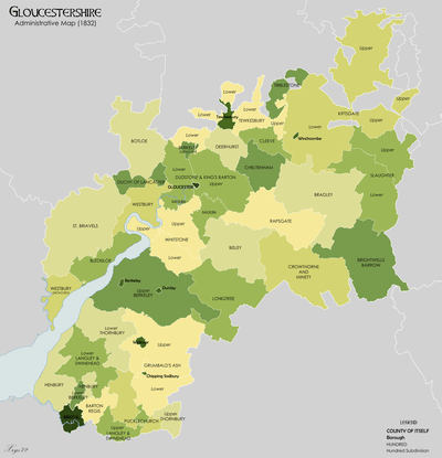
The thirty-nine hundreds mentioned in the Domesday Survey and the thirty-one hundreds of the Hundred Rolls of 1274 differ very widely in name and extent both from each other and from the twenty-eight hundreds of the present day. From the National Gazetteer of Britain and Ireland
- Barton Regis
- Berkeley
- Bishop's Cleeve
- Bisley
- Bledisloe
- Botloe
- Bradley
- Brightwell's Barrow
- Cheltenham
- Cleeve
- Crowthorne-with-Minety
- Deerhurst
- Dudstone (upper, middle and lower divisions)
- Grumbalds Ash
- Henbury
- Kiftsgate (upper and lower divisions)
- Langley and Swinehead
- Longtree
- Lower Slaughter
- Lower Tewkesbury
- Lower Thornbury
- Pucklechurch
- Rapsgate
- St Briavels
- Tibaldstone
- Upper Slaughter
- Upper Tewkesbury[17]
- Upper Thornbury[18]
- Westbury
- Westminster
- Whitstone (upper and lower divisions) – absorbed the Blacklow hundred by 1220.
The Duchy of Lancaster (Gloucestershire) liberty was sometimes counted as a hundred.
Hampshire

|
Herefordshire
The hundreds mentioned in the Domesday Survey and the hundreds of the Hundred Rolls of 1274 differ very widely in name and extent both from each other and from the ten hundreds of the present day. Not included in the hundreds of Herefordshire at the time of Domesday, the sparsely populated Welch area of Archenfield included Ashe Ingen, Baysham and Kings Caple.[19]
From Domesday (1086):
- Bromsash
- Castlery[20]
- Cutestornes[21]
- Dinedor[22]
- Ewias[23]
- Greitrewes[24]
- Hazeltree – Hezetre[25]
- Plegelgete[26]
- Radlow[27]
- Sellack
- Stradel[28]
- Tornelaus[29]
From The National Gazetteer of Britain and Ireland (1868)
- Broxash
- Ewyas-Lacy
- Greytree
- Grimsworth
- Radlow
- Stretford
- Webtree[30]
- Wigmore
- Wolphy
- Wormelow (upper and lower divisions)
Hertfordshire

(Danais & Tring added as per History of Hertfordshire)[31]
- Braughing
- Broadwater
- Cashio (Previously known as St Albans Hundred)
- Dacorum
- Danais (merged with Tring to form Dacorum)
- Edwintree
- Hertford
- Hitchin
- Odsey
- Tring (merged with Danais to form Dacorum)
Huntingdonshire
- Hurstingstone
- Leightonstone
- Norman Cross
- Toseland
Kent

From Kent Genealogy . Kent was traditionally divided into East and West Kent, and into lathes and hundreds.
East Kent
Lathes: St. Augustine, Scraye, Shepway
|
|
|
plus Romney Marsh Liberty
West Kent
|
|
|
|
|
|
|
|
plus the Lowey of Tonbridge
Lathe of Scraye (part)
|
|
|
Lancashire
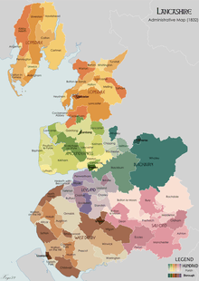
- Amounderness
- Blackburn
- Leyland
- Lonsdale
- Salford
- West Derby
Leicestershire
Leicestershire was originally divided into four wapentakes, but these were usually later described as hundreds. From the 1911 Encyclopædia Britannica[32] after 1346 the six hundreds were:
- East Goscote
- Framland
- Gartree
- Guthlaxton
- Sparkenhoe
- West Goscote
In the Domesday Book, West Goscote and East Goscote made up just Goscote and Sparkenhoe did not yet exist. The division which brought East and West Goscote and Sparkenhoe into existence was made in 1346.
Lincolnshire

Lincolnshire was divided into three Parts, each of which was divided into wapentakes, analogous to hundreds.
From map on Lincolnshire County Council website:[33]
- Elloe[34]
- Kirton
- Skirbeck
- Parts of Kesteven
- Aswardhurn
- Aveland
- Boothby Graffoe (Higher and Lower divisions)
- Beltisloe
- Flaxwell
- Langoe (First and Second divisions)
- Loveden
- Ness
- Winnibriggs and Threo (wapentake)
- Parts of Lindsey
- North Riding of Lindsey
- Bradley-Haverstoe
- Ludborough
- Walshcroft (North and South divisions)
- Yarborough
- South Riding of Lindsey
- Calceworth (Marsh and Wold divisions)
- Candleshoe (Marsh and Wold divisions)
- Gartree[35] (North and South divisions)
- Hill
- Louth-Eske (Marsh and Wold divisions)
- Wraggoe (East and West divisions)
- West Riding of Lindsey
- Aslacoe (East and West divisions)
- Corringham
- Epworth[36] (compare Isle of Axholme)
- Manley (East, North, and West divisions)
- Lawress
- Well
Middlesex
- Edmonton
- Elthorne
- Gore
- Isleworth (recorded in 1086 as Hounslow)[37]
- Ossulstone
- Spelthorne
Norfolk
|
|
|
|
|
|
|
Northamptonshire
In 1086, there were 29 hundreds in the county. By the time of the 'Nomina Villarum' a survey carried out in the first half of the 12th Century, the Stoke Hundred had been absorbed into the Corby Hundred.[39] From the Northamptonshire Family History Society[40] the hundreds in the 1800s are:
|
|
|
|
|
|
The liberty and Soke of Peterborough was sometimes called Nassaburgh hundred.
Northumberland
Following the Harrying of the North and subsequent incursions from Scotland, the high sheriff of Northumberland was granted extraordinary powers. The county was subdivided into baronies, which were arranged in six wards and subdivided into constabularies.[42] The wards were analogous to hundreds. From the National Gazetteer of Britain and Ireland (1868)
Nottinghamshire
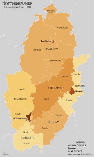
Nottinghamshire was divided into wapentakes, analogous to hundreds. From the Thoroton Society of Nottinghamshire
- Bassetlaw (North Clay, South Clay and Hatfield divisions)
- Bingham (North and South divisions)
- Broxtowe (North and South divisions)
- Newark (North and South divisions)
- Rushcliffe (North and South divisions)
- Thurgarton (North and South divisions)
Oxfordshire
From[45]
- Bampton[46][47]
- Banbury
- Binfield[48]
- Bloxham[49]
- Bullingdon
- Chadlington
- Dorchester
- Ewelme (Known as Benson hundred in 1070)[50]
- Kirtlington[51] - A hundred at the time of Domesday, it was combined to form the major portion of Ploughley hundred by 1169.
- Langtree
- Lewknor[52]
- Pyrton - Pirton is a later Latinised spelling.[53]
- Ploughley[54] - Name first mentioned in the form Pokedelawa hundred in the Pipe Roll of 1169.
- Thame
- Wootton - Includes the three hundreds dependent on the royal manor of Wootton in 1086[55] and sometimes called the "three hundreds of Wootton"[56] in the later 12th century: Shipton hundred,[57] (unknown name) hundred and pre-1086 Wootten hundred.[58] The hundred was later divided into two administrative regions:
- Wootton (Northern part) - 19 parishes including Barford St. Michael, Deddington, Glympton, Heythrop, Rousham, Sandford St. Martin, South Newington, Stonesfield, Tackley, Wootton, the Astons (North Aston and Steeple Aston), the Bartons (Steeple Barton and Westcott Barton), the Wortons (formed in 1932 by combining Nether Worton and Over Worton parishes), and the three Tews (Great Tew, Little Tew and Duns Tew).
- Wootton (Southern part) - 15 parishes and several extraparochial places[59]
- Within Woolton hundred yet separately administered were the areas of Oxford City & University,[60] Oxford City and Oxford Liberty.[61]
Rutland

- Alstoe
- East
- Martinsley
- Oakham
- Wrandike
Shropshire

From GENUKI[62]
|
|
† — including the Shropshire exclave of Halesowen ‡ The liberties of the borough of Shrewsbury and priory/borough of Wenlock were extensive and are usually considered as hundreds (Wenlock was sometimes described as the "franchise of Wenlock").[64]
Somerset

From the National Gazetteer of Britain and Ireland
|
|
|
Suffolk
|
|
|
|
|
|
|
Surrey
.jpg)
There are thirteen hundreds and one half hundred:
|
|
|
|
Sussex
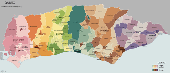
Sussex was divided into rapes, and then hundreds.
Arundel Rape
The Arundel Rape covered nearly all of what is now West Sussex until about 1250, when it was split into two rapes the Arundel Rape and the Chichester Rape.[67] In 1834 it contained five hundreds sub-divided into fifty six parishes.[68]
- Avisford
- Bury
- Poling
- Rotherbridge
- West Easwrith
Bramber Rape
The Bramber Rape lies between the Rape of Arundel in the west and Lewes in the east. In 1834 it contained 40 parishes[69] in the following hundreds:
- Brightford
- Burbeach
- West Grinstead (Grensted in the Domesday Survey)
- Poling (once known as Rieberge)
- Singlecross
- Steyning
- Tarring (a peculier of the Archbishop of Canterbury)
- Tipnoak
as well as 3 half hundreds
- East Easwrith
- Fishersgate
- Wyndham
Chichester Rape
The combined Chichester and Arundel Rape covered nearly all of what is now West Sussex until about 1250, when it was split into two rapes the Arundel Rape and the Chichester Rape.[67] In 1834 it contained seven hundreds and seventy-four parishes.[70]
- Aldwick
- Bosham
- Box and Stockbridge
- Dumpford
- Easebourne
- Manhood
- Westbourne and Singleton
Hastings Rape
Medieval sources talk of a group of people who were separate to that of the South Saxons they were known as the Haestingas. The area of Sussex they occupied became the Rape of Hastings.[71] The Rape of Hastings was on the easternmost part of Sussex, with the county of Kent to its east and the Rape of Pevensey to its west. In 1833 it had 13 hundreds giving a total of about 154,060 acres.[72]
Lewes Rape
The Rape of Lewes is bounded by the Rape of Bramber on its west and the Rape of Pevensey on its east. Although it had the same amount of hundreds in 1833 as in the Domesday survey, there had been some cases of manors and parishes been taken from one and added to another hundred, and in other cases the hundreds had been divided and lost.[73]
- Barcombe
- Buttinghill
- Dean
- Fishergate
- Holmestrow
- Poynings
- Preston
- Street
- Swanborough
- Whalesbourne
- Younsmere (also Falmer)
Pevensey Rape
The Pevensey Rape lies between the Rapes of Lewes and Hastings. In 1833 it contained 19 hundreds and 52 parishes[74]
- Alciston
- Bishopstone
- Danehill Horsted
- Dill
- Eastbourne
- East Grinstead (Grinsted in the Domesday survey)
- Flexborough
- Hartfield
- Lindfield Burley-Arches (also Burarches)
- Lowey or Liberty of Pevensey - Part of Port of Hastings, so having the immunities and privileges of the Cinque Ports.
- Loxfield Camden
- Loxfield Dorset
- Longbridge
- Ringmer
- Rotherfield
- Rushmonden
- Shiplake
- Totnore
- Willingdon
Warwickshire

Warwickshire was divided into four hundreds, with each hundred consisting of a number of divisions.
- Barlinchway (also Barlichway)
- Alcester
- Henley
- Snitterfield
- Stratford
- Hemlingford, formerly named Coleshill
- Atherstone
- Birmingham
- Solihull
- Tamworth
- Kington (also Kineton)
- Brailes
- Burton Dassett
- Kington
- Warwick
- Knightlow
- Kenilworth
- Kirby
- Rugby
- Southam
Westmorland
Westmorland was divided into four wards, analogous to hundreds. Pairs of wards made up the two Baronies. From Magna Britannica et Hibernia (1736)
Wiltshire
There were 40 hundreds in Wiltshire at the time of the Domesday Survey. Hundreds in 1835 were:
|
|
|
|
|
|
Worcestershire
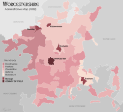
The ancient hundreds in 1086 at the time of the Domesday survey were:[75] Ash, Came, Celfledetorn, Clent, Cresslow, Cutestornes, Doddingtree, Dudstone, Fernecumbe, Fishborough, Greston, Ossulstone, Oswaldslow, Pershore, Plegelgete, Seisdon, Tewkesbury, Tibblestone, Wolfhay. Some of the parishes within these hundreds, such as Feckenham in Ash Hundred, or Gloucester in Dudstone Hundred, may have partially been in other counties or were transferred between counties in the intervening years.
Over the centuries, some of the hundreds were amalgamated and appear in many useful statistical records. The hundreds that continued their courts until disuse include:
Yorkshire
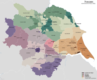
Yorkshire has three Ridings,[80] East, North and West. Each of these was divided into wapentakes, analogous to hundreds.
The Ainsty wapentake, first associated with the West Riding, became associated in the fifteenth century with the City of York, outside the Riding system.
The hundreds of Amounderness and Lonsdale in Lancashire plus part of Westmorland were considered as part of Yorkshire in the Domesday Book.
East Riding of Yorkshire
- Buckrose
- Dickering Wapentake
- Harthill Wapentake (Bainton Beacon, Holme Beacon, Hunsley Beacon and Wilton Beacon divisions)
- Holderness Wapentake (North, Middle and South divisions)
- Howdenshire
- Ouse and Derwent
The other division of the riding was Hullshire.
North Riding of Yorkshire
- Allerton
- Birdforth
- Bulmer
- Gilling East
- Gilling West
- Hallikeld
- Hang East
- Hang West
- Langbaurgh (West and East divisions)
- Pickering Lythe – Formed from the Domesday wapentake of Dic, and additionally by 1284–85 the parish of Sinnington and by (circa 15th-16th century) the parish of Kirkby Misperton, both from the Domesday wapentake of Maneshou.[81]
- Ryedale – First mentioned by name in 1165–66, probably when its court was relocated there. Formed from the Domesday wapentake of Maneshou minus Sinnington and Kirkby Misperton parishes, plus the additional parish of Lastingham from the Domesday wapentake of Dic.[81] In the 19th century, Ryedale contained the parishes of Ampleforth; Appleton-Le-Street; Barton-Le-Street; Great Edston; Gilling; Helmsley; Hovingham; Kirkby Moorside; Kirkdale; Lastingham; New Malton, including the parishes of St. Leonard and St. Michael; Old Malton; Normanby; Nunnington; Oswaldkirk; Salton; Scawton; Slingsby; Stonegrave.[81]
- Whitby Strand
West Riding of Yorkshire
- Agbrigg and Morley (Agbrigg and Morley divisions)
- Ainsty wapentake (___ and ___ divisions) (became a district named Ainsty of York in the 15th century)
- Barkston Ash Wapentake
- Claro Wapentake (Upper and Lower divisions) (Burghshire wapentake was renamed in the 12th century)
- Ewcross
- Osgoldcross Wapentake
- Skyrack (Upper and Lower divisions)
- Staincliffe Wapentake (East and West divisions)
- Staincross Wapentake
- Strafforth and Tickhill (Upper and Lower divisions)
The Hundreds of Wales
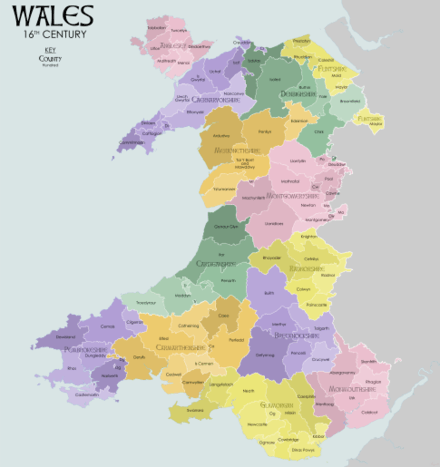
Wales was divided into hundreds following the Laws in Wales Acts 1535 and 1542. This resulted in the creation of five new counties (Monmouthshire, Brecknockshire, Radnorshire, Montgomeryshire and Denbighshire) from the Marches of Wales. Combined with the transformation of the Lordships of Pembroke and Glamorgan into new counties, with the existing counties of Cardiganshire, Caernarfonshire and Flintshire (created by the Statute of Rhuddlan) this gave Wales thirteen counties.
Anglesey
Anglesey was divided into six hundreds:[82] [83]
- Dindaethwy
- Llifon
- Malltraeth
- Menai
- Talybolion
- Twrcelyn
Brecknockshire
Brecknockshire was divided into six hundreds. [84] [85]
Caernarvonshire
Caernarvonshire was divided into ten hundreds: [86] [87]
Cardiganshire
Cardiganshire was divided into five hundreds.[88] [89]
- Genaur Glyn
- Ilar
- Moyddyn
- Penarth
- Troedyraur
Carmarthenshire
Carmarthenshire was divided into eight hundreds.[90] [91]
- Carnwyllion
- Catheiniog
- Caeo
- Cedweli
- Derllys
- Elfed
- Is Cennen
- Perfedd
Denbighshire
Denbighshire was divided into six hundreds:[92] [93]
Flintshire
Flintshire was divided into five hundreds: [94] [95]
Glamorgan
Glamorgan was divided into ten hundreds: [96] [97]
- Caerphilly
- Cowbridge
- Dinas Powys
- Kibbor
- Llangyfelach
- Miskin
- Neath
- Newcastle
- Ogmore
- Swansea
Merionethshire
Merionethshire was divided into five hundreds: [98] [99]
Monmouthshire
Monmouthshire was divided into five hundreds: [100] [101]
- Abergavenny
- Caldicot
- Rhaglan
- Skenfrith
- Usk
- Wentloog
Montgomeryshire
Montgomeryshire was divided into eight hundreds: [102] [103]
- Cawrse
- Deuddwr
- Llanfyllin
- Machynlleth
- Mathrafal
- Montgomery
- Newtown
- Pool
Pembrokeshire
Pembrokeshire was divided into seven hundreds: [104] [105]
- Castlemartin
- Cemais
- Cilgerran
- Dewisland
- Dungleddy
- Narberth
- Rhos
Radnorshire
Radnorshire was divided into six hundreds: [106] [107]
- Cefnllys
- Colwyn
- Knighton
- Painscastle
- Radnor
- Rhayader
References
- Webb, Sidney; Webb, Beatrice (1906). English Local Government from the Revolution to the Municipal Corporations Act: the parish and the county. London: Longmans Green and Company. pp. 284–285.
- "GENUKI".
- "Victoria County History Berkshire Vol 3".
- "Victoria County History Berkshire Vol 4".
- http://www.british-history.ac.uk/vch/berks/vol4/p486 British History Online: The Hundred of Faringdon
- http://domesdaymap.co.uk/hundred/ripplesmere/ Open Domesday: Ripplesmere hd.
- Open Domesday Online: Buckinghamshire
- Genuki - History of Buckinghaham Hundreds Archived 23 August 2009 at the Wayback Machine Retrieved, 21 May 2009
- "Cambridgeshire Hundreds". rootsweb.
- Kelly (1929). Directory of Cambridgeshire, Norfolk & Suffolk.
- "'South Witchford Hundred: Stretham and Thetford', A History of the County of Cambridge and the Isle of Ely: Volume 4: City of Ely; Ely, N. and S. Witchford and Wisbech Hundreds (2002), pp. 151-159". British History Online.
- https://books.google.com/books?id=qUBaAAAAcAAJ&pg=PR11&dq=Morleston+Wapentake&hl=en&sa=X&ei=lAzrVPPuIcKiNrnDg6AP&ved=0CDoQ6AEwBQ#v=onepage&q=Morleston%20Wapentake&f=false Derbyshire 5, page xi.
- http://domesdaymap.co.uk/search/?geo=Litchurch Domesday Map Online: Litchurch
- Craven, Maxwell: Derby Street by Street (Breedon Books, Derby, 2005) ISBN 1-85983-426-4
- "The Hundreds of Devon". GENUKI. Retrieved 20 June 2011.
- "Alvredesberge Hundred was broken up after 1086 and contributed Cranborne, Boveridge, Edmondsham and Pentridge to the later Cranborne Hundred; Brockington to Knowlton Hundred and Wimborne St Giles (see Book of Fees, p. 92; and 10,3 Wimborne note) to the later Wimborne Hundred", quoted from:
- British History Online: Tewkesbury hundred (Upper division)
- "Archived copy". Archived from the original on 17 December 2014. Retrieved 28 September 2014.CS1 maint: archived copy as title (link)
- History: the Hundreds.
- Open Domesday Online: Castlery
- Open Domesday Online: Cutestornes Hundred
- Open Domesday Online: Dinedor Hundred
- Open Domesday Online: Ewias Hundred
- Open Domesday Online: Greytree Hundred
- Open Domesday Online: Hezetre Hundred
- Open Domesday Online: Plegelgete Hundred
- Open Domesday Online: Radlow Hundred
- Open Domesday Online: Stradel Hundred
- Open Domesday Online: Tornelaus Hundred
- Vision of Britain: Boundary Map of Webtree Hundred
- http://opendomesday.org/county/hertfordshire/ Open Domesday Map: Hertfordshire
- Chisholm, Hugh, ed. (1911). . Encyclopædia Britannica. 16 (11th ed.). Cambridge University Press. p. 394.
- http://www.lincolnshire.gov.uk/section.asp?docId=28101&catId=2630
- "Archived copy". Archived from the original on 8 February 2015. Retrieved 8 February 2015.CS1 maint: archived copy as title (link) Open Domesday Map: Elloe Wapentake
- http://domesdaymap.co.uk/hundred/gartree/ Open Domesday: Gartree (Lincolnshire wapentake)
- "Archived copy". Archived from the original on 14 October 2014. Retrieved 27 November 2014.CS1 maint: archived copy as title (link)
- "The hundred of Isleworth", A History of the County of Middlesex: Volume 3, (1962), Date accessed: 6 January 2008.
- William White (1845). History, gazetteer, and directory of Norfolk. Published by the author. p. 14.
- http://www.cottinghamhistory.co.uk/Hundred%20map.htm
- "About the County". Archived from the original on 16 January 2006. Retrieved 28 November 2005.
- http://domesdaymap.co.uk/hundred/guilsborough/%5B%5D Domesday: Guilsborough hundred
- https://books.google.com/books?id=-w5CAAAAcAAJ&pg=PA320&dq=Society+for+the+Diffusion+of+Knowledge+Northumberland+320&hl=en&sa=X&ei=GiOjVcW3AYm7-AGuhajwBA&ved=0CDMQ6AEwBA#v=onepage&q=Society%20for%20the%20Diffusion%20of%20Knowledge%20Northumberland%20320&f=false "The Penny Cyclopædia of the Society for the Diffusion of Useful Knowledge", Vol. 15-16, page 320.
- http://www.visionofbritain.org.uk/place/20065 Vision of Britain: Castle Ward Map
- https://books.google.com/books?id=UUJiAAAAcAAJ&pg=PA19&lpg=PA19&dq=Glendale+ward+and+constableries&source=bl&ots=rOJbY8ExIT&sig=zrg7UJQTlXQm59sByGhis4Qdkrc&hl=en&sa=X&ei=ryejVcWzDIjk-AH3lYNg&ved=0CB8Q6AEwAA#v=onepage&q=Glendale%20ward%20and%20constableries&f=false A list of the wards, divisions, parishes, and constableries, in the County of Northumberland: Glendale Ward
- Vision of Britain website Archived 12 April 2012 at the Wayback Machine
- http://domesdaymap.co.uk/hundred/bampton/ Open Domesday: Bampton hundred
- http://www.british-history.ac.uk/vch/oxon/vol13/pp1-5 British History Online: Bampton hundred
- http://domesdaymap.co.uk/hundred/binfield/ Open Domesday: Binfield hundred
- http://domesdaymap.co.uk/hundred/bloxham/ Archived 14 December 2014 at the Wayback Machine Open Domesday: Bloxham hundred
- http://domesdaymap.co.uk/hundred/benson/ Archived 14 December 2014 at the Wayback Machine Open Domesday: Benson hundred
- http://domesdaymap.co.uk/hundred/kirtlington/ Archived 14 December 2014 at the Wayback Machine Open Domesday: Kirtlington hundred
- http://domesdaymap.co.uk/hundred/lewknor/ Archived 14 December 2014 at the Wayback Machine Open Domesday: Lewknor hundred
- http://domesdaymap.co.uk/hundred/pyrton/ Archived 14 December 2014 at the Wayback Machine Open Domesday: Pyrton hundred
- http://www.british-history.ac.uk/vch/oxon/vol6/pp1-6 British History Online: Ploughley hundred
- http://www.british-history.ac.uk/vch/oxon/vol11/pp1-5 British History Online: Wootten Hundred
- http://www.british-history.ac.uk/vch/oxon/vol11/xii British History Online: Wootten hundred
- http://domesdaymap.co.uk/hundred/shipton/ Archived 14 December 2014 at the Wayback Machine Open Domesday: Shipton hundred
- http://domesdaymap.co.uk/hundred/wootton/ Archived 28 September 2014 at the Wayback Machine Open Domesday: Wootten hundred
- http://www.british-history.ac.uk/vch/oxon/vol12/pp1-2 British History Online: Wootten hundred (Southern part)
- http://www.british-history.ac.uk/vch/oxon/vol4/pp1-2 BHO: Oxford City Introduction
- http://www.british-history.ac.uk/topographical-dict/england/pp503-525 Topographical Dictionary: Oxford
- GENUKI Shropshire hundreds
- British History Online: Bradford Hundred
- British History Online The Liberty and Borough of Wenlock
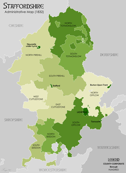
- http://www.genuki.org.uk/big/eng/STS/Hundreds
- William White (1844). History, gazetteer, and directory of Suffolk. p. 15.
- "'The rape of Chichester: Introduction', A History of the County of Sussex: Volume 4 (1953) pp. 1 - 2". Retrieved 28 August 2010.
- Horsfield. History of Sussex. Volume II pp.105-184
- Horsfield. History of Sussex. Volume II pp.185-274
- Horsfield. History of Sussex. Volume II pp.1-104
- Martin Welch. Early Anglo Saxon Sussex in Peter Brandon's. The South Saxons. pp. 33-34
- Horsfield. History of Sussex. Volume II pp.425-592
- Horsfield. History of Sussex. Volume I pp.103-268.
- Horsfield. History of Sussex. Volume I pp.269-424
- http://opendomesday.org/county/worcestershire/ Open Domesday Map: Worcestershire
- http://opendomesday.org/search/?geo=halfshire Open Domesday Map: Halfshire hundred
- http://www.british-history.ac.uk/vch/worcs/vol3/pp1-4 British History: Halfshire hundred
- http://opendomesday.org/hundred/clent/ Open Domesday Map: Clent Hundred
- http://opendomesday.org/hundred/cresslow/ Open Domesday Map: Cresslow Hundred
- Room, Adrian (1986). A Dictionary of True Etymologies. London: Routledge. pp. 148–149. ISBN 0-415-03060-9. - Riding is taken from the Old Norse thrithjung meaning thirdings one third of an equally important area.
- British History Online: The wapentake of Ryedale
- "Anglesey Ancient County". Visionofbritain.org. 2018. Retrieved 28 May 2018.
- "Returns for County of Anglesey". Great Britain Abstract of the Population. 1821. p. 431. Retrieved 28 May 2018.
- "Brecknockshire Ancient County". Visionofbritain.org. 2018. Retrieved 28 May 2018.
- "Returns for County of Brecon". Great Britain Abstract of the Population. 1821. p. 435. Retrieved 28 May 2018.
- "Caernarvonshire Ancient County". Visionofbritain.org. 2018. Retrieved 28 May 2018.
- "Returns for County of Caernarvon". Great Britain Abstract of the Population. 1821. p. 453. Retrieved 28 May 2018.
- "Cardiganshire Ancient County". Visionofbritain.org. 2018. Retrieved 28 May 2018.
- "Returns for County of Cardigan". Great Britain Abstract of the Population. 1821. p. 440. Retrieved 28 May 2018.
- "Carmarthenhire Ancient County". Visionofbritain.org. 2018. Retrieved 28 May 2018.
- "Returns for County of Carmarthen". Great Britain Abstract of the Population. 1821. p. 445. Retrieved 28 May 2018.
- "Denbighshire Ancient County". Visionofbritain.org. 2018. Retrieved 28 May 2018.
- "Returns for County of Denbigh". Great Britain Abstract of the Population. 1821. p. 454. Retrieved 28 May 2018.
- "Flintshire Ancient County". Visionofbritain.org. 2018. Retrieved 28 May 2018.
- "Returns for County of Flint". Great Britain Abstract of the Population. 1821. p. 459. Retrieved 28 May 2018.
- "Glamorgan Ancient County". Visionofbritain.org. 2018. Retrieved 28 May 2018.
- "Returns for County of Glamorgan". Great Britain Abstract of the Population. 1821. p. 462. Retrieved 28 May 2018.
- "Merionethshire Ancient County". Visionofbritain.org. 2018. Retrieved 28 May 2018.
- "Returns for County of Merioneth". Great Britain Abstract of the Population. 1821. p. 469. Retrieved 28 May 2018.
- "Monmouthhshire Ancient County". Visionofbritain.org. 2018. Retrieved 28 May 2018.
- "Returns for County of Monmouth". Great Britain Abstract of the Population. 1821. p. 431. Retrieved 28 May 2018.
- "Montgomeryshire Ancient County". Visionofbritain.org. 2018. Retrieved 28 May 2018.
- "Returns for County of Montgomery". Great Britain Abstract of the Population. 1821. p. 472. Retrieved 28 May 2018.
- "Pembrokeshire Ancient County". Visionofbritain.org. 2018. Retrieved 28 May 2018.
- "Returns for County of Pembroke". Great Britain Abstract of the Population. 1821. p. 477. Retrieved 28 May 2018.
- "Radnorshire Ancient County". Visionofbritain.org. 2018. Retrieved 28 May 2018.
- "Returns for County of Radnor". Great Britain Abstract of the Population. 1821. p. 482. Retrieved 28 May 2018.
- Bibliography
- Brandon, Peter, ed. (1978). The South Saxons. Chichester: Phillimore. ISBN 0-85033-240-0.
- Notes on Wapentakes in Lincolnshire, from 'Introduction: Lost vills and other forgotten places', Final Concords of the County of Lincoln: 1244-1272 (1920), pp. L-LXV
- Horsfield, Thomas Walker (1834). The History, Antiquities and Topography of the County of Sussex. Bakewell: Country Books. ISBN 978-1-906789-16-9.