Hang West
Hang West was a Wapentake (Hundred) in the North Riding of Yorkshire. Its name derives from its meeting place of Hang Bank which was halfway between Hutton Hang and the village of Finghall. Hang is believed to derive from the Old English word Hangar which meant a wooded slope.[1] The place is mentioned in the Domesday Book as Hotun.[2] Hang West was divided up into 12 parishes.
| Hang West | |
|---|---|
| Wapentake | |
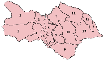 Wapentakes of North Yorkshire. Hang West is labelled as number 2. | |
| Subdivisions | |
| • Type | 12 parishes |
The Wapentake measured 25 miles (40 km) across (from west to east) and was 13 miles (21 km) from north to south. It was bordered on its eastern side by Hang East, the West Riding of Yorkshire on the southern side with Westmorland and the West Riding on the Western side.[3]
Settlements
The table below lists the settlements within the Hang West Wapentake. These are as listed in Bulmer's North Riding.[4]
Notes
- Only a small part of Grinton was in Hang West
- Now known as Patrick Brompton
- Was only partly in Hang West; most of the village was in Hang East
References
- Smith, A H (1928). The place-names of the North Riding of Yorkshire (1 ed.). Cambridge: Cambridge University Press. p. 229. OCLC 906264189.
- Horsfall-Turner, J (1908). Yorkshire place names : as recorded in the Yorkshire Domesday Book, 1086. Idel[sic]: Horsfall-Turner. p. 59. OCLC 181784558.
- White, William (1840). History, gazetteer, and directory, of the East and North Ridings of Yorkshire. Sheffield: William White. p. 601. OCLC 319907952.
- "Genuki: NRY HISTORY CONTENTS: , Yorkshire". www.genuki.org.uk. Retrieved 19 October 2017.
- "Vision of Britain | 1811 Census: Preliminary | Title and Contents Pages". www.visionofbritain.org.uk. Retrieved 19 October 2017.