Shinfield
Shinfield is a village and civil parish in the English county of Berkshire, just south of Reading. It contains 4,313 acres (17.45 km2) and is administered by the unitary authority of Wokingham District. Shinfield Park is the northern part of the parish, becoming physically separated when the M4 motorway was constructed in 1971.
| Shinfield | |
|---|---|
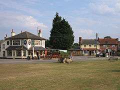 The Bell and Bottle and The Royal Oak facing onto the village green | |
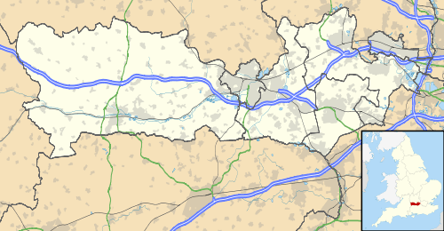 Shinfield Location within Berkshire | |
| Population | 8,136 (2001) 11,277 (2011 Census)[1] |
| OS grid reference | SU7368 |
| Civil parish |
|
| Unitary authority |
|
| Ceremonial county | |
| Region | |
| Country | England |
| Sovereign state | United Kingdom |
| Post town | Reading |
| Postcode district | RG2, RG7 |
| Dialling code | 0118 |
| Police | Thames Valley |
| Fire | Royal Berkshire |
| Ambulance | South Central |
| UK Parliament | |
Geography
The parish includes the roadside hamlets of Ryeish Green, Spencers Wood, Three Mile Cross, Shinfield Village and Grazeley and the southern suburb of Reading called Shinfield Rise. It is surrounded on its eastern and southern boundary by the River Loddon.
The M4 motorway runs west–east through the northern portion of the parish, near the former Berkshire County Council's Shire Hall, now the offices of John Wood Group;[2][3] the part to the north of the M4 corresponds closely with the part known as Shinfield Park. The main road through the village, running north–south, is the former A327, running between Reading and Aldershot, with the A327 now bypassing the village centre.
Shinfield Village is centred on the village green (School Green), surrounded by a pub, a shop, the village school and recreation grounds. Its residential housing has increased considerably during the first years of the 21st century.
The parish consists of a central ridge of high land sloping down to the Loddon on the east and the Kennet Valley on the west. The soil is mostly London Clay, with patchy spreads of valley and plateau gravel.
Government
As well as being part of the District of Wokingham, Shinfield is governed by a parish council consisting of fifteen parish councillors, assisted by two full-time administrative staff and several part-time caretaking and maintenance employees.
Shinfield has been part of the Hundred of Charlton since before the Norman Conquest. Hundreds effectively ceased to function after 1886. Between 1894 and 1974, it was in the Wokingham Rural District.
There are many manors and supposed manors in the parish: Shinfield, Hartley Dummer alias Arbor, Hartley Battle, Hartley Amys, Hartley Pellitot, Moor Place, Diddenham Court, Hartley Court and Garston. Hartley Dummer is in the hundred of Theale. The Diddenham estate was officially a detached part of Wiltshire until transferred to Berkshire in 1844.
History
The village was named Shining Field, by the Anglo-Saxons, after the sparkling flood-waters which still often cover the meadows down by the Loddon on the Arborfield border. The manor was one of the many owned by Catherine of Aragon in Tudor times.[4] She is said to have stayed there on occasion, possibly while visiting Reading Abbey.[4] During the Civil War, King Charles is said to have stayed at Goodrest House (now part of Crosfields School).[4] Later, the local church tower was blown to pieces by Parliamentary soldiers trying to oust a group of Royalists who were hiding out there.[4] The fine brick replacement can still be seen today. The church is the last resting place of the parents of author Mary Russell Mitford.[4]
RAF Shinfield Park was located in the north of the Parish and was the home of RAF Flying Training Command from 1940 until 1968. It then became the home of the Meteorological Office College from 1971 until 2002. The European Centre for Medium-Range Weather Forecasts (ECMWF) remains on the site though the rest has been converted to residential housing.
Business
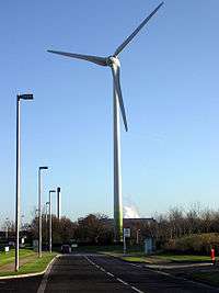
The Green Park Business Park lies half in the Hartley area of Shinfield and half in the Smallmead area of Whitley in Reading. The 2 megawatt (peak) Enercon wind turbine, near Junction 11 of the M4, stands in Shinfield. It has been described as "the UK's most visible turbine". It was constructed in November 2005 and is owned by Ecotricity. The blades are 33 metres (108 ft) long, with a tower height of 85 metres (279 ft). At a wind speed of 14 m/s (31 mph) the machine generates 2.05 MW of electricity (less for lower wind speeds) and has the potential to produce 3.5 million units of electricity a year, enough to power 1,063 local homes. The Courage Berkshire Brewery, built in 1978, is also half within Shinfield but was demolished in 2011.
Transport
Relief road
The Shinfield Eastern Relief Road opened on 31 October 2017.[5] It serves the Shinfield Campus of the University of Reading's Thames Valley Science Park.[6]
Institutions
Churches
- The Church of England parish church of St. Mary is in Church Lane on the west side of the village.
- Shinfield Baptist Church is on Hollow Lane (the main north south route through the village and formerly the A327)
Schools
- Shinfield Infants & Nursery School – built by Richard Piggott in 1707
- Shinfield St Mary's CoE Junior School
- Whiteknights County Primary School
- Crosfields Independent Day School – centred on the early 17th century Goodrest House
- Oakbank School
- Rysh Green School (Defunct)
Sport and leisure
- Shinfield Players Theatre,
- Shinfield Tennis Club, Millworth Lane, Shinfield.
- Shinfield Cricket Club, Millworth Lane. Shinfield.
- Shinfield Rangers FC
- Shinfield FC (Men's team)
- The Shinfield Shambles Border Morris & The Kennet Morris Men
- There are play areas & recreation grounds in Kendal Avenue, Millworth Lane and at Frensham Green and Pearman's Copse
- Pound Green WI and Shinfield Mothers' Union
- Shinfield & District History Society
- Spencers Wood Library
Notable residents
- Shinfield is the current home of Glenn Little (Wrexham FC), Jem Karacan (Reading FC) and Brynjar Gunnarsson (Reading FC).
- Spencers Wood in the parish was the former home of Lenny Henry and Dawn French.
References
- "Civil Parish population 2011". Neighbourhood Statistics. Office for National Statistics. Retrieved 1 December 2016.
- "Amec Foster Wheeler takeover could mean job losses". Get Reading. 14 March 2017. Retrieved 18 August 2019.
- "The Story of the BRO". Berkshire Record Office. Retrieved 18 August 2019.
- Ford, David Nash (2001). "History of Shinfield, Berkshire". Royal Berkshire History. Nash Ford Publishing. Retrieved 28 December 2010.
- http://www.getreading.co.uk/news/reading-berkshire-news/shinfield-relief-road-open-15-13799197
- http://www.tvsp.co.uk/how-find-us/#shinfield-development
- https://bustimes.org.uk/services/3-leopard-reading-aborfield-wokingham
- https://bustimes.org.uk/services/10-leopard-reading-spencers-wood
- https://bustimes.org.uk/services/set_4-10A-_-y08
External links
| Wikimedia Commons has media related to Shinfield. |