Masset
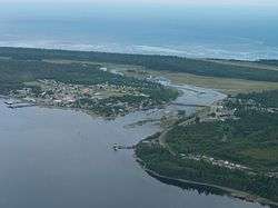
Masset /ˈmæsɪt/, formerly Massett,[3] is a village in Haida Gwaii in British Columbia, Canada. It is located on Masset Sound on the northern coast of Graham Island, the largest island in the archipelago, and is approximately 50 km (31 mi) west of mainland British Columbia. It is the primary western terminus of Trans-Canada Highway 16 (the Yellowhead Highway) and is served by Masset Airport, with flights to Vancouver and Prince Rupert. During the maritime fur trade of the early 19th century, Masset was a key trading site. It was incorporated as a village municipality on May 11, 1961.[4]
Masset | |
|---|---|
| Village of Masset[1] | |
 | |
 Masset Location of Masset in British Columbia  Masset Masset (Canada) | |
| Coordinates: 54°00′36″N 132°08′17″W | |
| Country | Canada |
| Province | British Columbia |
| Region | Haida Gwaii |
| Regional district | Skeena-Queen Charlotte |
| Incorporated | 1961 |
| Government | |
| • Governing body | Masset Village Council |
| • Mayor | Barry Pages |
| Area | |
| • Total | 19.45 km2 (7.51 sq mi) |
| Elevation | 10 m (30 ft) |
| Population (2016)[2] | |
| • Total | 793 |
| • Density | 41/km2 (110/sq mi) |
| Time zone | UTC−8 (PST) |
| • Summer (DST) | UTC-7 (PDT) |
| Highways | |
| Waterways | Dixon Entrance |
| Website | Official website |
Name
The name Masset was a gift from the captain of a Spanish vessel that was repaired with the assistance of the Haida citizens of Atewaas, Kayung and Jaaguhl. These three villages accepted the gift and adopted the name Masset to commemorate what might be the first ever contact between Europeans and the Haida.
During the early years of Canadian colonization the name Masset and the post office were adopted by the former Reverend Charles Harrison as part of his scheme to sell land.
The name Masset is currently in use by the Village of Masset, a municipality under Canada legislation and the Village of Old Massett, the original recipient of the name and a village under the Constitution of the Haida Nation.
According to John T. Walbran,[5]:323 Masset came from the Haida word Masst, or large island. Captain Douglas, on his second visit from Nootka Sound aboard the Iphigenia on June 19, 1789, named the bay leading to the inlet McIntyre's Bay. This name was used on the charts of Dixon and Meares. The American traders called the inlet, Hancock's River as shown in Ingraham's chart of 1792 after the American brig Hancock. In 1853 H.N. Knox of the Royal Navy, mate on HMS Virago, did a sketch survey of the harbour when the name Masset was adopted by the British. A survey was made in 1907 by Captain Learmouth on HMS Egeria.
Masset's name in the local dialect of the Haida language is Uttewas, "white slope", probably referring to a small hill south of the village.[6]
Military base
Canadian Forces Station Leitrim Detachment Masset, established as Naval Radio Station Masset in 1943, is a Canadian Forces facility used to gather signals intelligence for the Communications Security Establishment Canada and the Canadian Forces Intelligence Branch.[7] The equipment at CFS Masset is operated remotely from CFS Leitrim near Ottawa, Ontario.
Notable people from Masset
- Guujaaw (wood carver, musician, traditional medicine practitioner and political activist)
- Michael Nicoll Yahgulanaas (Haida manga artist)
- Robert Davidson (artist)
- Florence Davidson (artist)
- Reg Davidson (carver)
Climate
The climate, moderated by a warm Pacific current from Japan, is generally mild with no extremes in temperature, oceanic (Cfb). Annual temperature varies only 20 degrees Celsius but is variable and unpredictable - even within a 24-hour period. Average rainfall is 1,337.4 mm (52.65 in) with snowfall of 75.3 cm (29.65 in)[8] and there is generally a breeze, most often out of the southeast when it is raining, and the northwest when it is sunny.
Summer temperatures are in the 15 to 20 °C (59 to 68 °F) range and the days are long - May, June, July boasting 18 hours of daylight. August and May general have the most sun but there is a fair degree of rain throughout the summer months. Winter months are mild with temperatures in the 0–8 °C (32–46 °F) range and while precipitation is usually in the form of rain there can be some snowfall. Conditions can become severe without warning and Masset has registered wind gusts to 160 km/h (99 mph).
Although it is located at over 54 degrees north, rainfall follows a Mediterranean pattern. It is one of the northernmost places with this characteristic.
| Climate data for Masset | |||||||||||||
|---|---|---|---|---|---|---|---|---|---|---|---|---|---|
| Month | Jan | Feb | Mar | Apr | May | Jun | Jul | Aug | Sep | Oct | Nov | Dec | Year |
| Record high °C (°F) | 15.6 (60.1) |
14.4 (57.9) |
17.8 (64.0) |
22.2 (72.0) |
25.0 (77.0) |
27.2 (81.0) |
28.3 (82.9) |
28.9 (84.0) |
23.9 (75.0) |
21.7 (71.1) |
18.9 (66.0) |
15.6 (60.1) |
28.9 (84.0) |
| Average high °C (°F) | 5.1 (41.2) |
6.0 (42.8) |
7.2 (45.0) |
9.6 (49.3) |
12.7 (54.9) |
15.3 (59.5) |
17.3 (63.1) |
18.2 (64.8) |
16.1 (61.0) |
12.2 (54.0) |
8.2 (46.8) |
5.9 (42.6) |
11.1 (52.0) |
| Daily mean °C (°F) | 2.4 (36.3) |
3.0 (37.4) |
3.8 (38.8) |
5.8 (42.4) |
8.7 (47.7) |
11.5 (52.7) |
13.7 (56.7) |
14.3 (57.7) |
12.1 (53.8) |
8.5 (47.3) |
5.1 (41.2) |
3.5 (38.3) |
7.8 (46.0) |
| Average low °C (°F) | −2.2 (28.0) |
−0.4 (31.3) |
0.6 (33.1) |
2.1 (35.8) |
4.6 (40.3) |
7.6 (45.7) |
9.9 (49.8) |
10.5 (50.9) |
8.0 (46.4) |
4.8 (40.6) |
2.0 (35.6) |
0.6 (33.1) |
4.8 (40.6) |
| Record low °C (°F) | −18.9 (−2.0) |
−14.4 (6.1) |
−12.8 (9.0) |
−7.8 (18.0) |
−2.8 (27.0) |
0.0 (32.0) |
1.7 (35.1) |
1.7 (35.1) |
−2.8 (27.0) |
−8.3 (17.1) |
−11.1 (12.0) |
−13.3 (8.1) |
−18.9 (−2.0) |
| Average precipitation mm (inches) | 143.3 (5.64) |
111.9 (4.41) |
110.9 (4.37) |
100.9 (3.97) |
80.7 (3.18) |
65.8 (2.59) |
69.7 (2.74) |
72.0 (2.83) |
112.1 (4.41) |
186.4 (7.34) |
181.4 (7.14) |
176.9 (6.96) |
1,412 (55.59) |
| Source: Environment Canada[8][9] | |||||||||||||
See also
References
- "British Columbia Regional Districts, Municipalities, Corporate Name, Date of Incorporation and Postal Address" (XLS). British Columbia Ministry of Communities, Sport and Cultural Development. Archived from the original on July 13, 2014. Retrieved November 2, 2014.
- Statistics Canada. 2016 Census
- "Masset". BC Geographical Names.
- BC Names entry "Masset (Village)"
- Walbran, Captain John T. (1971), British Columbia Place Names, Their Origin and History (Facsimile reprint of 1909 ed.), Vancouver/Toronto: Douglas & McIntyre, ISBN 0-88894-143-9, archived from the original on 2016-03-03, retrieved 2008-07-13
- BC Names entry "Masset (Village)"
- Robinson, Bill (March 1989). "Canada and Signals Intelligence: The Electronic Polar Watch". Ploughshares Monitor: 21–23.
- Environment Canada—, accessed 13 Sept 2015
- Environment Canada—, accessed 2 Nov 2016
| Subdivisions |  | |
|---|---|---|
| Communities | ||
| Metro areas and agglomerations |
| |
| Villages |
| |
| ||