De Beauvoir Town
De Beauvoir Town is a district in east London and is in the London Borough of Hackney, 2 miles (3.2 km) north of the City of London. The area was a part of the Hackney; the Ancient Parish and subsequent Metropolitan Borough that was incorporated into the larger modern borough.
| De Beauvoir Town | |
|---|---|
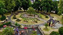
 Aerial view of De Beauvoir Square | |
 De Beauvoir Town Location within Greater London | |
| OS grid reference | TQ3384 |
| • Charing Cross | 3.8 mi (6.1 km) SW |
| London borough | |
| Ceremonial county | Greater London |
| Region | |
| Country | England |
| Sovereign state | United Kingdom |
| Post town | LONDON |
| Police | Metropolitan |
| Fire | London |
| Ambulance | London |
| UK Parliament | |
| London Assembly | |
The name is pronounced variously; notably /də ˈbiːvər/ and /di ˈboʊvwɑːr/, with some who use the former applying the nickname Beavertown.[1]
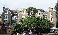
The area was developed in the mid-19th century, much of it as a carefully planned new town designed to attract prosperous residents, although it does include a range of other housing and land use types.
The new town was based around De Beauvoir Square and primarily built in the Jacobethan style. The special character of the neighbourhood has been retained and is recognised by the designation of the De Beauvoir[2] and Kingsland Road[3] Conservation Areas which include many listed and other notable buildings.
Boundaries
Its boundaries are defined by its highly geometric streets and an early 19th century canal. They are: Kingsland Road to the east, Regents Canal to the south, Southgate Road to the west and Balls Pond Road to the north; the middle of the last two roads marks the border of the London Boroughs of Hackney and Islington. The area enclosed by these roads is just over 0.7 square kilometres (0.27 sq mi). Direct neighbours are Canonbury, Dalston and Shoreditch (the latter's Hoxton and Haggerston areas).
History
19th century
Until 1820 the area now covered by De Beauvoir Town was open country with a few grand houses. In 1821, stimulated by the opening of the Regent's Canal the previous year, developer and brickmaker William Rhodes (1774-1843), a grandfather of Cecil Rhodes,[4] secured a lease for 150 acres (0.61 km2) of land from Peter de Beauvoir.[5] Rhodes planned to build residences for the upper classes set on wide streets in a grid pattern, with four squares on diagonal streets intersecting at an octagon. However, work stopped in 1823 when Rhodes was found to have obtained his lease unfairly and after a court case spanning over 20 years the land reverted to the de Beauvoir family in 1834.[6]
The delay in the building had meant that Rhodes' clientele had since moved on to the new suburbs of the West End. The scheme was scaled down and of the planned squares only the southeastern was built, as De Beauvoir Square, although the diagonals partly survived in Enfield Road, Stamford Road and Ardleigh Road. Occupied in the 1840s by the newly emerging middle classes, the estate was almost wholly residential except around Kingsland Basin and the south-west corner where a factory was leased from 1823.[6]
20th Century

In 1937, due to its easy access to Kingsland Basin, the southeast corner between Downham Road and Hertford Road was re-zoned for industrial use. Soon after the areas south of Downham Road were included. These were distinguished from the north side, which was already zoned for business and acted as a buffer for the mainly residential streets beyond. In 1938 De Beauvoir Crescent was suggested as another business zone to protect housing to the north.
In the early 1960s the northern part of De Beauvoir Town between Buckingham Road and Tottenham Road was rebuilt as the Metropolitan Borough of Hackney's Kingsgate estate. In the late 1960s a larger area west of the canal basin, which contained many small factories, made way for the De Beauvoir Estate. The east side of De Beauvoir Square was also rebuilt as the Lockner Road estate.
In 1968 the De Beauvoir Association was formed to fight Hackney Councils plans to demolish the area and build new build council estates on it. The rest of the square with the area bounded by Englefield Road, Northchurch Road, Southgate Road, Hertford Road, and Stamford Road became a conservation area in 1969. This area was later extended to cover most of De Beauvoir Town; the eastern edge, however, is in the Kingsland conservation area.
In the 1970s the Greater London Council installed experimental design measures in De Beauvoir Town to reduce through vehicle traffic and make streets safer for children's play. These were designed by the architect Graham Parsey who lived in the area and was chairman of the De Beauvoir Association. This included filtered permeability measures on roads including Downham Road and Northchurch Road.[8]
In the arts

The music video to accompany the release of "Stay With Me" by Sam Smith shows Smith coming out of a house and walking down a street in De Beauvoir Town. It was directed by Jamie Thraves.[9]
Parts of the feature film 28 Weeks Later were filmed in De Beauvoir Town.[10]
Notable residents
Edmund Gosse, the poet, the son of naturalist Philip Henry Gosse, lived in the area. Tony Calvert, co-founder of Terrence Higgins Trust, lives in the area.
Graham Parsey (1938-2011), architect, journalist, local campaigner and Chairman of the De Beauvoir Association, who from the late 1960's with the formation of the DBA (De Beauvoir Association) worked to make the area a GIA (General Improvement Area) and therefore saved the whole area from demolition by Hackney Council. He stood at three Public Inquiries as an expert witness and led and organised a successful community campaign to oppose the demolition of six hundred houses. The status of De Beauvoir as a conservation area, the fact that the area still stands in its present form is because of his work. He self-published the De Beaver newspaper which was the hub of local activity. He also designed and implemented all the cycle pathways and traffic calming measures in the 1970s, which is such a feature of the area today.
De Beauvoir Town was home to William Lyttle (1931–2010), a retired electrical engineer known as the Mole Man of Hackney, who dug a series of tunnels under his 20-room property on the corner of Mortimer Road and Stamford Road. In 2001, his tunnelling caused an 8 ft (2.4 m) hole to appear in the pavement on Stamford Road. Reports that the tunnelling had started again in 2006 were confirmed when Hackney Council found a network of tunnels and caverns, some 8 m (26 ft) deep, spreading up to 20m in every direction from his house. In August 2006, the council obtained a court order banning Lyttle from his property. He died in 2010 and the fate of the house, by now derelict and needing a new roof, was thought to be uncertain.[11][12][13] On 19 July 2012 the house was sold at auction for £1.12 million.[14]. By 2020, the house had been renovated by the architect David Adjaye to form a home and studio for the artist Sue Webster.[15]
Elected representatives
The local MP is Meg Hillier. Two local councillors serve the similar 'De Beauvoir ward', which are, as of 2017, James Peters[16] and Laura Bunt.[17][18][19]
Education
Transport and locale
Neighbouring areas of London. | ||||||||||
|---|---|---|---|---|---|---|---|---|---|---|
| ||||||||||

- Nearest Railway Stations
- Essex Road, services operated by Great Northern to Welwyn Garden City
- Canonbury, services operated by London Overground
- Dalston Junction, services operated by London Overground
- Haggerston, services operated by London Overground
- Nearest London Underground Stations
- Angel, served by Northern line
- Old Street, served by Northern line and Great Northern trains
- Highbury & Islington, served by Victoria line and Great Northern trains
- Nearby Bus Routes
The area is well served by London Buses.
|
|
|
Walking and cycling
The Regents Canal towpath is easily accessible to pedestrians and cyclists. Travelling east, provides access to Victoria Park, and to the west, Islington.
References
- Guardian article on the origins of the Beavertown brewery which began in the area https://www.theguardian.com/lifeandstyle/2014/apr/11/craft-ales-beavertown-brewery-logan-plant-behind-the-scenes
- Local authority website with details of the conservation area https://www.hackney.gov.uk/debeauvoir-ca
- Local authority website with details of the conservation area https://www.hackney.gov.uk/kingsland-ca
- William Rhodes' eldest son, Rev. Francis William Rhodes (1807-1878), was the father of Cecil
- http://www.hackney.gov.uk/Assets/Documents/ep-de-beauvoir-appraisal.pdf Archived 24 September 2015 at the Wayback Machine, (De Beauvoir Conservation Area Extension, Conservation Area Appraisa, London Borough of Hackney, 1998)
- Hackney: De Beauvoir Town, A History of the County of Middlesex: Volume 10: Hackney (1995), pp. 33-35 accessed: 7 March 2009
- De Beauvoir Estate at Emporis
- Hackney Cyclist http://hackneycyclist.blogspot.com/2015/10/the-history-behind-filtered.html
- "Sam Smith - Stay With Me (Behind the Scenes Video)". YouTube. Retrieved 8 May 2015.
- The Horror and heartache, Karyn Michael, Hackney Today, Issue 158, p.5, 7 May 2007
- After 40 years' burrowing, Mole Man of Hackney is ordered to stop The Guardian
- Mole Man faces £100,000 bill for undermining the neighbourhood The Times Online-
- Lewis, Paul (18 June 2010). "Hunt for heirs after Hackney 'mole man' William Lyttle dies". The Guardian. London.
- "'Mole Man' home in Hackney sold for £1.12m". BBC News. 19 July 2012. Retrieved 19 July 2012.
- "David Adjaye renovates Mole House undermined by illegal secret tunnels". Dezeen. 4 February 2020. Retrieved 4 February 2020.
- 1 (7 June 2019). "Hackney Council - Councillor details - Councillor James Peters". mginternet.hackney.gov.uk.CS1 maint: numeric names: authors list (link)
- "- Hackney Council". www.hackney.gov.uk.
- 1 (7 June 2019). "Hackney Council - Your Councillors". mginternet.hackney.gov.uk.CS1 maint: numeric names: authors list (link)
- "What's happening in De Beauvoir". debeauvoircouncillors.blogspot.co.uk.
External links
- Projects Filmed in De Beauvoir
- Brickfields: Georgian landscape (Building Exploratory, n.d.)
- The De Beauvoir Association (includes further information and image of William Rhodes' original plans)

| Districts |  | |
|---|---|---|
| Attractions |
| |
| Street markets | ||
| Parks and open spaces |
| |
| Constituencies | ||
| Tube and rail stations | ||
| Other topics | ||
| ||