Lambton Shores
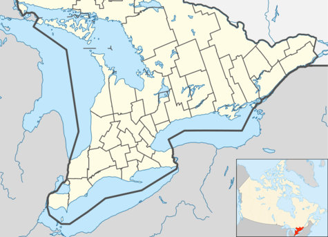
Lambton Shores is a municipality in Lambton County, Ontario, Canada, that is on the southern shores of Lake Huron.
Lambton Shores | |
|---|---|
| Municipality of Lambton Shores | |
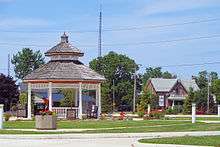
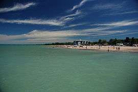 Grand Bend | |
 Lambton Shores | |
| Coordinates: 43°11′N 81°54′W | |
| Country | |
| Province | |
| County | Lambton |
| Formed | 2001 |
| Government | |
| • Mayor | Bill Weber |
| • Federal riding | Lambton—Kent—Middlesex |
| • Prov. riding | Lambton—Kent—Middlesex |
| Area | |
| • Land | 331.20 km2 (127.88 sq mi) |
| Population (2016)[1] | |
| • Total | 10,631 |
| • Density | 32.1/km2 (83/sq mi) |
| Time zone | UTC-5 (EST) |
| • Summer (DST) | UTC-4 (EDT) |
| Postal Code | N0N 1J 0-9/N0M |
| Area code(s) | 519 and 226 |
| Website | www.lambtonshores.ca |
History
Lambton Shores was formed in 2001 when the Township of Bosanquet was amalgamated with the town of Forest, and the villages of Thedford, Arkona, Ipperwash, Port Franks, Ravenswood and Grand Bend.
Climate
Lambton Shores is one of the more southerly municipalities in Canada, and therefore receives relatively warmer temperatures. It has an average high of 26 °C (79 °F) in July and −1 °C (30 °F) in January. As for precipitation, it receives an average of 87 millimetres (3.4 in) of rain in July and an average of 45 centimetres (18 in) of snow in January.
| Climate data for Thedford (1981−2010) | |||||||||||||
|---|---|---|---|---|---|---|---|---|---|---|---|---|---|
| Month | Jan | Feb | Mar | Apr | May | Jun | Jul | Aug | Sep | Oct | Nov | Dec | Year |
| Record high °C (°F) | 15.0 (59.0) |
21.5 (70.7) |
27.0 (80.6) |
30.0 (86.0) |
33.0 (91.4) |
38.0 (100.4) |
36.5 (97.7) |
37.0 (98.6) |
34.0 (93.2) |
29.5 (85.1) |
23.0 (73.4) |
17.5 (63.5) |
38.0 (100.4) |
| Average high °C (°F) | −0.9 (30.4) |
0.0 (32.0) |
5.1 (41.2) |
12.2 (54.0) |
18.9 (66.0) |
24.5 (76.1) |
26.6 (79.9) |
25.6 (78.1) |
21.9 (71.4) |
14.7 (58.5) |
7.7 (45.9) |
1.3 (34.3) |
13.2 (55.8) |
| Daily mean °C (°F) | −4.2 (24.4) |
−3.8 (25.2) |
0.7 (33.3) |
7.1 (44.8) |
13.1 (55.6) |
18.7 (65.7) |
21.0 (69.8) |
20.2 (68.4) |
16.4 (61.5) |
10.2 (50.4) |
4.3 (39.7) |
−1.6 (29.1) |
8.5 (47.3) |
| Average low °C (°F) | −7.5 (18.5) |
−7.6 (18.3) |
−3.7 (25.3) |
1.9 (35.4) |
7.2 (45.0) |
12.7 (54.9) |
15.4 (59.7) |
14.6 (58.3) |
10.8 (51.4) |
5.6 (42.1) |
0.9 (33.6) |
−4.5 (23.9) |
3.8 (38.8) |
| Record low °C (°F) | −33 (−27) |
−30 (−22) |
−23.5 (−10.3) |
−9 (16) |
−2.5 (27.5) |
1.5 (34.7) |
6.0 (42.8) |
5.0 (41.0) |
−1.5 (29.3) |
−5.5 (22.1) |
−13 (9) |
−25.5 (−13.9) |
−33 (−27) |
| Average precipitation mm (inches) | 73.8 (2.91) |
57.6 (2.27) |
57.6 (2.27) |
78.9 (3.11) |
80.9 (3.19) |
76.4 (3.01) |
87.2 (3.43) |
79.7 (3.14) |
103.0 (4.06) |
94.3 (3.71) |
89.5 (3.52) |
84.5 (3.33) |
963.3 (37.93) |
| Average rainfall mm (inches) | 29.1 (1.15) |
23.7 (0.93) |
35.3 (1.39) |
74.7 (2.94) |
80.9 (3.19) |
76.4 (3.01) |
87.2 (3.43) |
79.7 (3.14) |
103.0 (4.06) |
92.9 (3.66) |
77.8 (3.06) |
42.9 (1.69) |
803.4 (31.63) |
| Average snowfall cm (inches) | 44.7 (17.6) |
33.9 (13.3) |
22.3 (8.8) |
4.2 (1.7) |
0.0 (0.0) |
0.0 (0.0) |
0.0 (0.0) |
0.0 (0.0) |
0.0 (0.0) |
1.4 (0.6) |
11.7 (4.6) |
41.7 (16.4) |
159.9 (63.0) |
| Average precipitation days (≥ 0.2 mm) | 14.5 | 10.8 | 12.8 | 13.4 | 12.8 | 10.9 | 11.1 | 10.9 | 12.4 | 15.0 | 15.1 | 14.5 | 153.9 |
| Average rainy days (≥ 0.2 mm) | 4.6 | 3.4 | 7.3 | 12.6 | 12.8 | 10.9 | 11.1 | 10.9 | 12.4 | 14.9 | 12.7 | 6.8 | 120.1 |
| Average snowy days (≥ 0.2 cm) | 10.6 | 8.3 | 6.3 | 1.5 | 0.0 | 0.0 | 0.0 | 0.0 | 0.0 | 0.38 | 3.0 | 9.0 | 38.8 |
| Source: Environment Canada[2] | |||||||||||||
Communities
The main communities in Lambton Shores are Arkona, Forest, Grand Bend, Port Franks and Thedford. Smaller communities include Cedarview, Glendale Beach, Kettle and Stoney Point, Ipperwash Beach, Lake Valley Grove, Jericho, Jura, Kinnaird, Northville, Ravenswood, Southcott Pines, Springvale, Sunnidale, Walden Place and Walker Woods. The administrative offices of the township are located in Thedford.
Arkona
Arkona is a community located in the municipality of Lambton Shores in southwestern Ontario near the Lambton–Middlesex county line, situated beside the Ausable River, on Former Kings Highway 79 (now Lambton County Road 79), Arkona is roughly halfway between Thedford, and Watford.

Forest
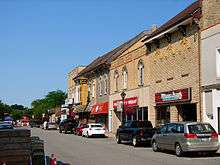
Forest is situated on what was once dense forest. When the Grand Trunk Railway was built through where the town now sits, the station was named for the dense forest. Hickory Creek, which meanders through the town, provided water for the station in those days when wood and water were essential to the operation of steam locomotives.
Grand Bend
The settlement began in the 1830s when a group of English and Scottish settlers bought lots from the Canada Company, a land development firm. One of the original settlers, Benjamin Brewster gave his name to the village after he and his business partner David Smart secured rights to dam the Ausable River and started a sawmill in 1832. The villagers were mainly the families of the millhands and fisherman. Their homesteads were situated on the south side of the present village.
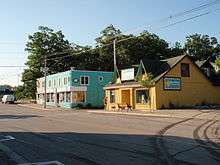
Thedford
Thedford is a small community in northwestern Lambton County, Ontario Canada, situated 8 km south of Kings Highway 21, along Lambton CR 79 (Former Kings Highway 79). The community began in the 1860s when farmer Nelson Southworth, a native of Vermont, agreed to donate land for the construction of a Grand Trunk Railway station, with the condition that he would be able to name it. Southworth chose the name "Thetford", as a way of honouring Thetford, Vermont, a community in his home state in the United States. A local clerk's poor hand writing was mistaken for the current spelling, which is how it first appeared on official records. The Thedford Raiders Hockey Team once held the World Record for Longest Continuous Hockey Game, which was also a fundraiser for juvenile diabetes. A plaque at the entrance of the town heralds it as the "Onion Capital of Canada".
A designated place within the municipality of Lambton Shores, Thedford had a population of 822 in the Canada 2006 Census.
Thedford telephone numbers start with 519-296.
Demographics
| Canada census – Lambton Shores community profile | |||
|---|---|---|---|
| 2016 | 2011 | 2006 | |
| Population: | 10,631 (-0.2% from 2011) | 10,656 (-4.4% from 2006) | 11,150 (5.5% from 2001) |
| Land area: | 331.20 km2 (127.88 sq mi) | 331.08 km2 (127.83 sq mi) | 331.08 km2 (127.83 sq mi) |
| Population density: | 32.1/km2 (83/sq mi) | 32.2/km2 (83/sq mi) | 33.7/km2 (87/sq mi) |
| Median age: | 54.7 (M: 53.6, F: 55.4) | 52.4 (M: 51.6, F: 53.3) | 49.4 (M: 48.5, F: 50.3) |
| Total private dwellings: | 7008 | 6880 | 6773 |
| Median household income: | $67,264 | $51,328 | |
| References: 2016[3] 2011[4] 2006[5] earlier[6] | |||
| Historical population | ||
|---|---|---|
| Year | Pop. | ±% |
| 1996 | 10,874 | — |
| 2001 | 10,571 | −2.8% |
| 2006 | 11,150 | +5.5% |
| 2011 | 10,656 | −4.4% |
| 2016 | 10,631 | −0.2% |
| [7][4][1] | ||
Media
There are two radio stations that originate from Lambton Shores
90.5 myFM Exeter/Grand Bend Local News
- CKTI-FM, a First Nations station from Kettle Point
- VFR895, a race info station from Grand Bend Motorplex
There are two newspapers that originate from Lambton Shores
- Lakeshore Advance, owned by Sun Media
- Standard Guide Advocate, owned by Hayter Walden Publications
See also
References
- "Census Profile, 2016 Census: Lambton Shores, Municipality". Statistics Canada. Retrieved June 17, 2019.
- "Thedford, Ontario". Canadian Climate Normals 1981–2010. Environment Canada. Retrieved February 8, 2014.
- "2016 Community Profiles". 2016 Canadian Census. Statistics Canada. February 21, 2017. Retrieved 2018-12-28.
- "2011 Community Profiles". 2011 Canadian Census. Statistics Canada. July 5, 2013. Retrieved 2012-08-08.
- "2006 Community Profiles". 2006 Canadian Census. Statistics Canada. March 30, 2011. Retrieved 2011-02-18.
- "2001 Community Profiles". 2001 Canadian Census. Statistics Canada. February 17, 2012.
- Statistics Canada: 1996, 2001, 2006 census
External links
Places adjacent to Lambton Shores | ||||||||||
|---|---|---|---|---|---|---|---|---|---|---|
| ||||||||||