La Paz, Baja California Sur
La Paz (pronounced [la ˈpas] (![]()
La Paz | |
|---|---|
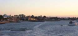 La Paz beach and its docks | |
 Coat of arms | |
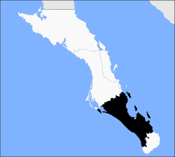 Location of La Paz in Baja California Sur | |
La Paz Location of La Paz in Mexico | |
| Coordinates: 24°08′32″N 110°18′39″W | |
| Country | Mexico |
| State | Baja California Sur |
| Municipality | La Paz |
| Founded | May 3, 1535 |
| named La Paz | 1596 |
| Government | |
| • Municipal president | Rubén Muñoz (MORENA) |
| Elevation | 27 m (89 ft) |
| Population (2015 [1]) | |
| • City | 244,219 [1] |
| • Metro | 290,286 [1] |
| Data source: INEGI | |
| Time zone | UTC−07:00 (MST) |
| • Summer (DST) | UTC−06:00 (MDT) |
| Website | www |
| Source: Enciclopedia de los Municipios de México | |
The population of La Paz has grown greatly since the 2000s. The growth is largely because the city has one of the highest standards of living and security in Mexico.
La Paz is served by the Manuel Márquez de León International Airport with flights to the most important cities of Mexico: Mexico City, Guadalajara, Monterrey. Airlines flying into La Paz include Aeroméxico Connect, Volaris and VivaAerobus. Two ferry services operate from the port of Pichilingue outside the city, connecting the Baja California peninsula to the mainland at Mazatlán and Topolobampo, near Los Mochis.
Geography

La Paz is located on the Baja California peninsula on the Bay of La Paz, 210 kilometres (130 mi) south of Ciudad Constitución, municipality of Comondú, and 202 kilometres (126 mi) north of Cabo San Lucas, municipality of Los Cabos. It is located 81 kilometres (50 mi) north of the town of Todos Santos. Its geographical coordinates are 24°08′32″ N and parallel 110°18′39″W, it has an altitude of 0 to 27 meters above the sea level. It is one of the three state capitals of Mexico that are on the coast of the sea.
History
Spanish discovery
.jpg)


The first European known to have landed in Baja California was Fortún Ximénez. In 1533, shortly after the conquest of Tenochtitlan, Hernán Cortés sent two ships, Concepción, under the command of captain and commander of the expedition, Diego de Becerra, and San Lázaro under Capt. Hernando de Grijalva, to explore the South Seas of the Pacific Ocean. The ships set out November 30, 1533, to travel north along the coast of New Spain from present-day Manzanillo, Colima, in search of two ships that had been lost without a trace on a similar voyage the previous year. By December 20 the ships had separated; San Lázaro, which had gone ahead, waited three days for Concepción and after no sighting of its companion vessel, Capt. Grijalva dedicated himself to exploring the region and discovered the Revillagigedo Islands. On board the Concepción, the navigator and second in command, Fortún Jiménez, led a mutiny in which Capt. Becerra was killed, then attacked the crewmen loyal to the murdered captain, abandoning the wounded on the coast of Michoacán along with the friars Franciscans who had accompanied him the expedition.
Jiménez sailed to the northwest following the coast and at some point turned west and reached a bay that is now the port of the city of La Paz. Jiménez thought that he had found an island, and never knew that it was a large peninsula. There he met natives who wore few clothes and spoke an unknown language; their culture was very different from that of the inhabitants of the Mexican highlands. The sexually deprived crews of his ships saw the scantily-clad women and took them by force. The Spaniards soon became aware of the large pearls that the natives extracted from the pearl oysters abounding in the bay, and proceeded to plunder the people and rape their women. Jiménez and his men did not name any of the places they found, it would be left to other explorers to name the places visited by Fortún Jiménez.
The abuse of the Indian women by the crew and their looting caused a violent confrontation with the natives that ended in the deaths of Fortún Jiménez and some of his companions; the survivors withdrew, and sailed erratically for several days until they reached the shores of the present-day Jalisco, where they encountered a subaltern of Nuño de Guzmán, who requisitioned the ship and took them prisoner.
Hernán Cortés arrives in California and founds the town of Santa Cruz
Having sponsored two exploratory voyages in the South Seas with no material results, Cortés decided to lead a third exploration himself. Annoyed that his enemy, Nuño de Guzmán, had requisitioned one of his ships during the first expedition, Cortés decided to confront Guzmán on his own ground and from there set up the third expedition; consequently he prepared a large force of infantry and cavalry to march on the province of New Galicia, of which Guzmán was governor.
The viceroy of New Spain, Antonio de Mendoza, warned Cortés on September 4, 1534, "not to confront he who had requisitioned his ships", a warning which Hernán Cortés ignored, claiming that he had been designated to conquer and discover new territories, and that he had spent more than 100 thousand gold ducats of his own fortune. The feared confrontation between the armies of Cortés and Nuño de Guzmán did not occur.
In Chametla, (Sinaloa), after crossing the present-day states of Jalisco and Nayarit, territory then known as part of New Galicia, Cortés and his entourage embarked the ships Santa Águeda and San Lázaro with 113 crewmen and 40 cavalrymen with their horses and gear, leaving 60 riders on land, as reported to the Real Audiencia and Governor Nuño de Guzmán. Cortés then sailed in a northwestly direction, and on May 3, 1535 arrived at the bay he named Bahia de la Santa Cruz (Bay of Santa Cruz), currently the port of La Paz, where he confirmed the death of his subordinate, Fortún Jiménez, at the hands of the natives. Once Cortés had taken possession of the bay, he decided to establish a colony and summoned the soldiers and arms he had left in Sinaloa. The transport ships were lost in a storm, however, and only one ship, carrying a load of fifty bushels of corn, returned. This was insufficient to feed the population, so Cortés left to personally secure food, but was unable to procure enough, so he decided to return to New Spain with the intention of supplying the new colony from there.
Francisco de Ulloa was in command of the town of La Paz, but complaints by relatives of those who had stayed on the peninsula caused the viceroy to order the population to abandon the colony and return to New Spain. Following this failure of Cortés' third expedition to establish a colony in the newly discovered lands that belonged to him by royal decree, an enemy of Cortés, whom a writer of the time cites as Alarcón, gave the name of the abandoned land in a mocking tone as California to insult him.
The Baja California peninsula, the Gulf of California (also known as the Sea of Cortez), and the states of California, Baja California and Baja California Sur, bear the name today.
From January 10, 1854, to May 8, 1854, La Paz served as the capital of William Walker's Republic of Sonora. The project collapsed due to lack of US support and pressure from the Mexican government to retake the region.
Climate

La Paz has a desert climate. The climate of La Paz is relatively consistent with generally little rainfall, with a year around average temperature of between 17 and 30 °C (63 and 86 °F). Summer months (July–September) typically see highs between 34 and 36 °C (93 and 97 °F) and dew points of 21–23 °C (70–73 °F).[3] The winter months (December–February) are the coldest with temperatures dropping below 15 °C (59 °F) at night, but mostly maxima are from 20 to 25 °C (68 to 77 °F). Breezes from Bahía de La Paz moderate the temperature. The bay also acts as a barrier against seasonal storms in the Gulf of California.
Rainfall is minimal at most times of year, although erratic downpours can bring heavy rains. Rain tends to be concentrated in a short, slightly rainier season that peaks in August and September, following the pattern of the North American Monsoon. The driest season, where it is common to have no rain, occurs March through June. La Paz averages over 300 days of sunshine annually and an average of 3148 sunshine hours.
During the summer the cooling Coromuel winds, a weather phenomenon unique to the La Paz area, blow during the night from the Pacific over the Peninsula and into the Bay of La Paz.
As with most of the Gulf of California, the temperature of the water changes substantially over the course of the year, with temperatures around 68 °F (20 °C) during winter and around 85 °F (29 °C) during summer.[4][5][6][7]
| Climate data for La Paz (1951–2010) | |||||||||||||
|---|---|---|---|---|---|---|---|---|---|---|---|---|---|
| Month | Jan | Feb | Mar | Apr | May | Jun | Jul | Aug | Sep | Oct | Nov | Dec | Year |
| Record high °C (°F) | 35.2 (95.4) |
37.4 (99.3) |
38.2 (100.8) |
41.0 (105.8) |
41.0 (105.8) |
43.0 (109.4) |
43.0 (109.4) |
43.0 (109.4) |
43.0 (109.4) |
43.5 (110.3) |
38.5 (101.3) |
36.0 (96.8) |
43.5 (110.3) |
| Average high °C (°F) | 23.6 (74.5) |
24.9 (76.8) |
27.3 (81.1) |
30.3 (86.5) |
33.4 (92.1) |
35.6 (96.1) |
36.6 (97.9) |
36.2 (97.2) |
35.0 (95.0) |
32.6 (90.7) |
28.3 (82.9) |
24.4 (75.9) |
30.7 (87.3) |
| Daily mean °C (°F) | 17.4 (63.3) |
18.1 (64.6) |
19.7 (67.5) |
22.1 (71.8) |
24.5 (76.1) |
27.1 (80.8) |
29.7 (85.5) |
30.2 (86.4) |
29.3 (84.7) |
26.2 (79.2) |
22.0 (71.6) |
18.6 (65.5) |
23.7 (74.7) |
| Average low °C (°F) | 11.2 (52.2) |
11.3 (52.3) |
12.1 (53.8) |
13.9 (57.0) |
15.7 (60.3) |
18.6 (65.5) |
22.9 (73.2) |
24.1 (75.4) |
23.5 (74.3) |
19.9 (67.8) |
15.7 (60.3) |
12.8 (55.0) |
16.8 (62.2) |
| Record low °C (°F) | 2.0 (35.6) |
2.5 (36.5) |
3.0 (37.4) |
4.5 (40.1) |
8.5 (47.3) |
10.0 (50.0) |
11.5 (52.7) |
13.0 (55.4) |
12.0 (53.6) |
10.0 (50.0) |
6.5 (43.7) |
2.0 (35.6) |
2.0 (35.6) |
| Average rainfall mm (inches) | 14.2 (0.56) |
5.3 (0.21) |
2.3 (0.09) |
0.8 (0.03) |
0.9 (0.04) |
1.3 (0.05) |
14.5 (0.57) |
37.2 (1.46) |
58.4 (2.30) |
12.1 (0.48) |
7.4 (0.29) |
14.8 (0.58) |
169.2 (6.66) |
| Average rainy days (≥ 0.1 mm) | 1.8 | 1.1 | 0.4 | 0.2 | 0.1 | 0.2 | 2.1 | 4.1 | 4.1 | 1.5 | 0.8 | 1.8 | 18.2 |
| Average relative humidity (%) | 66 | 60 | 58 | 55 | 55 | 54 | 58 | 61 | 63 | 63 | 64 | 66 | 60 |
| Mean monthly sunshine hours | 228 | 241 | 291 | 305 | 334 | 334 | 298 | 268 | 254 | 279 | 245 | 210 | 3,287 |
| Source 1: Servicio Meteorológico Nacional (humidity 1981–2000)[8][9][10] | |||||||||||||
| Source 2: Ogimet (sun 1981–2010)[11] | |||||||||||||
| Jan | Feb | Mar | Apr | May | Jun | Jul | Aug | Sep | Oct | Nov | Dec |
|---|---|---|---|---|---|---|---|---|---|---|---|
| 68 °F 20 °C |
66 °F 19 °C |
68 °F 20 °C |
72 °F 22 °C |
75 °F 24 °C |
79 °F 26 °C |
82 °F 28 °C |
84 °F 29 °C |
86 °F 30 °C |
84 °F 29 °C |
79 °F 26 °C |
72 °F 22 °C |
Economy
.jpg)

The population of La Paz has grown greatly since the 2000s.
Eco-tourism is by far the most important source of tourism income in La Paz. Tourists also visit the city's balnearios. There are some 900 islands and inlets in the Gulf of California with 244 now under UNESCO protection as World Heritage Bio-Reserves and the Isla Espíritu Santo group, which borders the northeast portion of the Bay of La Paz, the primary tourist destination of the area.
Industries include silver mining, agriculture, fishing and pearls. Tourism is also an important source of employment for this coastal community.
Along with the area's marinas, new developments are emerging because of the proximity to the United States.
When Aero California existed, its headquarters were in La Paz.[12]
Transportation
.jpg)
La Paz is served by Manuel Márquez de León International Airport with flights to the most important cities of Mexico: Mexico City, Guadalajara, Monterrey. Airlines flying into La Paz include Aeroméxico Connect, Volaris and VivaAerobus. Two ferry services operate from the port of Pichilingue outside the city, connecting the Baja California peninsula to the mainland at Mazatlán and Topolobampo, near Los Mochis.
Roads
Running along the coast in front of La Paz is 5 km (3.1 mi) long Malecon Road. The main purpose of this road is to allow easy movement across the city. However, it quickly became the focal point of tourist related activities with a large number of bars, restaurants and shops opening along its length. Since 2004 extensive development has taken place which included a large sidewalk which offers safety for large numbers of people to walk along the coastal front of La Paz.
In September 2011, a bicycle lane was added to Malecon Road, providing cyclists protection from cars and pedestrians.
La Paz is served mainly by two highways; Mexican Federal Highway 1 that links the south of the state from Cabo San Lucas to the north of the peninsula to Tijuana, and Mexican Federal Highway 19, that connects La Paz with the population of the south pacific towns such as Todos Santos and El Pescadero. It is also served by two secondary roads, the Los Planes highway (286) that connects La Paz with towns such as La Ventana, Ensenada de los Muertos and Los Planes. The other is the Pichilingue highway which links La Paz with its maritime port.
Gastronomy
.jpg)
Local cuisine is characterized by seafood dishes, especially of lobster, sole, clams and shrimp. Oregano is frequently used as a spice, and damiana, an ingredient in a traditional liqueur, is widely regarded as an aphrodisiac and brewed as a tea.
Regional cuisine also includes traditional dishes such as machaca, made from beef that has been well-cooked, shredded, and then cooked in its own juices, fresh cheeses and the typical flour tortillas. Abundantly available clams are prepared in various ways such as pickling, breading and frying, or stuffing. Shrimp are plentiful also, and eaten grilled, fried, or baked as in the regional specialty, filete imperial de camarones. Other popular seafood dishes include callo garra de león, made with scallops, fish tatemado, and ceviche.
Regional sweets are represented by fruits such as guava, mango and pitaya, green papaya and fig in syrup, as well as dehydrated regional fruits such as white fig and mango. Cheese empanadas (empanadas de queso) and empanadas made with sweet beans are also popular.
Demographics
The city had a 2015 census population of 244,219 inhabitants,[1] making it the most populous city in the state. Its metropolitan population is somewhat larger because of surrounding towns, such as El Centenario (pop. 6,068), Chametla (pop. 1,731 as of 2010) and San Pedro. Its surrounding municipality, which is the fourth-largest municipality in Mexico in geographical size, reported a population of 290,286 inhabitants.
| Historical population | ||
|---|---|---|
| Year | Pop. | ±% |
| 1960 | 24,253 | — |
| 1970 | — | |
| 1980 | — | |
| 1990 | 136,759 | — |
| 1995 | 154,314 | +12.8% |
| 2000 | 162,954 | +5.6% |
| 2005 | 189,178 | +16.1% |
| 2010 | 215,178 | +13.7% |
| 2015 | 244,219 | +13.5% |
| Sources:[13][14] | ||
Education
La Paz is the state capital and center of commerce, as well as the home of the three leading marine biology institutes in Latin America (UABCS, CIBNOR & CICIMAR), largely because it sits on the Gulf of California, which is home to exceptional marine biodiversity. It also supports several other university-level institutes of learning, such as the Universidad Autonoma de Baja California Sur.
La Paz is the headquarters of several higher education centers, the main ones being:
- Universidad Autónoma de Baja California Sur (UABCS)
- Universidad Tecnológica de La Paz (UTLP)
- Instituto Tecnológico de La Paz (ITLP)
- Universidad Mundial (UM)
- Centro Interdisciplinario de Ciencias Marinas (CICIMAR)
- Centro de Investigaciones Biológicas del Noroeste (CIBNOR)
- Centro de Investigación Científica y de Educación Superior de Ensenada (CICESE) Campus La Paz
- Benemérita Escuela Normal Urbana Prof. Domingo Carballo Félix (BENU)
- Escuela Normal Superior del Estado de Baja California Sur (ENSBCS).
- Universidad Internacional de La Paz (UNIPAZ)
- Universidad de Tijuana Campus La Paz (CUT)
- Tecnológico de Baja California.
- Universidad Católica Campus La Paz.
- Universidad del Desarrollo Profesional (UNIDEP) Plantel La Paz
- Universidad Intercontinental
- Instituto Mar de Cortés.
- Instituto Cultural Tecnológico Cuincacalli (ICTEC)
- Centro de Capacitación para el Trabajo Industrial (CECATI 39)
- Escuela Superior de Cultura Física para Baja California Sur (ESCUFI).
- Universidad Tecnológica de La Paz (UTLP)
Health
La Paz has several medical centers; the Secretariat of Health operates the Juan María de Salvatierra general hospital, which has medical specialists and an exclusive area for pediatric oncology, as well as a unit that provides medical care under the national health insurance program, as well as a hemodialysis unit, a blood bank, a mental health division, health centers and other units. The Mexican Social Security Institute (IMSS) provides a family clinic and an ambulatory medical unit in which ambulatory surgeries are performed. There is also a new ISSSTE hospital, the Naval Sanatorium, and the Secretariat of National Defense hospital, which offers external consultation services, hospitalization and medical specialists.
Reflecting high national rates, there are similarly high local rates of diabetes mellitus, arterial hypertension, and renal insufficiency, as well as of automobile accidents resulting in injury, despite public health dissemination programs and driver education programs.
According to the Baja California Sur State Development Plan 2005-2011, during 2006 there were 24 deaths due to cervical cancer in the state. The health sector seeks to reduce cervical cancer mortality by providing timely treatment to women aged 25 to 64 years, and improving the efficiency of diagnostic laboratories and the monitoring of patients.
In popular culture
John Steinbeck visited La Paz in 1940. He describes the town in his 1947 novel The Pearl and mentions it extensively in his 1951 travelogue The Log from the Sea of Cortez.[15]
The city is also the setting of the 1967 Scott O'Dell children's novel The Black Pearl, chosen as a Newbery Honor Book in 1968;[16] La Paz is the home of the main character.
Sister cities

See also
References
- "Data" (PDF). www.saludbcs.gob.mx. Archived from the original (PDF) on 2018-01-21. Retrieved 2018-01-20.
- (in Spanish) Los Municipios con Mayor y Menor Extensión Territorial Archived 2007-03-03 at the Wayback Machine, Instituto Nacional Para el Federalismo y el Desarrollo Municipal, SEGOB (Mexico.) Accessed 15 February 2008.
- "La Paz, Baja California Sur Travel Weather Averages". Retrieved 16 June 2017.
- "The Gulf of California - A Physical, Geological and Biological Study" By Rebekah K. Nix
- "Archived copy". Archived from the original on 2011-12-21. Retrieved 2012-06-12.CS1 maint: archived copy as title (link)
- https://www.redalyc.org/pdf/479/47942204.pdf
- Ltd, Copyright Global Sea Temperatures - A-Connect. "La Paz Sea Temperature January Average, Mexico - Sea Temperatures". World Sea Temperatures. Retrieved 22 March 2018.
- "NORMALES CLIMATOLÓGICAS 1951-2010". Servicio Meteorológico Nacional. 2012. Retrieved 1 March 2017.
- "Extreme Temperatures and Precipitation for La Paz (DGE) 1940-2010" (in Spanish). Servicio Meteorológico Nacional. Retrieved 6 May 2015.
- "NORMALES CLIMATOLÓGICAS 1981–2000" (PDF) (in Spanish). Servicio Meteorológico Nacional. Archived from the original (PDF) on 25 April 2015. Retrieved 6 May 2015.
- "CLIMAT summary for 76405: La Paz, Bcs (Mexico) – Section 2: Monthly Normals". CLIMAT monthly weather summaries. Ogimet. Retrieved 20 January 2019.
- "Directory: World Airlines". Flight International. 2007-03-27. p. 46.
- "MEXICO: Baja California Sur". Citypopulation.de. 2012-01-08. Retrieved June 1, 2012.
- "Página no encontrada". Archived from the original on 2014-09-15. Retrieved 2014-09-15.
- Steinbeck, John (2000). The Log from the Sea of Cortez. London: Penguin. pp. 84–105. ISBN 978-0-14-118607-8.
- Newbery Medal and Honor Books, 1922-Present Archived 2008-02-18 at the Wayback Machine, ALSC, American Library Association. Accessed on line 15-II-2008.
External links
| Wikimedia Commons has media related to La Paz, Baja California Sur. |
| Wikivoyage has a travel guide for La Paz (Mexico). |
La Paz (capital) | ||
| Topics |  | |
| Municipalities and municipal seats | ||
| ||
|
| Authority control |
|
|---|