Kula, Manisa
Kula is a town and district of Manisa Province in the Aegean region of Turkey. According to the 2000 census, population of the district is 52,986 of which 24,217 live in the town of Kula.[3][4] The district covers an area of 918 km2 (354 sq mi),[5] and the town lies at an elevation of 665 m (2,182 ft).
Kula | |
|---|---|
District | |
 Yanıkyöre rock formations near Kula | |
 Location of Kula within Turkey. | |
 Kula Location of Kula | |
| Coordinates: 38°33′N 28°39′E | |
| Country | |
| Region | Aegean |
| Province | Manisa |
| Area | |
| • District | 918.41 km2 (354.60 sq mi) |
| Elevation | 665 m (2,182 ft) |
| Population (2012)[2] | |
| • Urban | 24,684 |
| • District | 46,433 |
| • District density | 51/km2 (130/sq mi) |
| Time zone | UTC+3 (MSK) |
| Postal code | 45xxx |
| Area code(s) | 236 |
| Licence plate | 45 |
| Website | www.kula.bel.tr |
Yanıkyöre volcanic rock formations
The district is renowned for the cone-shaped volcanic rock formations, numbering at about eighty, in the nearby Yanıkyöre (literally the burnt land) area, also sometimes still referred to, including in Turkey, under the Greek name of Katakekaumene, which has the same meaning. Increasingly brought to the attention of a wider public in recent years as a natural curiosity, other recently coined terms to describe the area include "Cappadocia of the Aegean Region, Turkey" or even "Kuladocia".
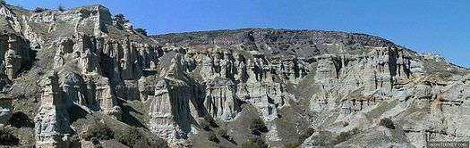
Kula Volcanic Geopark was accepted and certificated by UNESCO on 6 September 2013 at 37th UNESCO general conference in Naples. So that Kula Volcanic Geopark joined UNESCO Global Geopark Network. Also this patent became the first geopark of Turkey, 58th geopark in Europe, and 96th geopark in the world.
See also
- Kula volcano
- Gökçeören, a town in the district
References
Notes
- "Area of regions (including lakes), km²". Regional Statistics Database. Turkish Statistical Institute. 2002. Retrieved 2013-03-05.
- "Population of province/district centers and towns/villages by districts - 2012". Address Based Population Registration System (ABPRS) Database. Turkish Statistical Institute. Retrieved 2013-02-27.
- Turkish Statistical Institute. "Census 2000, Key statistics for urban areas of Turkey" (in Turkish). Archived from the original (XLS) on 2007-07-22. Retrieved 2009-04-05.
- GeoHive. "Statistical information on Turkey's administrative units". Archived from the original on 2008-09-25. Retrieved 2009-04-05.
- Statoids. "Statistical information on districts of Turkey". Retrieved 2009-04-05.
- Prothero, G.W. (1920). Anatolia. London: H.M. Stationery Office. p. 110.
Sources
- Falling Rain Genomics, Inc. "Geographical information on Kula, Turkey". Retrieved 2009-04-04.
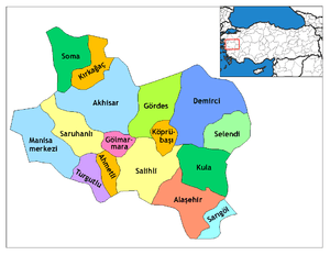
Kula, Manisa in Manisa Province of Turkey | |||||||||||||||||||||||||||
|---|---|---|---|---|---|---|---|---|---|---|---|---|---|---|---|---|---|---|---|---|---|---|---|---|---|---|---|
| Districts | Districts of Manisa | ||||||||||||||||||||||||||
| |||||||||||||||||||||||||||
Metropolitan municipalities are bolded. | |||||||||||||||||||||||||||