Katakekaumene
Katakekaumene or Catacecaumene (Greek: Κατακεκαυμένη) was a name for a district in Lydia (modern western Turkey), and a union of ten cities in the area, during the Hellenistic and Roman periods.
| Katekaumene | |
|---|---|
| Kula[1] | |
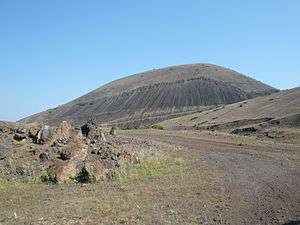 Burnt lands of the Katakekaumene. | |
| Highest point | |
| Elevation | 750 m (2,460 ft) |
| Coordinates | 38°34′38″N 28°31′12″E |
| Geography | |
 Katekaumene | |
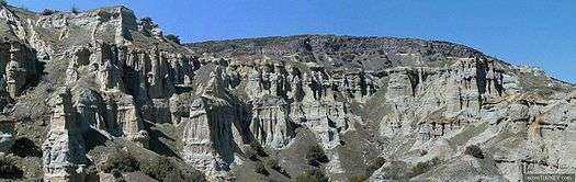
Kula Yanıkyöre rock formations
The name means "burnt land"[2][3] or "burnt country",[4] referring to the pitch-black color of the lava[5] and the dormant volcanic belt of Kula,[6] which was first described by Strabo.[7] Strabo (Geographica, 12.8.19) reported that some place Katakekaumene as the site of the mythological battle between Zeus and the giant Typhon.
Decapolis
Cities of the ancient decapolis included:
- Satala in Lydia
- Maionia in Lydia
- Tabala in Lydia
- Bagis
- Silandos
- Saittae
- Daldis
- Philadelphia in Lydia[8]
- Apollonos-Hieron
- Mesotimolos or Gordos[9]
References
- Patricia Erfurt-Cooper, Volcanic Tourist Destinations (Springer Science & Business Media, 8 August 2012)| pages 100–101.
- Hastings, James, ed. (2004). A Dictionary of the Bible (Part III: O — Pleiades). III. The Minerva Group. p. 830. ISBN 978-1410217271.
- "Turkey's UNESCO-recognized Kula Volcanic Geo-park awaits nature travelers". Daily Sabah. 2 October 2016. Retrieved 25 April 2017.
- Daubner, Frank (26 October 2012). Katakekaumene. The Encyclopedia of Ancient History. doi:10.1002/9781444338386.wbeah14146. ISBN 9781444338386.
- "Earth Sciences – Kula Volcanic UNESCO Global Geopark (Turkey)". UNESCO Global Geoparks. Retrieved 2017-04-08.
- E. Akdeniz. "SOME EVIDENCE ON THE FIRST KNOWN RESIDENTS OF KATAKEKAUMENE (BURNED LANDS)". Mediterranean Archaeology and Archaeometry. 11 (1): 69–74.
- The American Journal of Science, Volume 38 (Kline Geology Laboratory, Yale University., 1840 ) p207.
- Philadelphia in Lydia.
- W. M. Ramsay, The Historical Geography of Asia Minor (Cambridge University Press, 24 Jun. 2010 ) p132.
This article is issued from Wikipedia. The text is licensed under Creative Commons - Attribution - Sharealike. Additional terms may apply for the media files.