Khorramabad
Khorramabad ![]()
Khorramabad خرمآباد | |
|---|---|
City | |
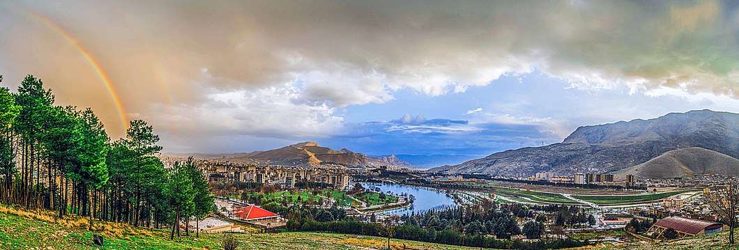
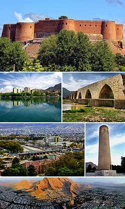 Montage of Khorramabad, Clockwise:Falak-ol-Aflak Castle, Keeyow lake, Shapuri bridge, View of the Khorramabad city, Brick Minaret, Panorama of the Khorramabad | |
Seal | |
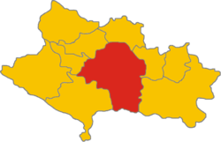 The territory of the Khorramabad inside the province of Lorestan | |
 Khorramabad | |
| Coordinates: 33°29′16″N 48°21′21″E | |
| Country | |
| Province | Lorestan |
| County | Khorramabad |
| Bakhsh | Central |
| Elevation | 1,147 m (3,763 ft) |
| Population (2016 Census) | |
| • Urban | 373,416 [1] |
| Time zone | UTC+3:30 (IRST) |
| • Summer (DST) | UTC+4:30 (IRDT) |
| Climate | Csa |
| Website | www.Khorramabad.ir |
The city population is predominantly Lur and Lak, although the two groups are closely related.[4] Although not a major tourist destination, it is quite scenic and possesses several attractions, such as five Paleolithic cave-dwelling sites.[5] In the city center, a tall citadel called Falak-ol-Aflak (The Heaven of Heavens), a relic of the Sassanid era, is now a nationally popular museum.
Economically, it is the regional base of the agricultural industry.
Etymology
"KhorMoah" is the way local call it. "KhorMoa" in Lori and Laki, local languages, means the place that you can see the sunset.
"KhorMoah" has been translated as "Khorram Abad" in Farsi which means the green and beautiful place.
Modern Persian -âbâd, meaning "settlement" or "abode", derives from Middle Persian āpāt ("populous"). However, according to linguist Sasha Lubotsky, the Persian term ābād might derive from Proto-Iranian *āpāta ("protected"), rooting from Proto-Indo-European *peh₂- ("to protect"). Thus, it can mean "protected settlement".
History
Pre-Islamic era
Simash
During the late third millennium B.C. and early second millennium B.C., when Simashki sovereigns was ruling on Elam, for the first time a fort was built on the peak of a natural cliff to protect the city against its enemies. Sixty hundred years later, Ellipi kings built a new fort on the ruins of the old one. Simash was the name of the place. It was the capital of Simashki dynasty.[6]
Shapurkhast
In the texts of historians Shapurkhast has been considered one of the most important and developed cities of the region during this period. Falak-ol-Aflak castle ( Dež-e Shāpūr-Khwāst) was built by Shapur I the Sasanid.
Islamic era
Probably in the late seventh century CE, Shapurkhast was destroyed and the people of Shapurkhast moved to the western part of Falak-ol-Aflak Castle, which offered plenty of water as well as safety.
Hamdallah Mustawfi writes: Khorramabad was a beautiful city, now it is destroyed.
Hazaraspids
The founder of the Hazaraspid dynasty was Abu Tahir ibn Muhammad, a descendant of the Shabankara chieftain Fadluya. Fadluya was initially a commander of the Salghurids of Fars and was appointed governor of Kuhgiluya[7] but eventually gained independence in Luristan and extended his realm as far as Isfahan. He assumed the prestigious title of atabeg.
Safavid dynasty
During the reign of the Safavid dynasty, Khorramabad was the administrative center of Luristan Province. In the wake of the demise of the Safavids, after the signing of the Treaty of Constantinople (1724) with Imperial Russia, the Ottomans conquered Khorramabad on 6 September 1725.[8]
Qajar dynasty
In this period, the city of Khorramabad was limited to environs of Falak-ol-Aflak Castle. This period was the beginning of a migration of people from small villages into Khorramabad. The increase in population led to the expansion of the city and the creation of new districts.
Pahlavi dynasty
Khorramabad Municipality was formed in 1913 and the first city council, consisting of seven members, was formed in 1916.
Geography
Location
KhorramAbad has mild and semi-humid Mediterranean climate with high amount of rainfall during spring and winter. It is the sixth cities in Iran having high level of annual rainfall. The city is located inside a valley and has been surrounded by mountains. The two main mountains around the city are EsbiKouh (SefidKouh) and Makhmalkouh. The city is rich of underground resources and five main springs passes through it. It has one river called as Gelal or KhorramRud (new name).
Climate
Khorramabad has what is classed under the Köppen climate classification as a Hot-summer Mediterranean climate (Csa) climate. Its elevation is 1147.8 above sea level. Average annual precipitation is 511.06 and its average annual temperature is 17.21 Celsius.
| Climate data for Khorramabad, Iran | |||||||||||||
|---|---|---|---|---|---|---|---|---|---|---|---|---|---|
| Month | Jan | Feb | Mar | Apr | May | Jun | Jul | Aug | Sep | Oct | Nov | Dec | Year |
| Record high °C (°F) | 24.0 (75.2) |
26.0 (78.8) |
31.0 (87.8) |
33.0 (91.4) |
41.0 (105.8) |
43.0 (109.4) |
47.0 (116.6) |
46.0 (114.8) |
43.0 (109.4) |
37.0 (98.6) |
30.0 (86.0) |
24.0 (75.2) |
47.0 (116.6) |
| Average high °C (°F) | 10.5 (50.9) |
12.9 (55.2) |
16.5 (61.7) |
20.7 (69.3) |
27 (81) |
35.5 (95.9) |
39.5 (103.1) |
39.0 (102.2) |
35.3 (95.5) |
28.1 (82.6) |
18.7 (65.7) |
13.4 (56.1) |
25.3 (77.5) |
| Daily mean °C (°F) | 5.0 (41.0) |
7.1 (44.8) |
10.4 (50.7) |
13.8 (56.8) |
18.8 (65.8) |
25.6 (78.1) |
29.6 (85.3) |
28.8 (83.8) |
24.8 (76.6) |
19.0 (66.2) |
12.0 (53.6) |
7.8 (46.0) |
16.9 (62.4) |
| Average low °C (°F) | −0.4 (31.3) |
1.3 (34.3) |
4.3 (39.7) |
7 (45) |
10.6 (51.1) |
15.7 (60.3) |
19.7 (67.5) |
18.7 (65.7) |
14.4 (57.9) |
10.0 (50.0) |
5.4 (41.7) |
2.2 (36.0) |
9.3 (48.7) |
| Record low °C (°F) | −14.6 (5.7) |
−11.0 (12.2) |
−11 (12) |
−2.0 (28.4) |
−1.8 (28.8) |
7.0 (44.6) |
9.2 (48.6) |
8.0 (46.4) |
4.6 (40.3) |
−1.4 (29.5) |
−7.8 (18.0) |
−8.6 (16.5) |
−14.6 (5.7) |
| Average precipitation mm (inches) | 86.0 (3.39) |
73.1 (2.88) |
82.5 (3.25) |
71.6 (2.82) |
36.5 (1.44) |
0.3 (0.01) |
0.1 (0.00) |
0.2 (0.01) |
1.2 (0.05) |
23.5 (0.93) |
54.3 (2.14) |
83.6 (3.29) |
512.9 (20.19) |
| Average rainy days | 11.9 | 10.7 | 12.9 | 11.0 | 6.2 | 0.4 | 0.3 | 0.2 | 0.4 | 4.8 | 7.6 | 10.1 | 76.5 |
| Average snowy days | 2.6 | 1.5 | 0.7 | 0 | 0 | 0 | 0 | 0 | 0 | 0 | 0.1 | 0.9 | 5.8 |
| Average relative humidity (%) | 69 | 64 | 58 | 54 | 43 | 28 | 24 | 25 | 28 | 39 | 55 | 66 | 46.1 |
| Mean monthly sunshine hours | 163.4 | 170.8 | 187.2 | 206.0 | 264.2 | 340.4 | 347.2 | 330.1 | 302.7 | 257.3 | 191.4 | 160.5 | 2,921.2 |
| Source: NOAA (1961-1990) [9] | |||||||||||||
Main sights
ShapurKhast Castle

ShapurKhast Castle, Dež-e Shāpūr-Khwāst, Falak-ol-Aflak Castle, known in ancient times as Dezbaz as well as Shapur-Khast, is one of the most impressive castles in Iran. It is situated on the top of a large hill with the same name within the city of Khorramabad, the regional capital of Lorestan province. The Khorramabad River runs past the eastern and south-western side of the ShapurKhast hill providing the fortress with an element of natural protection. Today, the western and northern sides of the hill are bordered by the residential districts of Khorramabad. This gigantic structure was built during the Sassanid era (226–651). It has been known by a number of names since it was built over 1800 years ago. Recorded names have referred to it as Shapur-Khast fortress, Dezbaz, Khorramabad castle, and ultimately the Falak ol-Aflak Castle. The foundations of the actual castle measure approximately 300 meters by 400 meters. The height of the entire structure, including the hill, reaches up to 40 meters above the surrounding area. This space is divided into four large halls, and their associated rooms and corridors. The rooms all surround two courtyards with the following measurements: the first courtyard measures 31×22.50 meters and the second 29x21 meters. . When originally built the castle used to have 12 towers, but only 8 remain standing today. The building's entrance is situated towards the north, within the body of the north-western tower.
From the initial day of erection the castle served a whole variety of purposes including political, military, governmental and social. Now, Dec. 2019, archaeology and anthropology museums are located inside the castle. Bronzes of Lorestan are among the interesting handmade objects inside the archaeology museum. This scarce monument has been inscribed on the National Heritage List under the registration number of 883.
Gerdaw Bardina
Gerdab Sangi or Gerdaw Bardina is a cylindrical shape monument from Sassanid dynasty (224-651 CE) located in Takhti Square. The main construction materials are lime-mortar and rocks exploited from SefidKouh mountain. Encircling several springs, the edifice sits near the prehistoric Qamari Cave. The construction was once used for rationing and distributing potable and agricultural water among local population and farmers. Its surrounding cylindrical stone wall has a height of 10 meters and a diameter of 18 meters. There are a few different-sized outlets in the wall for controlling the flow of water into a canal on the west of the structure. While originally there were 7 of such outlets, however, today only one is functional. This outlet measures 160 x 90 centimeters and opens and closes like a drawer. There is traces of another outlet which the water was flowing from it and was reaching to a stream called Nahre Naseri. The flowing water after a path of approximately 12 kilometers, would eventually made its way to a valley called Baba Abbas. The main interesting thing is the way that they have conducted the water to the stream. Gerdab Sangi has been inscribed on the National Heritage List in 1976.
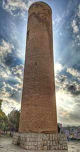
Brick minaret
Brick Minaret is a cylindrical brick tower from Seljuq and Buyid dynasties located inside the ancient city of Shapur khast, south of Khorramabad.
ُThe Iranian minaret are combination of the Indian Stupa, commemorative columns, central Asia tradition of tower building for defensive and communication purposes.[10] Brick Minaret of KhorramAbad was probably used as a guidepost for caravans that pass the city, i.e. communication purpose.
The current height of minaret is 29.45 meters. Since one of the windows of the minaret is located on top of it, undoubtedly its height was higher. A cylindrical column was built inside the minaret and through 99 spiral staircases around the column one can reach to the top of the minaret. The entrance is opened to the west and its characteristics are as follows: length: 80 cm, height: 220 cm. The minaret has six windows of different sizes. The windows spread the light into the dark corridor. Brick and mortar are its main construction material.
This monument has been inscribed on the national heritage list under registration number 1930.
Sang Nebeshteh
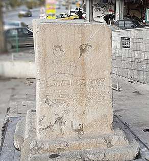
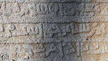
Sang Nebeshteh (inscribed stone) is an engraved cubic shape monument with 3.54 m heights located at the eastern part of KhorramAbad city. It dates back to 1119 AD and Saljuq dynasty. It has been written in Kufic script and its subject is governmental rules of ShapurKhast, which is currently known as KhorramAbad city. The carved name of ShapurKhast city can be clearly seen on this monument. This name verifies the existence of ShapurKhast city during old days. It has been inscribed on the national heritage list.
Pole Gap (Gap Bridge)
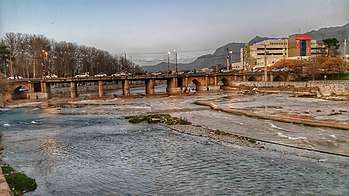
Pole Gap is a Safavid multi-arch bridge passing through KhorramAbad city and located near to ShapurKhast castle. Its twenty arches except its breakwaters and piles are made from bricks and mortar. The height of bridge is about 18 meters. Some of its arches are in the underground of the shops in two sides of the bridge. The bridge is very similar to Si-o-se-pol at Isfahan. About fifty years ago, an inscription has been found inside one of the ruined arches. The inscription has two meters length and 85 centimeters height. Probably, it has been written to protect the bridge form evil eyes and natural phenomena.
Sahpuri Bridge (Tage Pil Eshkesa)
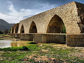
Shapuri bridge has been constructed on KhorramAbad river (Gelal river) by the order of Shapur I during Sassanian period. It was built in the historic rout between Shapurkhast, Tarhan and Ctesiphon, the capital of Sassanian. Lorestan has more than 70 historical bridges and form this perspective is considered as the capital of ancient Iranian bridges.
Shapuri bridge has 312 meters length and elongated in the east-west direction. Some scholars believe that this bridge was the first gigantic bridge in Lorestan province and other bridges in the province has been built by inspiring from it. It has 28 arches and 27 piles, with surface are of 61 square meters. Currently, five of its arches are intact; the others have been destroyed by natural phenomena. The arches of the bridge are made in the form of a wishbone. The piles and breakwaters of the bridge are in the form of six lateral lozenges made of limestone. Probably the bridge also was used to distribute water. Materials of the bridge are river stones and stone chips in the arches and truncated stones in the piles. The bridge floor is paved in red block stones that have lost their square shape due to erosion. This attractive, huge bridge from Sassanid dynasty has been inscribed in the national heritage list under registration number 1058.
AkhoundAbu House
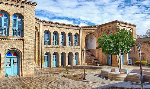
Akhound Abu House is located in the historical texture of KhorramAbad city near to BabaTaher neighborhood and ShapurKhast castle.
It belonged to Mirza Mohsen Gazi, who was chief justice of the city during late Qajar and early Pahlavi dynasties.
The house is semi-introverted and is divided to winter and summer sections. The first one which is used during winter has two important rooms: Panjdari and Sedari. Panjdari is also called Shahneshin and was the most attractive room of the house. Muqarnas, Zigzag bricks (Khefteh-Rasteh), Golandaz are the main decoration of the house. The construction materials of the house are stone, brick, wood and mortar.
Currently, museum of Lorestan's handicrafts is located inside the house. Tickets to visit this house are free. This monument has been inscribed on the national heritage list under registration number 2432.
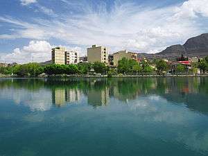
Keeyow lake
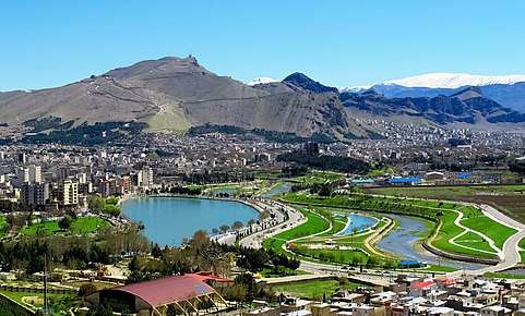
Keeyow lake is a natural lake located in the Northwest of Khorramabad city. In 1975, It has been constructed by the order of Ali Mohammad Saki, the late mayor of KhorramAbad. This lake spans a seven-hectare area and has a depth of 3 to 7 meters. It is the sole natural lake in Iran which is located inside a city. The lake is an appropriate place for aquatic animals, native and migratory birds. The amusement park as well as other recreational facilities next to the lake enhances its aesthetic and geotouristic values . The main spring of the lake is located in the northern part of the lake and is supplied by aquifers from nearby mountains.[11] Since the spring is a seasonal one, during winter the water is supplied from another permanent spring located under ShapurKhast castle, Golestan spring.
During holidays many tourists and locals spend their leisure time in the amusement park or use other facilities inside a park located near to the lake, Keeyow Park. It is the most important park of the city. Everyday morning, many locals come to use the sporting facilities and/or do the hiking and running around the lake.
Colleges and universities

- Islamic Azad University of Khorram Abad
- Lorestan University[12]
- Lorestan University of Medical Sciences[13]
- Madanni Technical College[14]
Sister cities and twin towns
| Country | City | State / Province / Region / Governorate | Date | |||
|---|---|---|---|---|---|---|
| Turkey | Afyonkarahisar | Afyonkarahisar Province | 2015[15] | |||
| Japan | Yamagata | Yamagata Prefecture | October 2013[16] | |||
Photo gallery
 Nojian oak forest Khorramabad county
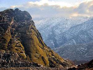 Makhmalkuh Khorramabad county
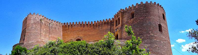
 Keeyow lake Khorramabad
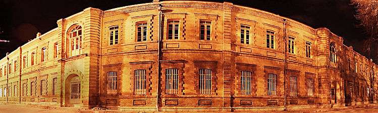 Sarbazkhane building - khorramabad
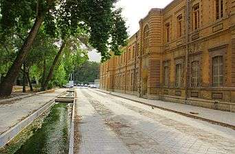 Building in Khorram abad
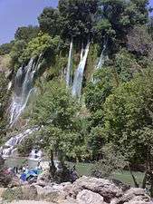 Bisheh waterfall Khorramabad county
 Khorramabad city Khorramabad county
See also
References
- https://www.amar.org.ir/english
- Khorramabad can be found at GEOnet Names Server, at this link, by opening the Advanced Search box, entering "-3071194" in the "Unique Feature Id" form, and clicking on "Search Database".
- "Census of the Islamic Republic of Iran, 1385 (2006)". Islamic Republic of Iran. Archived from the original (Excel) on 2011-11-11.
- Anonby, Erik John "Update on Luri: How many languages" JRAS (Journal of the Royal Asiatic Society) Series 3 13(2): pp. 171–197, p.183, doi:10.1017/S1356186303003067
- Baumler, Mark F. and Speth, John D. (1993) "A Middle Paleolithic Assemblage from Kunji Cave, Iran" pp. 1–74 In Olszewski, Deborah and Dibble, Harold Lewis (editors) (1993) The Paleolithic prehistory of the Zagros-Taurus The University Museum of Archaeology and Anthropology, University of Pennsylvania, Philadelphia, Pennsylvania, ISBN 978-0-924171-24-6
- بهرامي، سبزی، توسلی (2017). "مکانیابي جای نام سیماش شاهک نشین الیپي در خرم آباد و امکان یکي دانستن آن با سیماشکي عیلامي". مطالعات باستان شناسی: 30.
- B. Spuller,Atabakan-e Lorestan, Encyclopædia Iranica.
- Somel, Selcuk Aksin (2003). Historical Dictionary of the Ottoman Empire. Scarecrow Press. p. xlvi. ISBN 978-0810866065.
- "Khoram Abad Climate Normals 1961-1990". National Oceanic and Atmospheric Administration. Retrieved December 28, 2012.
- Hutt, Anthony Max. (1974). The development of the Minaret in Iran under the Saljügs. A thesis presented for the degree of M. Phil. at London University. OCLC 46455166.
- "دریاچه کیو خرمآباد تنها دریاچه طبیعی درونشهری ایران". Young Jouranalists Club. Retrieved 29 October 2017.
- Lorestan University" homepage, in English Archived September 20, 2010, at the Wayback Machine
- "Lorestan University of Medical Sciences homepage". Lums.ac.ir. Retrieved 2012-09-12.
- "afpkh.ir". afpkh.ir. Archived from the original on 2012-09-11. Retrieved 2012-09-12.
- "Archived copy". Archived from the original on 2015-04-02. Retrieved 2015-03-02.CS1 maint: archived copy as title (link)
- "راهنمای ثبت شرکت در خرم آباد". www.Sabt-ag.ir.
External links

- Khorramabad municipality
| Capital |  | ||||||||||||||||||||||
|---|---|---|---|---|---|---|---|---|---|---|---|---|---|---|---|---|---|---|---|---|---|---|---|
| Counties and cities |
| ||||||||||||||||||||||
| Sights |
| ||||||||||||||||||||||
| populated places | |||||||||||||||||||||||
| Capital | |||||||||||||||||||||||||||||||||||||||||||||||||||||||||||
|---|---|---|---|---|---|---|---|---|---|---|---|---|---|---|---|---|---|---|---|---|---|---|---|---|---|---|---|---|---|---|---|---|---|---|---|---|---|---|---|---|---|---|---|---|---|---|---|---|---|---|---|---|---|---|---|---|---|---|---|
| Districts |
| ||||||||||||||||||||||||||||||||||||||||||||||||||||||||||
| Styles |
|  | ||||||
|---|---|---|---|---|---|---|---|---|
| Types | ||||||||
| Elements | ||||||||
| Traditional cities | ||||||||
| Theory and analysis | ||||||||
| Lists |
| |||||||