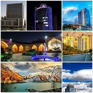
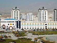
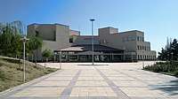
Karaj
Karaj (Persian: کرج, pronounced [kæˈɾædʒ] (![]()
Karaj کرج | |
|---|---|
City | |
 | |
Seal | |
 Karaj | |
| Coordinates: 35°50′08″N 51°00′37″E | |
| Country | |
| Province | Alborz |
| County | Karaj |
| Bakhsh | Central |
| Government | |
| • Mayor | Ali Asghar Kamalizadeh |
| • City Council Chairman | Abbas Zare |
| Area | |
| • City | 162 km2 (63 sq mi) |
| Elevation | 1,312 m (4,304 ft) |
| Population (2016 Census) | |
| • Urban | 1,592,492 [1] |
| • Metro | 2,512,737 [2] |
| • Population Rank in Iran | 4th |
| Time zone | UTC+3:30 (IRST) |
| • Summer (DST) | UTC+4:30 (IRDT) |
| Area code(s) | 026 |
| Climate | BSk |
| Website | karaj.ir |
The earliest records of Karaj date back to 30th century BC. The city was developed under the rule of the Safavid and Qajar dynasties, and is home to historical buildings and memorials from those eras. Until the second half of the 20th century, it used to be known mainly as a summer resort. Today, it is a major industrial city, with factories producing sugar, textiles, wire, and alcohol.
History
Karaj has been hosting communities since 3000 years BC.[4][5] The Khurvin region of Karaj has been inhabited since the Bronze Age, and the Kelak region on the left bank of Karaj River since the Iron Age.
The stone built Takht-e Rostam, located on a mount in the west of Shahriar County, was built in the Parthian era as a Zoroastrian fire temple.
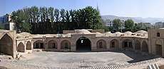
Until the late 20th century, the city was mainly crossed into by a stone bridge built in the Safavid era. The stone built Shah-Abbasi Caravansary, located at the southeast of Towhid Square, was built in the same era, under the rule of Šāh Esmāil.[5]
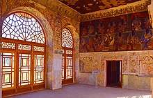
In the 1810s, the Palace of Soleymaniye, which included four towers surrounded by gardens and walls, was built as a summer resort by the order of Shahzaden Soleyman (Soleyman Mirza), an old prince governor of Kermānšāh.[5] Granted in the Pahlavi era by Rezā Šāh Pahlavi, it is now housing the Faculty of Agriculture of the University of Tehran.
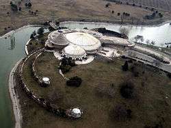
The Morvārid Palace was constructed in nearby Mehršahr district, during the Pahlavi era. It was designed by the Frank Lloyd Wright Foundation (Taliesin Associated Architects) on instructions from Shams Pahlavi, elder sister of Mohammad Reza Pahlavi. Majority of the structure is now controlled by the Basij Organization, and some sections of it are open to public under the operation of Cultural Heritage Organization of Iran.
Other historical sites of the city include the Mausoleum of Šāhzāde Soleymān, Emāmzāde Rahmān, Emāmzāde Zeyd, and Palang Ābād e Eštehārd.[6]
Geography

Karaj is situated 20 kilometres (12 mi) west of Tehran, at the foothills of the Alborz mountains.
Built on a wide plain with some gentle hills, the city is located north of the agricultural plain of Šahriār and east of the plains of Sāvoj Bolāq and Haštgerd.
Regions

The downtown of Karaj is usually referred to Karaj Square, located hundred of meters to the west of Karaj River and the old Karaj Bridge. The villages Hesārak, Gowhar Dašt, and Šahrak e Azimie are located in the northern Greater Karaj. Mehršahr, an abortive residential luxury resort, and Šahrak e Fardis, a popular modern quarter close to the industrial facilities,[7] were designed by the Frank Lloyd Wright Foundation in the late 1960s.
Meškin Dašt, a large agricultural area between Mehršahr and Fardis, lies outside the municipal limits of Karaj.
The following table includes the major districts of the city:
| Gouhar Daŝt | Mehrŝahr | Kiānmehr | Karaj e Now | Hesārak | Deraxti | Azimie | Ouj | Ŝāhin Villā | Bonyād | Bāqestān | Doulat Ābād |
| Garm Darre | Ŝahrake Jahānŝahr | Mesbāh | Mehr Villā | Dehqān Villā | Māhdaŝt | Ŝahrake Banafŝe | Fardis | Vahdat | Kalāk o Hesār | Estām Ābād | Golŝahr |
| Golŝahr Villā | Zibā Daŝt | Zoube Āhan | Sāsāni | Homāyun Villā | Mehrānŝahr | Mehdi Ābād | Ŝahrake Xātam | Miān Jādde | Heydar Ābād | Sāwoj Bolāq | Bahārestān |
Open space recreational areas of Karaj include Irānzamin Park, Pārk e Xānvāde, Tennis Park, Pārk e Mādar, Tāleqān Gardens, Kordān Gardens, Jahānšahr Gardens, Pardis e Golhā, and the Tulip Garden of Gačsār.
Climate
The climate of Karaj is a bit cooler than Tehran's, and it receives 260 mm of rain annually (and like Tehran, the precipitation pattern is similar to those of Mediterranean climates). The Köppen-Geiger climate classification system classifies the city's climate as cold semi-arid (BSk).[8]
| Climate data for Karaj (1985–2010) | |||||||||||||
|---|---|---|---|---|---|---|---|---|---|---|---|---|---|
| Month | Jan | Feb | Mar | Apr | May | Jun | Jul | Aug | Sep | Oct | Nov | Dec | Year |
| Record high °C (°F) | 18.2 (64.8) |
19.8 (67.6) |
27.4 (81.3) |
33.0 (91.4) |
34.6 (94.3) |
39.2 (102.6) |
42.0 (107.6) |
40.2 (104.4) |
37.2 (99.0) |
31.8 (89.2) |
25.0 (77.0) |
20.0 (68.0) |
42.0 (107.6) |
| Average high °C (°F) | 6.1 (43.0) |
9.0 (48.2) |
14.2 (57.6) |
20.7 (69.3) |
26.2 (79.2) |
32.6 (90.7) |
35.2 (95.4) |
34.5 (94.1) |
30.4 (86.7) |
23.5 (74.3) |
15.1 (59.2) |
8.9 (48.0) |
21.4 (70.5) |
| Daily mean °C (°F) | 1.8 (35.2) |
4.1 (39.4) |
8.7 (47.7) |
14.5 (58.1) |
19.2 (66.6) |
24.6 (76.3) |
27.1 (80.8) |
26.8 (80.2) |
22.9 (73.2) |
17.1 (62.8) |
9.9 (49.8) |
4.6 (40.3) |
15.1 (59.2) |
| Average low °C (°F) | −2.5 (27.5) |
−0.7 (30.7) |
3.2 (37.8) |
8.4 (47.1) |
12.2 (54.0) |
16.5 (61.7) |
19.0 (66.2) |
19.1 (66.4) |
15.3 (59.5) |
10.8 (51.4) |
4.8 (40.6) |
0.3 (32.5) |
8.9 (48.0) |
| Record low °C (°F) | −17.0 (1.4) |
−15.6 (3.9) |
−10.5 (13.1) |
−3.5 (25.7) |
−0.4 (31.3) |
7.2 (45.0) |
10.6 (51.1) |
12.0 (53.6) |
7.0 (44.6) |
−0.5 (31.1) |
−6.0 (21.2) |
−14.6 (5.7) |
−17.0 (1.4) |
| Average precipitation mm (inches) | 30.8 (1.21) |
32.1 (1.26) |
45.4 (1.79) |
39.1 (1.54) |
19.5 (0.77) |
2.7 (0.11) |
3.0 (0.12) |
1.2 (0.05) |
1.6 (0.06) |
15.1 (0.59) |
27.7 (1.09) |
33.5 (1.32) |
251.7 (9.91) |
| Average precipitation days (≥ 1.0 mm) | 6.3 | 5.7 | 6.7 | 5.8 | 3.7 | 1.0 | 0.7 | 0.3 | 0.3 | 3.2 | 4.8 | 5.8 | 44.3 |
| Average snowy days | 5.4 | 3.7 | 1.9 | 0.1 | 0.0 | 0.0 | 0.0 | 0.0 | 0.0 | 0.0 | 0.5 | 2.7 | 14.3 |
| Average relative humidity (%) | 67 | 60 | 53 | 48 | 43 | 34 | 35 | 34 | 36 | 44 | 56 | 66 | 48 |
| Mean monthly sunshine hours | 166.3 | 169.7 | 197.4 | 218.1 | 280.7 | 335.2 | 341.5 | 340.1 | 304.2 | 250.1 | 187.2 | 156.8 | 2,947.3 |
| Source: Iran Meteorological Organization (records),[9] (temperatures),[10] (precipitation),[11] (humidity),[12] (days with precipitation and snow),[13] (sunshine)[14] | |||||||||||||
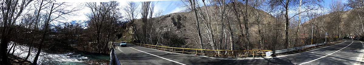
Amir Kabir Dam and some other small lakes are based in Karaj. The city is a starting point for a drive along road forced north through the Alborz mountain to the Caspian Sea.[15]
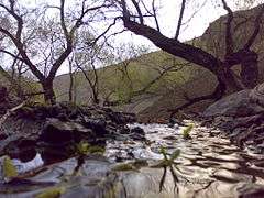 Karaj Valley
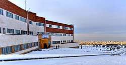
 Karaj in winter
 Karaj Dam
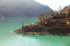 Another view of the Karaj Dam
Demographics
The majority of the residents of Karaj are Persian-speaking people, with Azerbaijanis making up the second major ethno-linguistic group of the city. Kurds, Gilak, Tabari and Lurs include the other ethnicities among the population of Karaj.
| Male | Female | Total | Ref. |
|---|---|---|---|
| 890,824 | 886,570 | 1,759,394 | [17] |
| age (0–14 years) | age (15–29 years) | age (30–64 years) | age (65 and more years) |
|---|---|---|---|
| 20.3% | 23.6% | 50.2% | 6.0% |
Transport
Railway
Karaj is connected by railway and highways to Tehran 40 km east and Qazvin 100 km northwest, and by commuter rail to the subway system of Tehran.
The city is served by an urban railway organization established on 21 December 2001.[18][19] It is also served by the Karaj Metro Station which was established on 7 March 1999, and is located in the south-eastern Karaj, near Tehran–Qazvin Freeway.
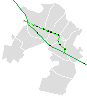
| Line | Line Route | Length | Stations |
|---|---|---|---|
| 1 | گرمدره – گلشهر – پایانه مهرشهر | 17 km (10.5 mi) | 4 |
| 2 | کمالشهر – چهارراه طالقانی – میدان امام حسین – شهر ملارد | 27 km (16 mi) | 23 |
| 3 | ایستگاه کرج (میدان شهید سلطانی) – عظیمیه – بلوار موذن – باغستان | 14 km (9 mi) | 12 |
| 4 | باغستان – فرودگاه پیام | 18 km (11.1 mi) | 19 |
| 5 | بلوار شهید موذن (دانشگاه آزاد اسلامی) – محمد شهر | 12 km (7.5 mi) | 10 |
| 6 | بلوار تربیت مربی – میدان شهید سلطانی | 9 km(6 mi) | 8 |
| Total: | 97 km (60 mi) | 76 | |
Road
The highway system of Karaj includes Tehran–Karaj Highway, Karaj Special Road, and the old road of Karaj (Fath Highway). Bākeri Expressway is one of the main north-to-south routes in west Tehran, which is connected to the Tehran–Karaj Highway.[20] Tehran–Karaj Highway is one of the busiest sections in Iran with AADT of 217084.[21] Karaj–Qazvin has an AADT of 79606.
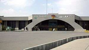
The aerial transport of Karaj is served by the Payam International Airport, which was established in 1990, and was officially opened in 1997.
Bus
Currently, the total number of buses in Karaj and the suburbs are 1,600 units. More than 80 lines serve citizens.[22]
Preparing Alborz Card[23] can reduce the cost of travel tickets.
Metro
Karaj Metro is an efficient way to travel inside the city. One line connects west and east of the city (from Karaj Station to Golshahr Station). It continues eastward until Tehran. On its way to Tehran, it stops at Chitgar park and Azadi stadium. The second line of Karaj metro (north to south) is under construction.
Air
Payam International Airport, is an international airport located in Karaj, 40 kilometres (25 mi) from Tehran, in the Alborz Province of Iran. The airport was established in 1990, but was not opened officially until 1997. Payam Aviation Services Co. operates the airport as part of Payam Special Economic Zone. Payam Air previously operated an air mail hub at the airport.
Economy
The economic base of Karaj is its proximity to Tehran. It is due to the transportation of products between Tehran and the Caspian Sea. Chemicals, fertilizers and processed agricultural goods are also produced in the city.
Karaj is a major industrial city, with factories producing sugar, textiles, wire, and alcohol. It has become a major area for middle class migrants from Tehran. This is due to the better environmental and cheaper housing conditions.
Zowb Āhan, the avenue leading to an industrial plant, is located at the south of Ostandar Square. Zowb e Āhan or Zowb Āhan, literally "steel mill", was a contract between the Pahlavi government and a consortium from Nazi Germany. The establishment of the factory Zowb Āhan e Karaj was halted by the beginning of the Second World War, and it was never launched.
Šahrak e Jahānšahr was the first modern private industrial and housing complex of Karaj, built in the 1960s. The factories Jahān Čit (textile factory), Rowqan Nabāti e Jahān (oil factory), and Čāy e Jahān (tea factory), were established at the complex. It is one of the largest industrial zones of the nation, with a 20% share of the national GDP [citation?].
The special economic zone of Payam, with an area about 3600 hectares within the territory of Payam International Airport, was established in Karaj for development of air cargo and postal transportation, cold store, and packing services, as well as perishable and time sensitive exports. It is the only SEZ in the region with the privilege of its own airline.
Tourist Attractions
Historical
| Place name | Longevity |
| Gachsar Iron Road and Stone Bridge | Islamic era |
| Imamzadeh Ahmad and Mahmoud | Islamic era |
| Heljerd Mosque | Qajar |
| Karaj Central Mosque | Qajar |
| Kandovan Caravanserai | Qajar |
| Shah Abbasi Caravanserai | Safavids |
| Old Cemetery | Safavids |
| Plane trees Hesar | 800 years |
| Cypress | 1300 years |
| Agh Tapeh | Ancient |
| Mahdasht historical hill | 3rd millennium BC |
| Yakh Morad Cave | Ancient |
| Heydar Abad Bath | Safavids |
| Suleymanieh Palace | Qajar |
| Mesbah Historical Bath | Qajar |
| Pearl Palace | Pahlavi |
Recreational
- Dizin
- Amir Kabir Dam
- Karaj River
- Karaj Baam
- Khor Ski Resort
- Baraghan Rural District
- Asara
- Atashgah, Alborz
- Varian
- Fateh Garden
- Pars Aqua Village
- Apple Garden of Mehrshahr
- Aghasht
- Arangeh
- Jahanshahr
Education
Educational and research centers of the city include:
- Islamic Azad University of Karaj
- Kharazmi University
- Alborz university of medical sciences
- Faculty of Music of the Tehran University of Art
- Faculty of Architecture and Urbanism of the Tehran University of Art
- Faculty of Agriculture and Natural Resources of the University of Tehran
- University of Environment
- Payam e Noor University of Karaj
- Razi Vaccine and Serum Research Institute
- Center for Research in Agriculture and Nuclear Medicine of Karaj
- Material and Energy Research Center
- Karaj University of Art
- Karaj Payam Noor University
Sports
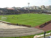
Karaj was formerly home of the Persian Gulf Pro League club, Saipa, for several years and this club won its first league championship in this city, however in 2014 the team relocated to Tehran. Currently the only professional football team in city is Oxin Alborz that play in the Azadegan League. The Home stadium of Oxin Alborz F.C. is Enghelab Stadium that located in Karaj Enghelab sport complex and has a capacity of 15,000 people. Saipa volleyball team lost to Kalleh team in this stadium in 2011–12 and became the runner-up in the final match of the country's volleyball premier league.
Karaj also has an international tennis complex which is used to training and tournaments.
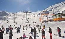
One of the international ski resorts of Iran The, Dizin ski resort, is located a few kilometers north-east of the city, in the Alborz. In Dizin, along with skiing facilities, there are tennis courtyards, a slope for skiing on turf, some altitudes for mountain climbing and walking as well as riding and some routes for cycling.[24]
Notable people

Academia and scholars
- Saied Reza Ameli (b. 1961), a scholar of communication
- Seyed Mahdi Alavi (b. 2003), The youngest genius of mathematics and robotics, the smallest recoup teacher at Sharif University of Technology
Actors
- Mehran Rajabi (b. 1962), actor
- Mehraneh Mahin Torabi (b. 1957), actress
Politicians and political activists
- Fatemeh Ajorlou (b. 1966), politician
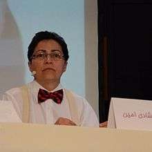
- Shadi Amin, political activist, researcher
- Mahmoud Bahmani (b. 1947), politician
Writers
- Hossein Sanapour (b. 1960), writer
- Saeed Kamali Dehghan (b. 1985), journalist
- Fateme Ekhtesari (b. 1986), poet
Athletes
- Ahmad Sanjari (b. 1960), football coach
- Farshad Falahatzadeh (b. 1967), football player
- Mojtaba Taghavi (b. 1968), football player
- Leila Esfandyari (1970–2011), mountain climber
- Alireza Heidari (b. 1976), Olympic wrestler
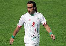
- Ali Karimi (b. 1978), football player
- Ebrahim Sadeghi (b. 1979), football player
- Mohammad Nosrati (b. 1981), football player
- Rouhollah Dadashi (1982–2011), powerlifter
- Ebrahim Masoudi (b. 1982), futsal player
- Mehdi Mahdavi (b. 1984), volleyball player
- Ali Mohammadi (b. 1984), wrestler
- Afshin Kazemi (b. 1986), futsal player
- Amin Manouchehri (b. 1986), football player
- Reza Mohammadi (b. 1986), football player
- Ali Kiaei (b. 1987), futsal player
- Mehrdad Pooladi (b. 1987), football player
- Milad Farahani (b. 1988), football player
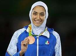
- Kimia Alizade (b. 1998), Iranian first female and youngest Olympic medalist
See also
- Morvārid Palace
- Mehršahr
- Amir Kabir Dam
References
- https://www.amar.org.ir/english
- City Population: IRAN: Major Cities
- L. van den Berghe, La nécropole de Khūrvīn, Istanbul, Nederlands Historisch-Archaeologisch Instituut in het Nabije Oosten, 1964.
- Karaj i. Modern City
- Itto: Karaj
- Frank Lloyd Wright Foundation's deteriorating masterpiece in Iran, Nima Kasraie - June 4, 2004
- "Climate: Karaj - Climate graph, Temperature graph, Climate table". Climate-Data.org. Retrieved 9 September 2013.
-
- "Highest record temperature in Karaj by Month 1985–2010". Iran Meteorological Organization. Archived from the original on April 14, 2015. Retrieved April 7, 2015.
- "Lowest record temperature in Karaj by Month 1985–2010". Iran Meteorological Organization. Archived from the original on April 14, 2015. Retrieved April 7, 2015.
-
- "Average Maximum temperature in Karaj by Month 1985–2010". Iran Meteorological Organization. Archived from the original on April 14, 2015. Retrieved April 7, 2015.
- "Average Mean Daily temperature in Karaj by Month 1985–2010". Iran Meteorological Organization. Archived from the original on April 14, 2015. Retrieved April 7, 2015.
- "Average Minimum temperature in Karaj by Month 1985–2010". Iran Meteorological Organization. Archived from the original on April 14, 2015. Retrieved April 7, 2015.
-
- "Monthly Total Precipitation in Karaj by Month 1985–2010". Iran Meteorological Organization. Archived from the original on March 30, 2015. Retrieved April 7, 2015.
-
- "Average relative humidity in Karaj by Month 1985–2010". Iran Meteorological Organization. Archived from the original on April 14, 2015. Retrieved April 7, 2015.
-
- "No. Of days with precipitation equal to or greater than 1 mm in Karaj by Month 1985–2010". Iran Meteorological Organization. Archived from the original on April 14, 2015. Retrieved April 7, 2015.
- "No. of days with snow or sleet in Karaj by Month 1985–2010". Iran Meteorological Organization. Archived from the original on April 14, 2015. Retrieved April 7, 2015.
-
- "Monthly total sunshine hours in Karaj by Month 1985–2010". Iran Meteorological Organization. Archived from the original on April 14, 2015. Retrieved April 7, 2015.
- Iran. Ediz. Inglese by Andrew Burke, Mark Elliott, and Kamin Mohammadi, 2004
- "Pars". Pars. Archived from the original on 2016-02-17. Retrieved 2016-02-12.
- "درگاه ملی آمار". www.amar.org.ir. Archived from the original on 2019-09-06. Retrieved 2019-06-26.
- "Karaj Urban Railway History". Archived from the original on 2016-03-04. Retrieved 2015-05-27.
- Iran Railways Map
- Main Bridges on Tehran-Karaj Highway Commissioned
- تردد بیش از یک میلیون خودرو از آزادراه تهران -کرج Archived 2013-08-12 at the Wayback Machine
- "کرج - ویکیسفر". fa.wikivoyage.org (in Persian). Retrieved 2019-06-26.
- "Alborz Card - E-pay for transportation".
- "ITTO: Dizin Ski Slope". Archived from the original on 2012-03-07. Retrieved 2010-12-14.
External links
| Wikivoyage has a travel guide for Karaj. |
| Wikimedia Commons has media related to Karaj. |
- Karaj city portal (in Persian)
- About Karaj city (in Persian)
- Karaj News & Information (in Persian)
- The city of Karaj
- Iran Tourism & Touring Organization
- Karaj Magazine (in Persian)
- Karaj Background History (in Persian)
| Capital | 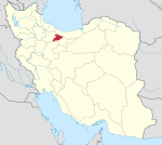 | ||||||||||||
|---|---|---|---|---|---|---|---|---|---|---|---|---|---|
| Counties and cities |
| ||||||||||||
| Sights |
| ||||||||||||
| populated places | |||||||||||||
| Capital | |||||||||||||||||||||||||
|---|---|---|---|---|---|---|---|---|---|---|---|---|---|---|---|---|---|---|---|---|---|---|---|---|---|
| Districts |
| ||||||||||||||||||||||||
| Authority control |
|---|