Khmelnytskyi, Ukraine
Khmelnytskyi (Ukrainian: Хмельни́цький, romanized: Chmeľnyćkyj, pronounced [xmelʲˈnɪtsʲkɪj];[lower-alpha 1] Polish: Chmielnicki), until 1954 Proskuriv (Ukrainian: Проску́рів [proˈskur⁽ʲ⁾iu̯]; Polish: Płoskirów), is a city in western Ukraine, the administrative center for the Khmelnytskyi Oblast (region) and the Khmelnytskyi Raion (district). Khmelnytskyi is located in the historic region of Podolia on the banks of the Buh River. The city received its current local government designation in 1941.
Khmelnytskyi Хмельницький | |
|---|---|
%2C_%D0%A5%D0%BC%D0%B5%D0%BB%D1%8C%D0%BD%D0%B8%D1%86%D1%8C%D0%BA%D0%B8%D0%B9_%D0%B2%D1%83%D0%BB._%D0%9F%D1%80%D0%BE%D1%81%D0%BA%D1%83%D1%80%D1%96%D0%B2%D1%81%D1%8C%D0%BA%D0%B0%2C_47.JPG) 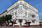  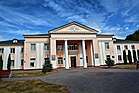  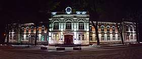 | |
 Flag  Coat of arms | |
 Khmelnytskyi Location of Khmelnytskyi in Ukraine  Khmelnytskyi Khmelnytskyi (Ukraine) | |
| Coordinates: 49°25′0″N 27°00′0″E | |
| Country | |
| Oblast | |
| City council | |
| First mentioned | 1431 |
| City rights | September 22, 1937 |
| Government | |
| • Mayor | Oleksandr Symshyshyn |
| Area | |
| • Total | 90 km2 (30 sq mi) |
| Population (2005) | |
| • Total | 290,100 |
| • Density | 2,822/km2 (7,310/sq mi) |
| Postal code | 29000 |
| Area code(s) | +380 382 |
| Website | http://www.khmelnytsky.com |
In 2015, the city's population was 267,973, making it the second largest city of the former, archaic Podolia region after Vinnytsia and the largest city of the western part of the region.
History
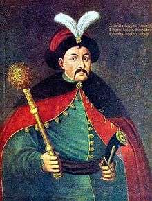
The city foundation date is uncertain. The territory, where Khmelnytskyi is situated, has been inhabited for a very long time. Many archaeological discoveries have been discovered in the city suburbs. For example, to the East of Lezneve district, there was a settlement from the Bronze Age 2000 B.C., and from Scythian times from 7–3 century B.C.[1] The first mention of the city was written with Cyrillic alphabet. From 1431 it was known as Płoskirów (Ploskirov, Плоскиров) and was part of the Kingdom of Poland. It was a royal city. Polish rule was briefly interrupted by Ottoman one between 1672 and 1699. During this period, it was nahiya centre in Mejibuji sanjak in Podolia Eyalet as Poloskiruf.[2] After the Second Partition of Poland in 1793, the city was annexed by the Russian Empire and was renamed Proskurov (Проскурoв). According to the Russian census of 1897, Proskurov with a population of 22,855 was the fifth largest city of Podolia after Kamianets-Podilskyi, Uman, Vinnytsia and Balta. In 1920 it became part of Soviet Ukraine. In 1954 the city was finally renamed Khmelnytskyi (Хмельницький) in the honor of the 300th anniversary of a treaty negotiated by Bohdan Khmelnytsky.
Pogroms
A series of Jewish pogroms have been carried out in the region, known together as the Proskurov pogrom. According to Vinnytsia's city archives the pogrom was conducted on the Friday night of February 15, 1919 by one of the otamans (generals) of the Ukrainian People's Army, Otaman Semysenko (also rendered as Semesenko). In total 390 men, 309 women and 76 children were killed, and 500 individuals were wounded.
The Chief Otaman Petliura had been appointed head of state just two days prior to the tragedy, on February the 13th. Petliura issued Order 131 in which he mentioned the fact that numerous Jewish parties in Ukraine (Bund, Poale Zion, Folks-Partei, Unificationists) rose to defend the sovereignty of the Ukrainian Republic and were cooperating with the Ukrainian government. He condemned such pogroms, calling those initiating them deserters and enemies of the State that must be liquidated. The order was co-signed by the Chief of Staff, Otaman Yunakiv. The order was published in the Ukraina newspaper on February 20 (March 4, old style). Later, Petliura issued a special order to execute Semysenko for being the pogrom initiator. According to sources the order was carried out[3] on March 20, 1920. Other sources claim that he was released.[3]
During the Schwartzbard trial, at the end of which Petliura's assassin was pardoned on the grounds of self-trail (revenge), the main argument of the defense was that Schwartzbard had acted as an avenger of the Jews killed in pogroms perpetrated during Petliura's rule.
World War II
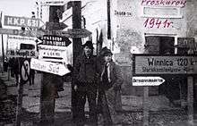
The town was occupied by the German Army from July 8, 1941 to March 25, 1944. On November 4, 1941, 5300 Jewish inhabitants of the town and surrounding villages were shot by an Einsatzgruppe.[4] A ghetto was formed on December 14, 1941, where all surviving Jewish inhabitants had to resettle and were subjected to forced labor. They were subsequently killed in the fall of 1942. More than 9500 Jews were killed in the town in total.[5]
Cold War-time military base
Khmelnytskyi was home to the 19th Division of the 43rd Rocket Army of the Soviet Strategic Rocket Forces during the Cold War.[6] The intercontinental ballistic missile silos of the division that were housed there were removed and destroyed, partially with U.S. Cooperative Threat Reduction funding, during the 1990s.
Geography and natural resources
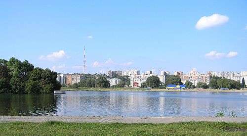
Khmelnytskyi is the regional center of the Khmelnytskyi region which is located in the western part of Ukraine in the middle of Podillia, its total area makes up 8,624 ha (21,310 acres). Khmelnytskyi has a favorable geographical position. Khmelnytskyi is crossed by one of the longest rivers of Ukraine – the Southern Bug. Coincidentally, through the western portion of the city flows small river Ploska.
The climate of Khmelnytskyi is moderately continental. The average temperature of Khmelnytskyi in its warmest month (July) is 20 to 22 °C (68 to 72 °F), and the average temperature in the coldest month (January) is −5 to −6 °C (23 to 21 °F). The maximum temperatures in the summer on average reaches 36 to 38 °C (97 to 100 °F), and the minimum temperatures in the winter on average is −24 to −30 °C (−11 to −22 °F). Khmelnytskyi's average annual temperature is 7 to 8 °C (45 to 46 °F). Khmelnytskyi's average annual precipitation is 510 to 580 mm (20.08 to 22.83 in).
The most abundant make up for the ground in Khmelnytskyi are layers of the following overburden: loess and loess-type rocks. The ground-climatic conditions of Khmelnytskyi are favorable for the cultivation of winter wheat and rye, sugar beet, potato and other crops. Khmelnytskyi is also ideal for the development of gardening and vegetable growing. In the territory of Khmelnytskyi there are the vegetations of two geobotanical zones of Ukraine: Polissya and forest-steppe. Khmelnytskyi and its greater region supplies many rock products, particularly building materials such as: limestone, plaster, chalk, tripoli powder, crystal layers (granites, gneisses), sand, sandstones, and also graphite, saponite, kaolin, phosphorite, lithographic stone and roofing slate. There are also deposits of peat, bitumen, shale and oil.
| Climate data for Khmelnytskyi (1955-2011) | |||||||||||||
|---|---|---|---|---|---|---|---|---|---|---|---|---|---|
| Month | Jan | Feb | Mar | Apr | May | Jun | Jul | Aug | Sep | Oct | Nov | Dec | Year |
| Record high °C (°F) | 12.0 (53.6) |
17.1 (62.8) |
23.0 (73.4) |
26.5 (79.7) |
31.7 (89.1) |
33.9 (93.0) |
35.5 (95.9) |
34.0 (93.2) |
30.4 (86.7) |
26.6 (79.9) |
20.0 (68.0) |
12.8 (55.0) |
35.5 (95.9) |
| Average high °C (°F) | −2.1 (28.2) |
−0.6 (30.9) |
4.6 (40.3) |
12.9 (55.2) |
19.3 (66.7) |
22.2 (72.0) |
23.9 (75.0) |
23.3 (73.9) |
18.5 (65.3) |
12.3 (54.1) |
4.8 (40.6) |
−0.5 (31.1) |
11.6 (52.9) |
| Daily mean °C (°F) | −4.5 (23.9) |
−3.5 (25.7) |
0.8 (33.4) |
8.0 (46.4) |
13.9 (57.0) |
17.0 (62.6) |
18.6 (65.5) |
17.8 (64.0) |
13.1 (55.6) |
7.7 (45.9) |
2.0 (35.6) |
−2.7 (27.1) |
7.4 (45.3) |
| Average low °C (°F) | −7.4 (18.7) |
−6.5 (20.3) |
−2.7 (27.1) |
3.2 (37.8) |
8.6 (47.5) |
11.8 (53.2) |
13.5 (56.3) |
12.7 (54.9) |
8.4 (47.1) |
3.7 (38.7) |
−0.7 (30.7) |
−5.3 (22.5) |
3.4 (38.1) |
| Record low °C (°F) | −30.5 (−22.9) |
−27.0 (−16.6) |
−23.6 (−10.5) |
−7.2 (19.0) |
−2.8 (27.0) |
2.2 (36.0) |
3.6 (38.5) |
2.1 (35.8) |
−5.0 (23.0) |
−11.4 (11.5) |
−17.8 (0.0) |
−25.4 (−13.7) |
−30.5 (−22.9) |
| Average precipitation mm (inches) | 32.5 (1.28) |
36.4 (1.43) |
30.2 (1.19) |
50.0 (1.97) |
60.6 (2.39) |
94.1 (3.70) |
105.0 (4.13) |
64.4 (2.54) |
58.4 (2.30) |
38.0 (1.50) |
45.5 (1.79) |
41.7 (1.64) |
656.8 (25.86) |
| Average precipitation days | 20.7 | 19.0 | 17.7 | 13.1 | 11.0 | 11.3 | 10.5 | 7.7 | 10.5 | 11.5 | 16.1 | 20.2 | 169.3 |
| Average relative humidity (%) | 87.5 | 85.1 | 78.1 | 65.9 | 65.5 | 71.3 | 74.1 | 72.4 | 75.5 | 80.9 | 88.0 | 88.9 | 77.8 |
| Source: Climatebase.ru[7] | |||||||||||||
Demographics
According to a 2017 survey, 94% of the population are ethnic Ukrainians and 3% are Russians.[8]
The average life expectancy of its inhabitants is 65 years for men, and 75 years for women.
Education
Khmelnytskyi hosts 6 universities, 2 academies, 3 institutes, 12 colleges, 4 technical schools and 15 representative offices of other Ukrainian HEIs.[9][10]
Transport
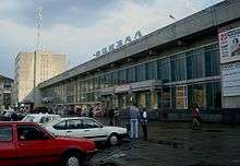
Khmelnytskyi has infrastructure for transportation connections with Moscow, Prague, Bratislava, Warsaw, Budapest, Belgrade and all major Ukrainian cities. The distance from Khmelnytskyi to Kiev by railway is estimated to be 366 km (227 mi), by highway it is estimated to be 384 km (239 mi). The highways Kiev-Lviv, Odessa-Lviv and Chernivtsi-Kiev pass through Khmelnytskyi. The city is served by the Khmelnytskyi Ruzhychna Airport. Khmelnytskyi's airport has a 2,200 m (7,217.85 ft) concrete runway; at the airport there is a check point for crossing the state border of Ukraine.
Sports
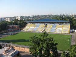
Khmelnytskyi is home to the competitive football team FC Dynamo Khmelnytskyi.
Points of interest

- Proskurivska street, a modern central pedestrian street of the city, preserved buildings of the end of the 19th - the beginnings of 20th century in the styles of modernist, eclecticisms, Baroque, stone (characteristic only for Proskuriv).
- The house of the former Oleksiyivske real school (now it is the building of the City Executive Committee)
- The house of O. Brusilov (now is the House of Ceremonial events)
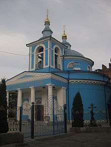
- The church of Nativity of the Virgin (the first stone construction in the city)
- The Protection cathedral
- St. George church
- Andriy Pervozvannyi church in "Dubovo" district
Notable people from Khmelnytskyi
- Ariel Durant, American author and historian
- Alberto Gerchunoff, Argentine author and journalist
- Max Husmann, Swiss peacemaker (Operation Sunrise), educator and founder of Institut Montana Zugerberg
- Alexandra Shevchenko, FEMEN activist
- Anatoly Kashpirovsky, Russian psychotherapist and psychic healer
- Bohdan Shershun, Ukrainian footballer
- Harry A. Marmer, American mathematician and oceanographer
- Mischa Mischakoff, American violinist, teacher, and conductor
- Oleksandr Ponomaryov, Ukrainian singer
- Jakob Reimer (1918–2005), a Trawniki concentration camp guard
- Oksana Shachko, Ukrainian artist and activist with FEMEN
- Natalia Valevskaya, Ukrainian singer
International relations
Twin towns — Sister cities
Khmelnytskyi is twinned with:


In January 2016 the Khmelnytskyi city council terminated its twinned relations with the Russian cities Tver and Ivanovo due to the Russian military intervention in Ukraine (2014–present).[11]
Views of Khmelnytskyi
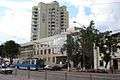 Podilska St, near Trade Center
.jpg) Shevchenko Street - one of the main streets of Khmelnytskyi
Shevchenko Street - one of the main streets of Khmelnytskyi Main square
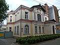 Old building
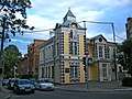 Old town of Khmelnytsky
 Bank building
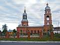 Saint George Cathedral
.jpg) St. Andrew (Andriy Pervozvannyi) church
St. Andrew (Andriy Pervozvannyi) church Protection Cathedral in Khmelnytsky
Notes
- Alternative transliterations of the name include Khmel’nyts’kyỹ, Khmel’nyts’kyy, Khmelnitsky, and Khmelnitskiy.
References
- ЮНЕСКО", Опубліковано Євроклуб "Кур'єри. "Волонтерська турбота про духовні скарби Хмельниччини: Участь європейського клубу "Кур'єри ЮНЕСКО" гімназії №2 м. Хмельницького зі статусом "Асоційована школа ЮНЕСКО" у проекті "Волонтерська турбота про духовні скарби Хмельниччини"". Retrieved 2016-05-03.
- http://i.piccy.info/i9/50c7ec080439bb1790d77fec4b180a08/1437042927/139143/831035/The_Eyalet_of_Kamanice.jpg Map of Podolia Eyalet
- (in Ukrainian) Proskurivsky pogrom. Petliura's fault? by Henry Abramson, Ukrayinska Pravda (25 February 2019)
- Husson, Edouard (11 November 2008). "L'Ukraine et le début de la " solution finale de la question juive en Europe " - Le meurtre des Juifs d'Ukraine par les nazis et leurs collaborateurs - Introduction historique". Centre Européen de Recherche et d'Enseignement sur la Shoah à l'Est. Archived from the original on 13 February 2015. Retrieved 13 February 2015.
- "До 70-річчя останнього розстрілу в'язнів проскурівського гетто". http://biznes.km.ua. 30 November 2012. Retrieved 13 February 2015. External link in
|website=(help) - Feskov, V.I.; Kalashnikov, K.A.; Golikov, V.I. (2004). The Soviet Army in the Years of the Cold War 1945–91. Tomsk: Tomsk University Publishing House. p. 133. ISBN 5-7511-1819-7.
- "Khmelnytskyi, Ukraine Climate Data". Climatebase. Retrieved November 25, 2013.
- "Public Opinion Survey of Residents of UkraineJune 9 – July 7, 2017" (PDF). iri.org. August 2017. p. 83. Archived from the original (PDF) on August 22, 2017.
- "Higher education institutions raiting (Khmelnytskyi)". Retrieved 2017-02-05.
- "List of higher education institutions in Khmelnytskyi". Retrieved 2017-02-05.
- Template:Ukicon Chernivtsi decided to terminate the relationship with twin two Russian cities, The Ukrainian Week (February 27, 2016)
External links
| Wikimedia Commons has media related to Khmelnytskyi. |
| Look up Khmelnytskyi in Wiktionary, the free dictionary. |

- khmelnytsky.com - Khmelnytskyi City Rada website
- Photos of Khmelnytskyi
- Khmelnytskyi Sights and Streets
- The murder of the Jews of Khmelnytskyi during World War II, at Yad Vashem website.
- . Encyclopædia Britannica (11th ed.). 1911.
- Khmelnytskyy, Ukraine at JewishGen
| Raions | |||||
|---|---|---|---|---|---|
| Hromadas | |||||
| Cities |
| ||||
| |||||
| Oblasts | |
|---|---|
| Cities with special status | |
| Autonomous republic | |
| Administrative centers | |
1Claimed and controlled by Russia as the Republic of Crimea and the Federal City of Sevastopol 2Regions are partly controlled by Pro-Russian separatists states of Donetsk People's Republic and Luhansk People's Republic | |
| Authority control |
|
|---|