Cherkasy Oblast
Cherkasy Oblast (Ukrainian: Черкаська область, romanized: Cherkas'ka oblast', pronounced [tʃerˈkɑsʲkɐ ˈɔblɐstʲ]; also referred to as Черкащина Cherkashchyna [tʃerˈkɑʃtʃɪnɐ]) is an oblast (province) of central Ukraine located along the Dnieper River. The administrative center of the oblast is the city of Cherkasy (population: 1,231,207 (2017 est.)[2]).
Cherkasy Oblast Черкаська область | |
|---|---|
 Flag  Coat of arms | |
| Nickname(s): Черкащина (Cherkashchyna) | |
 | |
| Country | |
| Established | January 7, 1954 |
| Administrative center | Cherkasy |
| Largest cities | Cherkasy, Uman, Smila, Zolotonosha |
| Government | |
| • Governor | Roman Bodnar[1] |
| • Oblast council | 84 seats |
| • Chairperson | Anatoliy Pidhornyy |
| Area | |
| • Total | 20,900 km2 (8,100 sq mi) |
| Area rank | Ranked 18th |
| Population (2017) | |
| • Total | 1,231,207 |
| • Rank | Ranked 15th |
| • Density | 59/km2 (150/sq mi) |
| Demographics | |
| • Official language(s) | Ukrainian |
| • Average salary | UAH 817 (2006) |
| Time zone | UTC+2 (EET) |
| • Summer (DST) | UTC+3 (EEST) |
| Postal code | 18-20xxx |
| Area code | +380 47 |
| ISO 3166 code | UA-71 |
| Vehicle registration | CA |
| Raions | 20 |
| Cities (total) | 25 |
| • Regional cities | 6 |
| Urban-type settlements | 34 |
| Villages | 838 |
| FIPS 10-4 | UP01 |
| Website | www.oda.ck.ua www.rada.gov.ua |
Geography
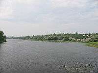
With 20,900 km², the Cherkasy oblast is the 18th largest oblast of Ukraine, comprising about 3.5% of the area of the country. The south flowing Dnieper River with the hilly western bank and the plain eastern bank divides the oblast into two unequal parts. The larger western part belongs to the Dnieper Upland. The low-lying eastern part of the oblast used to be subject to the frequent Dnieper flooding before the flow of the river became controlled by multiple dams of Hydroelectric Power Plants constructed along the river in the 20th century.
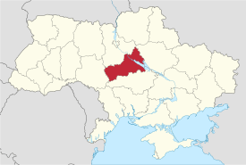
The oblast extends for 245 km from south-west to north-east, and for 150 km from north to south. The northernmost point of the oblast is located is near the village of Kononivka in the Drabivskyi Raion (district), the southernmost point near the village of Kolodyste in the Talnivskyi Raion, the westernmost point near the village of Korytnya in the Zhashkivskyi Raion, and the easternmost point near the village of Stetsivka in the Chyhyrynsky Raion. The geometric centre of the oblast is located near the village Zhuravky of the Horodyshchenskyi Raion. The oblast borders the Kyiv Oblast to the north, the Kirovohrad Oblast to the south, the Poltava Oblast to the east, and the Vinnytsia Oblast to the west.
History
The Cherkasy Oblast was created as part of the Ukrainian Soviet Socialist Republic on January 7, 1954. The oblast's territory was the major cities of Cherkasy, Smila and Uman, their corresponding raions (districts), as well as 30 former raions of the Vinnytsia, Kiev, Kirovohrad and Poltava Oblasts.
Archaeological discoveries, have shown that people have inhabited the valley of the Dnieper (Dnipro) River since the times immemorial. The oldest objects excavated on the territory of the region date back to the Stone Age – the Palaeolithic period.
Administrative divisions

Cherkasy Oblast is administratively subdivided into 20 raions (districts), as well as 6 cities (municipalities) which are directly subordinate to the oblast government: Vatutine, Zolotonosha, Kaniv, Smila, Uman, and the administrative center of the oblast, Cherkasy. There are a total of 25 cities, 34 towns, and 838 villages.
The following data incorporates the number of each type of administrative divisions of Cherkasy Oblast:
- Administrative Center—1 (Cherkasy);
- Raions—20;
- City raions—2;
- Settlements—855, including:
- Villages—824;
- Cities/Towns—31, including:
- Urban-type settlements—15;
- Cities—16, including:
- Cities of oblast subordinance—6;
- Cities of raion subordinance—10;
- Selsovets—525.
The local administration of the oblast is controlled by the Cherkasy Oblast Rada. The governor of the oblast is the Cherkasy Oblast Rada speaker, appointed by the President of Ukraine.
| Name | Ukrainian Name | Area (km2) | Population census 2015[3] | Admin.center | Urban Population Only |
|---|---|---|---|---|---|
| Cherkasy | Черка́си (місто) | 69 | 284,479 | Cherkasy (city) | 283,610 |
| Kaniv | Канів (місто) | 18 | 25,169 | Kaniv (city) | 25,169 |
| Smila | Сміла (місто) | 40 | 68,664 | Smila (city) | 68,657 |
| Uman | Умань (місто) | 41 | 86,050 | Uman (city) | 86,050 |
| Vatutine | Ватутіне (місто) | 11 | 17,616 | Vatutine (city) | 16,958 |
| Zolotonosha | Золотоноша (місто) | 22 | 29,277 | Zolotonosha (city) | 28,301 |
| Cherkaskyi Raion | Черкаський (район) | 1,617 | 75,758 | Cherkasy (city) | N/A * |
| Chornobaivskyi Raion | Чорнобаївський (район) | 1,554 | 41,217 | Chornobai | 7,312 |
| Chyhyrynskyi Raion | Чигири́нський (район) | 1,217 | 27,012 | Chyhyryn | 9,002 |
| Drabivskyi Raion | Драбівський (район) | 1,160 | 35,387 | Drabiv | 9,349 |
| Horodyshchevskyi Raion | Городищенський (район) | 883 | 40,986 | Horodyshche | 18,562 |
| Kamyanskyi Raion | Кам'янканський (район) | 726 | 27,539 | Kamianka | 12,059 |
| Kanivskyi Raion | Канівський (район) | 1,282 | 19,218 | Kaniv (city) | N/A * |
| Katerynopilskyi Raion | Катеринопільський (район) | 672 | 24,337 | Katerynopil | 9,740 |
| Khrystynivskyi Raion | Христинівський (район) | 632 | 35,108 | Khrystynivka | 14,533 |
| Korsun-Shevchenkivskyi Raion | Новобузький (район) | 896 | 43,296 | Korsun-Shevchenkivskyi | 21,994 |
| Lysianskyi Raion | Лисянський (район) | 746 | 23,808 | Lysianka | 7,998 |
| Mankivskyi Raion | Маньківський (район) | 765 | 27,773 | Mankivka | 9,642 |
| Monastyryshenskyi Raion | Монастирищенський (район) | 720 | 36,395 | Monastyryshche | 12,575 |
| Shpolyaskyi Raion | Шполянський (район) | 1,106 | 43,729 | Shpola | 17,331 |
| Smilyanskyi Raion | Смілянський (район) | 934 | 32,422 | Smila (city) | N/A * |
| Talnivskyi Raion | Тальнівський (район) | 910 | 34,371 | Talne | 14,048 |
| Umanskyi Raion | Уманський (район) | 1,393 | 43,046 | Uman (city) | N/A * |
| Zhashkivskyi Raion | Жашківський (район) | 964 | 37,310 | Zhashkiv | 14,111 |
| Zolotonskyi Raion | Золотоніський (район) | 1,492 | 41,605 | Zolotonosha (city) | N/A * |
| Zvenyhorodskyi Raion | Звенигородський (район) | 1,010 | 44,594 | Zvenyhorodka | 17,463 |
Note: Asterisks (*) Though the administrative center of the rayon is housed in the city/town that it is named after, cities do not answer to the rayon authorities only towns do; instead they are directly subordinated to the oblast government and therefore are not counted as part of rayon statistics.
Cities
The region has 16 populated places that are cities.
Demographics
The current estimated population is 1,335,064 (as of 2006).
According to the 2001 Ukrainian census, the oblast's population is almost equally divided between the urban and rural areas (53.7% and 46.3%, respectively).[4] The demographic situation in this largely agricultural territory is somewhat complicated by population ageing.[5]
By ethnic composition, Ukrainians represent the overwhelming majority of the oblast's population (93.6%).[6] Ethnic Russians are the distant second group of population (5.4%), and are concentrated mainly in the city of Cherkasy.
The oblast is primarily Ukrainophone.
Age structure
- 0-14 years: 13.4%

- 15-64 years: 69.1%

- 65 years and over: 17.5%
Median age
- total: 41.7 years

- male: 38.4 years
- female: 45.0 years
Economy
The economy of the Cherkasy Oblast is largely dominated by agriculture. While the winter wheat and sugar beets are the main products grown in the oblast, barley, corn, tobacco and hemp are also grown. Cattle breeding is also important.
The industry is mainly concentrated in Cherkasy, the oblast's capital and the largest city. A chemical industry was developed in the city in late 1960s in addition to machine building, furniture making and agricultural processing.
Nomenclature
Most of Ukraine's oblasts are named after their capital cities, officially referred to as "oblast centers" (Ukrainian: обласний центр, translit. oblasnyi tsentr). The name of each oblast is a relative adjective, formed by adding a feminine suffix to the name of respective center city: Cherkasy is the center of the Cherkas’ka oblast’ (Cherkasy Oblast). Most oblasts are also sometimes referred to in a feminine noun form, following the convention of traditional regional place names, ending with the suffix "-shchyna", as is the case with the Cherkasy Oblast, Cherkashchyna.
Education
There are 5 universities in the region:
- The Bohdan Khmelnytsky National University of Cherkasy
- Cherkasy State Technological University
- Uman National University Of Horticulture
- Pavlo Tychyna Uman State Pedagogical University
- East European University of Economics and Management (private)
Attractions
- Sofiivka
- Fatherland of Taras Shevchenko
- Trypillian culture
- Shevchenko National preserve
- Martynivka Treasure housed in Kiev
See also
- Administrative divisions of Ukraine
- Right and Left-bank Ukraine, historical region
References
- Zelensky replaces head of Cherkasy Regional State Administration – decrees, Interfax-Ukraine (4 November 2019)
- "Чисельність наявного населення України (Actual population of Ukraine)" (in Ukrainian). State Statistics Service of Ukraine. Retrieved 26 August 2017.
- "Population Quantity" (PDF). UkrStat (in Ukrainian). Retrieved 30 January 2016.
- "General results of the census / Urban and rural population / Cherkasy region". 2001 Ukrainian Census. Archived from the original on 2007-09-27. Retrieved 2007-06-03.
- "General results of the census / Age composition of population / Cherkasy region". 2001 Ukrainian Census. Archived from the original on 2007-09-30. Retrieved 2007-06-03.
- "General results of the census / National composition of population / Cherkasy region". 2001 Ukrainian Census. Archived from the original on 2007-07-02. Retrieved 2007-06-03.
- "Cherkasy Region". Cabinet of Ministers of Ukraine. Retrieved 2007-06-01.
- (1972) Історіа міст і сіл Української CCP - Черкаська область (History of Towns and Villages of the Ukrainian SSR - Cherkasy Oblast), Kiev. (in Ukrainian)
External links
| Wikimedia Commons has media related to Cherkasy Oblast. |
- oda.ck.ua—Official website of Cherkasy Oblast Administration (in Ukrainian, Russian, and English)
- ukrainebiz.com—Cherkasy oblast: facts and figures
| Raions | |||||
|---|---|---|---|---|---|
| Hromadas | |||||
| Cities |
| ||||
| |||||
| Oblasts | |
|---|---|
| Cities with special status | |
| Autonomous republic | |
| Administrative centers | |
1Claimed and controlled by Russia as the Republic of Crimea and the Federal City of Sevastopol 2Regions are partly controlled by Pro-Russian separatists states of Donetsk People's Republic and Luhansk People's Republic | |
| Authority control |
|---|