Southern Bug
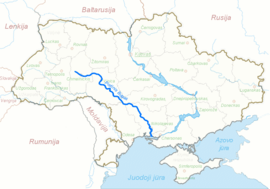
The Southern Bug, also called Southern Buh[1] (Ukrainian: Південний Буг, Pivdennyi Buh; Russian: Южный Буг, Yuzhny Bug),[1] and sometimes Boh River,[2] is a navigable river located in Ukraine. It is the second-longest river in Ukraine.
| Southern Bug Ukrainian: Південний Буг, Pivdennyi Buh | |
|---|---|
 | |
 Southern Bug through Ukraine | |
| Location | |
| Country | Ukraine |
| Physical characteristics | |
| Source | |
| ⁃ location | Khmelnytskyi Oblast, Ukraine |
| Mouth | |
⁃ location | Bug Estuary, Ukraine |
| Length | 806 km (501 mi) |
| Basin size | 63,700 km2 (24,600 sq mi) |
| Discharge | |
| ⁃ average | 108 m3/s |
| Basin features | |
| Progression | Dnieper–Bug estuary→ Black Sea |
The source of the river is in the west of Ukraine, in the Volyn-Podillia Upland, about 145 kilometres (90 miles) from the Polish border, from where it flows southeasterly into the Bug Estuary (Black Sea basin) through the southern steppes. It is 806 kilometres (501 miles) long and drains 63,700 square kilometres (24,600 sq mi).[3]
Major cities on the Southern Bug are Khmelnytskyi, Khmilnyk, Vinnytsia, Haivoron, Pervomaisk, Voznesensk and Mykolaiv (listed downstream, i.e. southwards).[3]
Between 1941 and 1944 during World War II the Southern Bug formed the border between the German-occupied Ukraine and the Romanian-occupied part of Ukraine, called Transnistria.
Nomenclature, etymology and history
(Ukrainian: Південний Буг, Pivdennyi Buh; Polish: Boh; Russian: Южный Буг; Ottoman Turkish: Aksu)
Herodotus (c. 484–425 BCE) refers to the river using its ancient Greek name: Hypanis.[4] During the Migration Period of the 5th to the 8th centuries CE the Southern Bug represented a major obstacle to all the migrating peoples in the area.
The long-standing local Slavic name of the river, Boh (Cyrillic: Бог),[2] may derive from a root meaning "rich" (Ukrainian: бaгата, bahata). The 17th-century French military engineer and geographer Guillaume Le Vasseur de Beauplan (Ukrainian: Ґійом Левассер де Боплан) recorded the name of the river as Boh Ruthenian (Ukrainian: Бог Руський, Boh Ruskyi).[5]
From the 16th to the 18th centuries most of the Southern Ukraine formed part of the Crimean Khanate and/or of the Ottoman Empire; the river had the Turkic name Aq-su, meaning the "White river".
"Bug", a Russian name, became established during the colonial period in Ukraine and known internationally. It was a misnomer given by a Russian geologist Vladimir Laskaryev at the beginning of 20th century.
On March 6, 1918 the Central Council of Ukraine (Tsentralna Rada of the Ukrainian People's Republic) adopted the law "For the administrative-territorial division of Ukraine", dividing Ukraine into numerous lands. One of those lands in the upper stream of the river was named "Boh land" (Ukrainian: Побожжя, Pobozhia). Previously in the 18th century there had existed the Bohogard phalanx (Ukrainian: Бoгоґардівська паланка, Bohogardivska palanka) as part of the Zaporizhian Sich centered in the city of Gard (today – a tract near Yuzhnoukrainsk).
Tributaries
The main tributaries of the Southern Bug are, from source to mouth (length in parentheses):
- Left: Buzhok (75), Ikva (57), Snyvoda (58), Desna (80), Sob (115), Udych (56), Synytsia (78), Synyukha (111), Velyka Korabelna (45), Mertvovid (114), Hnylyi Yelanets (103), Inhul (354)
- Right: Vovk (71), Zghar (95), Riv (104), Silnytsia (67), Dokhna (68), Savran (97), Kodyma (149), Bakshala (57), Chychyklia (156)
Bridges and ferries
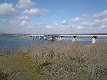
The Varvarivskyi Bridge over Southern Bug in Mykolayiv is a swing bridge (facilitating ship building) with Europe's largest span (134 m).[6] It is also the southernmost bridge over the river.
Navigation
The river is technically navigable for dozens of kilometers up from its mouth; several riverports (such as Mykolayiv) exist.
In 2011, plans were announced to revive commercial freight navigation on the Southern Bug northerly of Mykolayiv to facilitate the increasing grain export from Ukraine.[7] As of April 2018, freight navigation is renewed and active between the eastuary and the grain terminal in the village of Prybuzhany (located in Voznesensk Raion in central part of the Mykolaiv Oblast) newly-built by Nibulon.
Gallery
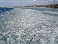 Winter-frozen Southern Bug in Mykolaiv.
 The Ploska River emptying into the Southern Bug.
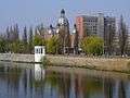 Southern Bug in Vinnytsia.
 A riverboat on the river in Vinnytsia (2006).
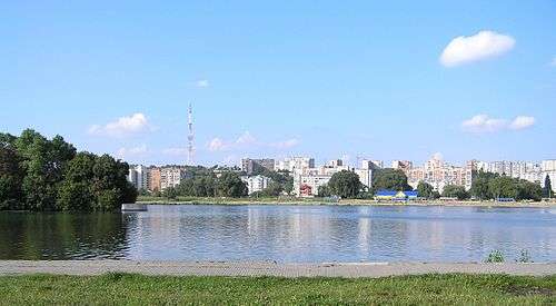 Riverside skyline of Khmelnytskyi.
 Southern Bug in vicinity of the Granite-steppe lands of Bug landscape park.
.jpg) Southern Bug in Medzhybizh
Southern Bug in Medzhybizh
References
- "Encyclopædia Britannica: Southern Buh (River)". Encyclopædia Britannica. Retrieved May 8, 2011.
- Boh River at the Encyclopedia of Ukraine
- Южный Буг, Great Soviet Encyclopedia
- The Histories, Herodotus p.165. Books.google.com. 2009-01-30. Retrieved 2013-01-05.
-
Compare:
Le Vasseur de Beauplan, Guillaume (1651). Golitsyn, Avgustin Petrovich (ed.). Description de l'Vkranie depvis les confins de la Moscovie jvsqu'avx limites de la Transylvanie [Description of the Ukraine from the borders of Muscovy to the limits of Transylvania]. Bibliothèque russienne (in French). Paris: J. Techener (published 1861). p. 57. Retrieved 2014-10-30.
A trois lieues audessus de Douczakow [Ochakiv] est l'emboucheure du Bog où se trouve vne isle en forme de triangle, viron de demi lieue de long le trauers de Semenwiruk. [...] Au dessus de Semenwirut, il y a sur le Bog Winaradnakricza, qui est vne fontaine sur vn précipice, lieu beau et propre à habiter, tant pour le bois qui est à commodité que pour les moulins qui s'y pourraient faire.
- "History". Kyivdiprotrans Institute. Archived from the original on 30 December 2013. Retrieved 19 August 2013.
- «НИБУЛОН» заложил основу собственного флота(in Ukrainian)
External links
| Wikimedia Commons has media related to Southern Bug. |
- Southern Buh rafting
- (in Polish) Boh in the Geographical Dictionary of the Kingdom of Poland (1880)
- (in Russian) Photos of the Southern Buh coasts
- (in Russian) Southern Buh rafting, photo