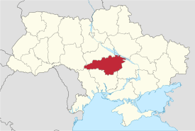
Kirovohrad Oblast
Kirovohrad Oblast (Ukrainian: Кіровоградська область, translit. Kirovohrads’ka oblast’; also referred to as Kirovohradschyna - Ukrainian: Кіровоградщина) is an oblast (province) of Ukraine. The administrative center of the oblast is the city of Kropyvnytskyi, formerly known as Kirovohrad. Its population is 965,756 (2017 est.)[2]. Between 1939 and 2016, Kropyvnytskyi was called Kirovohrad and was named after the First Secretary of the Leningrad City Committee of the All-Union Communist Party (Bolsheviks) Sergei Kirov.[3] Due to decommunization laws (on 14 July 2016) the name of the city was changed to Kropyvnytskyi.[3] Kirovohrad Oblast was not renamed because as such it is mentioned in the Constitution of Ukraine, and the Oblast can only be renamed by a constitutional amendment.[4] On 20 June 2018, the Committee on State Building, Regional Policy and Local Self-Government of the Ukrainian parliament backed the proposal to rename Kirovohrad Oblast to Kropyvnytskyi Oblast.[5] In February 2019, the Constitutional Court of Ukraine declared constitutional the bill on renaming Kirovohrad Oblast to Kropyvnytskyi Oblast.[6][7]
Kirovohrad Oblast Кіровоградська область Kirovohrads’ka oblast’ | |
|---|---|
 Flag  Coat of arms | |
| Nickname(s): Кіровоградщина (Kirovohradschyna) | |
 | |
| Coordinates: 48.46°N 32.27°E | |
| Country | |
| Administrative center | Kropyvnytskyi |
| Government | |
| • Governor | Andriy Balon[1] |
| • Oblast council | 64 seats |
| • Chairperson | Oleksandr Chornoivanenko (Batkivshchyna) |
| Area | |
| • Total | 24,588 km2 (9,493 sq mi) |
| Area rank | Ranked 15th |
| Population (2017) | |
| • Total | 965,756 |
| • Rank | Ranked 25th |
| • Density | 39/km2 (100/sq mi) |
| Time zone | UTC+2 (EET) |
| • Summer (DST) | UTC+3 (EEST) |
| Postal code | 25000-27999 |
| Area code | +380-52 |
| ISO 3166 code | UA-35 |
| Vehicle registration | ВA |
| Raions | 21 |
| Cities (total) | 12 |
| • Regional cities | 4 |
| Urban-type settlements | 26 |
| Villages | 1015 |
| FIPS 10-4 | UP10 |
| Website | kr-admin.gov.ua |
Geography
The area of the province is 24,600 km2 (9,498.11 sq mi).
The city of Dobrovelychkivka is the geographical center of Ukraine.
History
The oblast was created as part of the Ukrainian Soviet Socialist Republic on January 10, 1939 out of the northern raions of Mykolaiv Oblast. In 1954 the oblast lost some raions to the newly created Cherkasy Oblast, but later that year received its western raions from the Odessa Oblast.
Points of interest
The following sites were nominated for the Seven Wonders of Ukraine:
- Khutir Nadia
- Saint Elizabeth fortress
- Oblast art museum
Administrative divisions
The Kirovohrad Oblast is administratively subdivided into 21 raions (districts) as well as 4 cities (municipalities) which are directly subordinate to the oblast government: Oleksandriia, Svitlovodsk, Znamianka, and the administrative center of the oblast, Kropyvnytskyi.
| Name | Ukrainian Name | Area (km2) | Population census 2015[8] | Admin.center | Urban Population Only |
|---|---|---|---|---|---|
| Kropyvnytskyi | Кропивницький (місто) | 103 | 239,837 | Kropyvnytskyi (city) | 231,228 |
| Oleksandriia | Олександрія (місто) | 55 | 91,881 | Oleksandriia (city) | 82,269 |
| Svitlovodsk | Світловодськ (місто) | 45 | 53,449 | Svitlovodsk (city) | 45,746 |
| Znamianka | Знам'янка (місто) | 15 | 28,507 | Znamianka (city) | 23,245 |
| Bobrynets'kyi raion | Бобринецький район | 1,496 | 25,993 | Bobrynets | 10,998 |
| Dobrovelychkivs'kyi raion | Добровеличківський район | 1,297 | 33,925 | Dobrovelychkivka | 14,726 |
| Dolyns'kyi raion | Долинський район | 1,200 | 34,535 | Dolynska | 20,713 |
| Haivorons'kyi raion | Гайворонський район | 700 | 38,335 | Haivoron | 21,556 |
| Holovanivs'kyi raion | Голованівський район | 992 | 31,084 | Holovanivsk | 11,996 |
| Kropyvnytskyi Raion | Кропивницький район | 1,600 | 37,123 | Kropyvnytskyi (city) | N/A * |
| Kompaniyivs'kyi raion | Компаніївський район | 967 | 15,413 | Kompaniivka | 4,537 |
| Malovyskivs'kyi raion | Маловисківський район | 1,111 | 43,678 | Mala Vyska | 20,660 |
| Novhorodkivs'kyi raion | Новгородківський район | 997 | 15,567 | Novhorodka | 5,775 |
| Novoarkhanhel's'kyi raion | Новоархангельський район | 1,200 | 24,743 | Novoarkhanhelsk | 6,286 |
| Novomyrhorods'kyi raion | Новомиргородський район | 1,032 | 28,554 | Novomyrhorod | 13,894 |
| Novoukrains'kyi raion | Новоукраїнський район | 1,668 | 42,055 | Novoukrainka | 17,176 |
| Oleksandrivs'kyi raion | Олександрівський район | 1,159 | 27,558 | Oleksandrivka | 11,279 |
| Oleksandriys'kyi raion | Олександрійський район | 1,854 | 35,765 | Oleksandriia (city) | N/A * |
| Onufriyivs'kyi raion | Онуфріївський район | 889 | 18,445 | Onufriivka | 8,695 |
| Petrivs'kyi raion | Петрівський район | 1,195 | 24,329 | Petrove | 8,173 |
| Svitlovods'kyi raion | Світловодський район | 1,219 | 12,420 | Svitlovodsk (city) | N/A * |
| Ul'yanovs'kyi raion | Ульяновський район | 701 | 22,742 | Ulianovka | 6,080 |
| Ustynivs'kyi raion | Устинівський район | 942 | 13,106 | Ustynivka | 3,467 |
| Vilshans'kyi raion | Вільшанський район | 645 | 12,650 | Vilshanka | 4,689 |
| Znamyans'kyi raion | Знам'янський район | 1,334 | 23,030 | Znamianka (city) | N/A * |
| Total Oblast | Кіровоградська Область | 24,588 | 974,724 | 612,237 |
Note: Asterisks (*) Though the administrative center of the rayon is housed in the city/town that it is named after, cities do not answer to the rayon authorities only towns do; instead they are directly subordinated to the oblast government and therefore are not counted as part of rayon statistics.
Demographics
Age structure
- 0-14 years: 14.3%

- 15-64 years: 68.7%

- 65 years and over: 17.0%

Median age
- total: 41.2 years
- male: 37.7 years
- female: 44.5 years
Nomenclature
Most of Ukraine's oblasts are named after their capital cities, officially referred to as "oblast centers" (Ukrainian: обласний центр, translit. oblasnyi tsentr). The name of each oblast is a relative adjective, formed by adding a feminine suffix to the name of respective center city: Kirovohrad is the center of the Kirovohrads’ka oblast’ (Kirovohrad Oblast). Most oblasts are also sometimes referred to in a feminine noun form, following the convention of traditional regional place names, ending with the suffix "-shchyna", as is the case with the Kirovohrad Oblast, Kirovohradshchyna.
See also
References
- "Zelensky appoints new Kirovohrad region governor". Interfax-Ukraine. November 11, 2019. Retrieved November 11, 2019.
- "Чисельність наявного населення України (Actual population of Ukraine)" (in Ukrainian). State Statistics Service of Ukraine. Retrieved 26 August 2017.
- Goodbye, Lenin: Ukraine moves to ban communist symbols, BBC News (14 April 2015)
(in Ukrainian) Verkhovna Rada renamed Kirovograd, Ukrayinska Pravda (14 July 2016) - Ukraine, The World Factbook
- Ukraine's parliament committee backs renaming of Dnipropetrovsk, Kirovohrad regions, UNIAN (20 June 2018)
- "Надано Висновок Конституційного Суду України в справі щодо перейменування Кіровоградської області | Конституційний Суд України". www.ccu.gov.ua. Retrieved 2019-06-13.
- "Constitutional Court Declares Bill Renaming Kirovohrad Region As Kropyvnytskyi Region Constitutional". ukranews_com. 2019-02-06. Retrieved 2019-06-13.
- "Population Quantity". UkrStat (in Ukrainian). Archived from the original on 13 October 2015. Retrieved 7 January 2016.
External links
- "Main". Official web-site of the Kirovohrad Oblast State Administration (in Ukrainian). Archived from the original on 13 August 2006. Retrieved 7 April 2014.
| Raions | |||||
|---|---|---|---|---|---|
| Hromadas | |||||
| Cities |
| ||||
| |||||
| Oblasts | |
|---|---|
| Cities with special status | |
| Autonomous republic | |
| Administrative centers | |
1Claimed and controlled by Russia as the Republic of Crimea and the Federal City of Sevastopol 2Regions are partly controlled by Pro-Russian separatists states of Donetsk People's Republic and Luhansk People's Republic | |
| Authority control |
|
|---|