Bagrot Valley
Bagrote Valley (Urdu: وادی بگروٹ) is a valley in the Karakoram Mountain range in the Gilgit–Baltistan region of northern Pakistan.[2] [3] River Bagrote flows through the valley from north towards southwest of the valley, supplies water to Jalalabad and Oshikhandass and merges with the Gilgit River.
وادی بگروٹ | |
|---|---|
Bagrote Valley | |
 | |
| Country | |
| Autonomous state | Gilgit-Baltistan |
| District | Gilgit |
| Tehsil | Danyore |
| Population | |
| • Total | 25,000 |
| Demonym(s) | Bagoreh |
| Time zone | UTC+5:30 (PST) |
| • Summer (DST) | +5 |
| Postal code | 15110 |
Geography
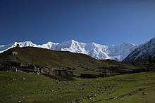
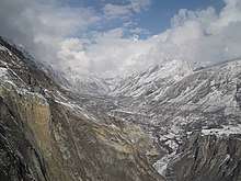
The Bagrot valley extends between 2,500 and 4500 meters above sea level. The principle locality of the valley is Farfu (formerly called Furpui), also known for its spectacular landscape and high mountains such as Rakaposhi 7788 m, Diran 7266 m[4], Bilchar Dobani 6138 m and the summit of Fafuraj , Miar Peak, Godeli and many other peaks that surpass six thousand meters above sea level. Doboi glaciers, Gargo, Yunay, Boi Pharai, Hurangi and Raka Poshi surround the valley from where the rivulets forming the Bagrot River are traced.[5] The River Bagrot passes by all the villages of the valley, including Jalalabad and Oshikhandass and merges with the Gilgit River.

The Bagrot valley extends between 2,500 and 4500 meters above sea level. The principle locality of the valley is Farfu (formerly called Furpui), also known for its spectacular landscape and high mountains such as Rakaposhi 7788 m, Diran 7266 m[4], Dubani 6138 m and the summit of Fafuraj, Miar Peak , Godeli and many other peaks that surpass six thousand meters above sea level. Doboi glaciers, Gargo, Yunay, Boi Pharai, Hurangi and Raka Poshi surround the valley from where the rivulets forming the Bagrot River are traced. Bagrote Valley is in the Karakoram Mountain range in the Gilgit–Baltistan region. River Bagrote flows through the valley from north towards southwest of the valley, supplies water to Jalalabad and Oshikhandass and merges with the Gilgit River. This is valley 38 km away from Gilgit and traveling time is two hours plus till Gasunar valley. Geographically it has Rakaposhi ( Raki poshi) and its glacier from where people from Gilgit fetch Ice for commercial purposes. This valley was hidden from even local population due to obvious reasons: that was road condition. Now 2/3rd of the road is metalled and the rest is in a condition that even a small car can travel on it. The valley blessed with numinous springs, gushing rivers, lofty peaks, glaciers and best part is organic fruits and vegetables. The last village is known as Sath Gasunar (also known as Gasunar valley, must visit point). It has jumping point for trekkers to traverse Haramosh Valley. From Gasunar valley Rakaposhi mountain is visible. This side of Rakaposhi mountain has more greenery and less crowd.
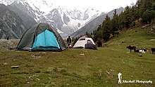
The valley has limited hotel rooms available, but camping is always a good option. From Gilgit it is the nearest picnic spot. 4x4 Jeep is the most suitable transport but you can also travel in any sort of car or motor bike.
As per story tellers, the actual fairy-meadows lies in this area. In local language "Daiayal" , a male/female selected by fairies, after sniffing smoke of junipers tree leaves starts talking to the fairies. Fairies tell "Daiayal" future and also give solutions to the problems of people.
Demography

Shina language is spoken and understood in all villages of Bagrote. The vernacular of Bagrote valley is typical and distinguishable as a dialect, with their lifestyle, cuisines, and culture Bagoreh form an ethnic group.

Tourism and Economy
Tourists visit this valley mostly in summer. The valley is about half an hour's drive from Gilgit city. This is the nearest tourist destination to Gilgit. The side of the Rakaposhi mountain towards Bagrot valley is better for camping due to the lush green forests and less crowd. This valley is known for its fruits and vegetables, also for the glaciers and high peaks. Vegetables, fruits, and other seasonal crops and Ice from the Glaciers during summers is transported from the valley to the capital Gilgit, myths suggest this ice has healing powers. So far no ice factory is working in Gilgit region. Ice brought from the Glacier of Bagrot is even transported to Ghizer District .
The villages of Hamaran, Sinaker, Datuchi, Bulchi, Chirah, Farfu and Hopay lie here and are interconnected by an unmettalled road. Villages on either side of the valley are linked via cable cars (allowing for easy transport of goods and livestock) and wooden bridges, the river passes underneath which comes from glaciers of Karakoram Range.The means of economy is agriculture. However, with the recent construction of the Karakorum Highway, the area has been exposed to western civilization, with small cinemas, retail outlets for mountain equipment and apparel, and small hotels opening to facilitate visitors.
Locals grow Wheat, tomatoes, potatoes, apples, pears, apricots etc. in the valley.[6][7]

Vallies nearby
| Wikimedia Commons has media related to Bagrote Valley. |
References
- "Bagrote Valley Pakistan" (PDF). Archived from the original (PDF) on 2015-09-22. Retrieved 2014-08-27.
- "Bagrote Valley Gilgit-Baltistan". Archived from the original on 2009-04-20. Retrieved 2009-09-03.
- Explore Pakistan Tourism
- "Panoramio - Photo of Diran | Diran Peak Bagrote Gilgit". www.panoramio.com. Archived from the original on 2016-09-16. Retrieved 2017-12-19.
- "Bagrot valley of Gilgit loses forests, the only source of livelihood". thenaturenews.com. Archived from the original on 2016-03-08. Retrieved 2017-09-13.
- "Bagrote Valley" (PDF). Archived from the original (PDF) on 2015-09-22. Retrieved 2014-08-27.
- "Bagrot valley of Gilgit loses forests, the only source of livelihood". Archived from the original on 2016-03-08. Retrieved 2017-09-13.

Gallery