Baltoro Glacier
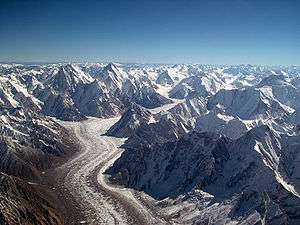
The Baltoro Glacier (Urdu: بالتورو گلیشیر), at 63 km (39 mi) in length, is one of the longest glaciers outside the polar regions.[1] It is located in the Gilgit-Baltistan region of Pakistan. It runs through part of the Karakoram mountain range. The Baltoro Muztagh lies to the south and east of the glacier, while the Masherbrum Mountains lie to the south. At 8,611 m (28,251 ft), K2 is the highest mountain in the region, and three other Eight thousanders within 20 km.[2]
| Baltoro Glacier بالتورو گلیشیر | |
|---|---|
 The Baltoro Glacier from the air, looking east | |
| Type | Mountain glacier |
| Location | Karakoram range, Gilgit-Baltistan, Pakistan |
| Coordinates | 35°44′11″N 76°22′51″E |
| Length | 63 kilometres (39 mi) |
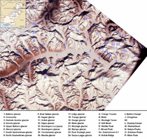
The glacier gives rise to the Braldo River which is a tributary of Shigar River, which is a tributary of the Indus River. Several large tributary glaciers feed the main Baltoro Glacier, including the Godwin Austen Glacier, flowing south from K2; the Abruzzi and the various Gasherbrum Glaciers, flowing from the Gasherbrum group of peaks; the Vigne Glacier, flowing from Chogolisa, and the Yermandendu Glacier, flowing from Masherbrum. The confluence of the main Baltoro Glacier with the Godwin Austen Glacier is known as Concordia; this location and K2 base camp are popular trekking destinations.
The trough of this glacier is very wide. Small valley glaciers form icefalls where they meet the trunk glacier. The sidewalls vary from very steep to precipitous. The glacier has carved striations on the surrounding country rocks. Moving ice has formed depressions, which serve as basins for numerous glacial lakes.
The glacier can be approached via the Balti town of Skardu.
List of peaks
A list of notable peaks adjacent to or near the Baltoro Glacier includes:
- K2, 2nd highest in the world at 8611m
- Gasherbrum I, 11th highest in the world at 8,080m.
- Broad Peak, 12th highest in the world at 8,047m.
- Gasherbrum II, 13th highest in the world at 8,035m.
- Gasherbrum III, 7,946m. (Often regarded as a subpeak of Gasherbrum II.)
- Gasherbrum IV, 17th highest in the world at 7,932m.
- Masherbrum (K1), 22nd highest in the world at 7,821m.
- Chogolisa, 36th highest in the world at 7,665m.
- Muztagh Tower, 7,273m.
- Snow Dome, 7,160m.
- Biarchedi, 6,781 m
- Uli Biaho Tower, 6,417m.
- Trango Towers, 6,286m. (Their vertical faces are the world's tallest cliffs.)
- Mitre Peak, 6,010m.
Image gallery
 Looking NE towards K2, at top centre
 Close-up photo of the glacier
 View of the Baltoro Glacier from Urdukas campsite
 A glacial mushroom on Baltoro Glacier
See also
- Sarpo Laggo Glacier
- Biafo Glacier
- Northern Areas
- Eight-thousander
- List of highest mountains
- List of glaciers
References
| Wikimedia Commons has media related to Baltoro Glacier. |
- The Fedchenko Glacier in the Pamir Mountains of Tajikistan is 77 km long, the Siachen Glacier which lies southeast of the Baltoro is 70 km long, and the Biafo Glacier to the northwest of the Baltoro is 67 km long. Exact lengths are relatively easy to determine with modern maps and imagery so as to include recent glacial retreat. Measurements are from recent imagery, generally supplemented with Russian 1:200,000 scale topographic mapping as well as Jerzy Wala,Orographical Sketch Map: Karakoram: Sheets 1 & 2, Swiss Foundation for Alpine Research, Zurich, 1990.
- Concordia K2 Trek