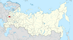
Kaluga Oblast
Kaluga Oblast (Russian: Калу́жская о́бласть, Kaluzhskaya oblast) is a federal subject of Russia (an oblast). Its administrative center is the city of Kaluga. The 2010 Russian Census found a population of 1,010,930.[10]
Kaluga Oblast | |
|---|---|
| Калужская область | |
 Coat of arms | |
| Anthem: Anthem of Kaluga Oblast[1] | |
 | |
| Coordinates: 54°26′N 35°26′E | |
| Country | Russia |
| Federal district | Central[2] |
| Economic region | Central[3] |
| Established | July 5, 1944[4] |
| Administrative center | Kaluga[5] |
| Government | |
| • Body | Legislative Assembly[6] |
| • Governor[7] | Vladislav Shapsha[8] |
| Area | |
| • Total | 29,800 km2 (11,500 sq mi) |
| Area rank | 64th |
| Population (2010 Census)[10] | |
| • Total | 1,010,930 |
| • Estimate (2018)[11] | 1,012,156 (+0.1%) |
| • Rank | 51st |
| • Density | 34/km2 (88/sq mi) |
| • Urban | 76.3% |
| • Rural | 23.7% |
| Time zone | UTC+3 (MSK |
| ISO 3166 code | RU-KLU |
| License plates | 40 |
| OKTMO ID | 29000000 |
| Official languages | Russian[13] |
| Website | http://www.admobl.kaluga.ru/ |
Geography
Kaluga Oblast lies in the central part of the East European Plain. The oblast's territory is located between the Central Russian Upland (with and average elevation of above 200 metres (660 ft) and a maximum elevation of 275 metres (902 ft) in the southeast), the Smolensk–Moscow Upland and the Dnieper–Desna watershed. Most of the oblast is occupied by plains, fields and forests with diverse flora and fauna. The administrative center is located on the Baryatino-Sukhinichy plain. The western part of the oblast — located within the drift plain — is dominated by the Spas-Demensk ridge. To the south is an outwash plain that is part of the Bryansk-Zhizdra woodlands, with average elevation up to 200 m.
From north to south, Kaluga Oblast extends for more than 220 km (140 mi), from 53°30′ to 55°30′ northern altitude, and east to west – for 220 km. Its area is 29,800 square kilometres (11,500 sq mi).
The oblast's territory is crossed by major international motor and railways, linking Kaluga with Moscow, Bryansk, Kyiv, Lviv and Warsaw.
Kaluga Oblast borders on:
- Bryansk Oblast to the south-west
- Oryol Oblast to the south
- Tula Oblast to the east
- Moscow Oblast to the north-east
- Smolensk Oblast to the north-west
- the federal city of Moscow (from July 1, 2012)
Climate
The climate of Kaluga Oblast is moderately continental with distinct seasons: warm and humid summers, and cold winters with stable snow-cover. The average temperature in July is +18 °C (64 °F) in north and +20 °C (68 °F) in south, and in January −11 °C (12 °F) in northeast and −8 °C (18 °F) in southwest. The duration of the warm period (with the average temperatures above zero) is 215–220 days. The territory of the oblast is exposed to a substantial amount of solar radiation — around 115 Kcal per cm². The average annual air temperature varies from 3.5–4.0 °C (38.3–39.2 °F) in the north and the north-east to up to 4.0–4.6 °C (39.2–40.3 °F) in the west and the east of the oblast. The duration of the frost-free season is 113 to 127 days. The northern part of the oblast is the coldest, while the central part is moderately cold. In the south, in the zone of forest steppes, the climate is relatively warm. Precipitation is distributed unevenly, varying from 780 to 826 millimetres (30.7–32.5 in) in the north and the west and up to 690–760 millimetres (27–30 in) in the south.
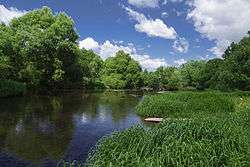
Hydrography
The Oka is the main river in the oblast's river system. Others include the Ugra, the Zhizdra, the Protva, and the Vorya. Lakes include Lakes Bezdon and Svyatoye.
Vegetation
As of 2006, the total area occupied by forests is around 1,380,000 ha (5,300 sq mi, 46% of the territory of the oblast). As of the beginning of 2005, agricultural lands occupied an area of 1,350,000 ha (5,200 sq mi, 44% of the territory). The main crops grown include forage cereals, potatoes, vegetables, and feed grains (wheat, barley, rye, oats, buckwheat), and fiber-flax.
Fauna
Mammals include typical forest animals: brown bear, lynx, elk, wolf, polar hare, and squirrel. The south of the oblast is sometimes visited by bison that were recently released into the Orlovskoye Polesye national park. Aquatic fauna includes two kinds of lamprey and 41 species of bony fish. The diversity of fish is explained by the variety of habitats. Among 11 kinds of amphibians, the most common are crested and common newts, red-bellied, common and green toads, and various lake, pool, moor and grass frogs. Reptiles are represented by 7 species, including snakes: the venomous adder and the harmless water snake and smooth snake.
There are 267 types of birds registered as visiting the oblast, including 177 to nest, 58 to migrate and 32 to occasionally transit. The most significant bird-of-prey habitats are located in the Kaluzhskiye Zaseki Nature Reserve and the interfluve of the Vytebet and the Resseta. The largest populations are: waterfowl - mallard; semi-aquatic – black-headed gull; in forest – chaffinch, chiffchaff; along river banks – sand martin; in settlements – rock pigeon, common swift, rook, tree sparrow.
Conservation and ecological condition
According to the governmental report On the Status of the Environment and Its Conservation in the Russian Federation published by the Russian Ministry of Natural Resources and Environment, Kaluga Oblast is one of the most ecologically pure regions of the Central Federal District. There are several successful eco-settlements: the nature reserve Kaluzhskiye Zaseki, the Ugra National Park, the Tarusa natural reserve, and the Kaluzhski Bor natural sanctuary.
The Chernobyl disaster resulted in radioactive contamination in the oblast's south and southwest. Radiation monitoring is conducted in nine districts. The radiation background complies with the established radiation situation.
History
The territory of Kaluga Oblast has been inhabited since ancient times. The oldest human sites discovered by archeologists date back to the Mesolithic period (10,000–6,000 BC). The first mentions of Kaluga's towns are associated with events in the 12th century, specifically, the feudal war between the Olegovichi and the Monomakhovichi (Kozelsk - 1146, Serensk - 1147, Vorotynsk -1155, Mosalsk - 1231).
In the 14th century, Kaluga lands were the place for constant confrontations between Lithuania and Moscow. Traditionally, it is considered that Kaluga was established as a frontier to protect the Moscow principality from Lithuania's attacks.
In 1480–1481, Kaluga's territory was the place of the great stand on the Ugra river, resulting in the liberation of Russian lands from the Tatar yoke and Moscow's transformation into a sovereign state.
In the 16th and 17th centuries, with active development of trade and crafts, the city was advanced in the arts of wood carving and jewelry. After the reunification of Russia and the Ukraine in 1654, Kaluga's role as a trade intermediary between Moscow and the Ukraine contributed also to its economic development.
On August 24, 1776, Catherine the Great issued a decree establishing Kaluga Viceroyalty to unite Kaluga and Tula Governorates. The center of the viceroyalty acquired a new image. During the rule of Paul I, in 1795 Kaluga Viceroyalty was transformed into a governorate.
During the Great Patriotic War, the territory was liberated from German occupation by the Soviet Army's 10th, 16th, 33rd, 43rd, 49th, 50th, and 61st Armies, the 20th Tank Brigade, 1st Air Army, 1st Cavalry Corps, and the Normandy squadron.
The modern oblast was founded in accordance with the decree of the Presidium of the Supreme Soviet of the USSR of July 5, 1944. After the dissolution of the Soviet Union, Kaluga Oblast became a federal subject of the Russian Federation. In March 1996, the Charter of Kaluga Oblast was adopted.
Demographics
- 2012
- 2014 - 1.69 | 2015 - 1.84 | 2016 - 1.79 (e)
Settlements
Population
According to the results of the 2010 Census, the population of the oblast is 1,010,930;[10] down from 1,041,641 recorded in the 2002 Census,[16] and further down from 1,066,833 recorded in the 1989 Census.[17]
| Ethnic Groups | Number in 2010[10] |
|---|---|
| Russians | 869,031 (93.1%) |
| Ukrainians | 16,662 (1.8%) |
| Armenians | 9,962 (1%) |
| Belarusians | 4,557 (0.5%) |
| Tatars | 4,206 (0.4%) |
| Azerbaijanis | 3,498 (0.4%) |
| Uzbeks | 3,482 (0.4%) |
| Others | 22,240 (2.4%) |
| Only those ethnic groups whose total number exceeds 1,000 people are included in this table |
- 77,292 people were registered from administrative databases, and could not declare an ethnicity. It is estimated that the proportion of ethnicities in this group is the same as that of the declared group.[18]
Religion

Kaluga Oblast is a centre of the Slavic native faith (Rodnovery) movement, being the headquarters of the Union of Slavic Native Faith (Rodnover) Communities (Союз Славянских Общин Славянской Родной Веры) located in Kaluga city. The region has many temples dedicated to the Slavic gods.
Administrative and municipal divisions
Within the framework of administrative divisions, the oblast is divided into twenty-four districts and four cities of oblast significance.
Within the framework of municipal divisions, the territories of the administrative districts are incorporated into twenty-four municipal districts and the territories of the two cities of oblast significance are incorporated as urban okrugs. Two other cities of oblast significance are incorporated as urban settlements within corresponding municipal districts.
Economy
Kaluga Region is one of the most economically advanced territories of the Russian Federation. Major international corporations implementing projects in the region include Volkswagen, Volvo, Peugeot, Citroen, Mitsubishi, GE, Samsung, Continental, Berlin-Chemie/Menarini, Novo Nordisk, STADA CIS, etc. There is active development in traditional economic segments, as well, represented by manufacturers of turbo generators and gas turbine engines, railway equipment, building materials, electronics, optical systems and much more.
Industry
The economic policy being pursued in Kaluga Region changed the structure of its industrial complex and created conditions for development of high tech production companies. There are 2,747 different enterprises in the region that generate about 40% of gross regional product (GRP) and more than half of tax payments to the regional budget. Almost a third of the region's residents are employed in industry.
The traditional foundation of the region's industry is the automotive complex.
Science and training
- Obninsk Institute of Nuclear Energy, a branch of the MIFI National Nuclear Research University with a medical department;
- The Tsiolkovsky State University in Kaluga;
- The Karpov Scientific and Research Institute of Physics and Chemistry, a branch of the Russian State Scientific Center;
- The Medical Radiology Scientific Center under the Russian Ministry of Public Health;
- The Leipunsky Institute of Physics and Energy.
Transportation
The main regional transport hubs are located in Kaluga, Obninsk, and Sukhinichi.
M3 "Ukraine" is the main automobile highway, with a traffic density of up to 13,800 vehicles/day, which passes through the towns of Balabanovo, Obninsk, Maloyaroslavets, Kaluga, Sukhinichi, and Zhizdra. An equally important role is played by Moscow - Warsaw federal highway, with a traffic density of up to 11,500 vehicles/day, which passes through Belousovo, Obninsk, Maloyaroslavets, Medyn, Yukhnov, and Spas-Demensk. In addition, there is also a highway of regional importance Vyazma-Kaluga-Tula-Ryazan, with a traffic density of up to 6,750 vehicles/day, and the road section M3 "Ukraine" which passes through the town of Balabanovo. The total length of automobile roads with hard surface is 6,564 km. The density of hard surface road network of common use is 165 km per 1,000 km².
The trunk railroad Moscow – Kiev is passing through Balabanovo, Obninsk, Maloyaroslavets, and Sukhinichi. In addition, there are also single-track diesel lines located in the oblast. There is a large locomotive and diesel multiple unit depot located in Kaluga. The total length of the railroads of common use is 872 km. The density of the railroads of common use is 29 km per 1000 km².
There are four airfields in the oblast, including Grabtsevo airport located near the city of Kaluga (closed in 2008), military airfields in the town of Ermolino, and a large military airfield in Shaikovka.
The part of the Oka river flowing from Kaluga is one of the domestic waterways of Russia. There are tourist cruises from Serpukhov to Tarusa and from Serpukhov to Velegozh. In addition, there are two motor ships “Louch” operating along the Kaluga—Aleksin route. The total length of the navigable and conditionally navigable waterways is 101 km. Of special importance is Moscow - Kaluga express (3 departures a day, time en route - 2 hours and 40 minutes).
The city transportation in Kaluga has a well-developed trolleybus system.
Tourism and recreation
The most popular among tourists are the administrative center Kaluga, Optina Pustyn monastery, the City of Military Glory - Kozelsk, Obninsk Science Town, the towns of Maloyaroslavets and Meshchovsk where Napoleon's army was stopped, the Goncharovs country estate in the Polotnyany Zavod, Svyato-Tikhonova Pustyn monastery and Svyato-Pafnutyev Borovsky monastery, the town of Tarusa, and Vorobyi zoo. A number of various tourist paths have been opened in the unique nature reserves—Ugra National Park and Kaluzhskye Zaseki. There are 15 health centers and summer resorts with over 3,500 beds in Kaluga Oblast.


These are some of the regular events that are organized for tourists:
- Arkhistoyanie festival
- Pustye Kholmy festival
- Bike festival in Maloyaroslavets
- Belyi Krolik festival
- Mir Gitary festival
- Zheleznye Devy rock music festival (in Kaluga)
Culture
As early as the 16th century, Kaluga was a major commercial port acting as a connecting link between Lithuania and Moscow. Back then, the city exported wooden utensils known far beyond the provincial boundaries. Starting in the 1680s, stone churches were built on the sites of wooden churches. By the latter half of the 18th century, there were 183 stone and 2235 wooden buildings in Kaluga. The 17th-century Korobov mansion with its semidomes and patterned cornices is a fine example of the civil architecture of the period.
Sports
Kaluga Football Club autonomous non-for-profit organization was established in December 2009 by the Ministry of Sports, Tourism and Youth Policy of Kaluga Oblast, the City Administration of Kaluga, and Galantus&K OOO. The Trustee Council is chaired by Kaluga Oblast Governor Anatoly D. Artamonov.
Kaluga Football Club won the tenth place in the Championship of Russia in the Center zone (2nd Division) of the 2010 season. As a result of the support that the Specialized Youth Football School of Olympic Reserve is receiving from the Kaluga Football Club, it is able to represent Kaluga Oblast in the Championship of Russia in four age groups. The trainings and football games of the official rounds of the Championship of Russia are held at the football stadium of Annenki Children and Youth Sports School.
Mass media
Nika FM radio and Nika TV station operate in Kaluga Oblast.
Politics

The Charter of Kaluga Oblast is the fundamental law of the oblast. The Legislative Assembly of Kaluga Oblast is the province's standing legislative (representative) body. The highest executive body is the Oblast Government, which includes territorial executive bodies such as district administrations, committees, and commissions that facilitate development and run the day to day matters of the province. The Oblast administration supports the activities of the Governor who is the highest official and acts as guarantor of the observance of the oblast Charter in accordance with the Constitution of Russia.
The Legislative Assembly of Kaluga Oblast
Baburin Viktor Sergeevich – the Chairman of the Legislative Assembly of Kaluga Oblast.
2010 Legislative Assembly Elections of the 5th Convocation
The elections were won by United Russia party which received 53.45% of the votes. This allowed this party to win 22 seats in the oblast parliament.
- Kaluga Oblast Branch of Communist Party of the Russian Federation — 21.17% of the votes (9 seats)
- Kaluga Oblast Branch of A Just Russia — 11.2% (4)
- Kaluga Oblast Branch of LDPR—11.93% (5)
- Patriots of Russia – 1.86% (did not receive a sufficient number of votes to win seats)
Notable people
- Konstantin E. Tsiolkovsky (1857–1935) — rocket scientist.
- Saint Ambrose of Optina (1812–1891) — a minister of the Russian Orthodox Church, Hieromonk.
Born on the territory of modern Kaluga Oblast
- Georgy Zhukov (1896—1974), Soviet military leader, the Marshal of the Soviet Union (as of 1943)
- Eudoxia Lopukhina (1669—1731), Tsarina, the first wife of Peter the Great
- Yevdokiya Streshneva (1608—1645), Tsarina, the second wife of Mikhail Fedorovich Romanov
- Pafnuty Chebyshev (1821—1894), Russian mathematician and mechanical engineer
- Mikhail Yanshin (1902—1976), Soviet actor and film director
See also
References
| Wikimedia Commons has media related to Kaluga Oblast. |
Notes
- Law #423-OZ
- Президент Российской Федерации. Указ №849 от 13 мая 2000 г. «О полномочном представителе Президента Российской Федерации в федеральном округе». Вступил в силу 13 мая 2000 г. Опубликован: "Собрание законодательства РФ", No. 20, ст. 2112, 15 мая 2000 г. (President of the Russian Federation. Decree #849 of May 13, 2000 On the Plenipotentiary Representative of the President of the Russian Federation in a Federal District. Effective as of May 13, 2000.).
- Госстандарт Российской Федерации. №ОК 024-95 27 декабря 1995 г. «Общероссийский классификатор экономических регионов. 2. Экономические районы», в ред. Изменения №5/2001 ОКЭР. (Gosstandart of the Russian Federation. #OK 024-95 December 27, 1995 Russian Classification of Economic Regions. 2. Economic Regions, as amended by the Amendment #5/2001 OKER. ).
- Charter of Kaluga Oblast, Article 3.2
- Charter of Kaluga Oblast, Article 4.4
- Charter of Kaluga Oblast, Article 18.1
- Charter of Kaluga Oblast, Article 26.1
- Official website of the Governor of Kaluga Oblast. Anatoly Dmitriyevich Artamonov (in Russian)
- Федеральная служба государственной статистики (Federal State Statistics Service) (May 21, 2004). "Территория, число районов, населённых пунктов и сельских администраций по субъектам Российской Федерации (Territory, Number of Districts, Inhabited Localities, and Rural Administration by Federal Subjects of the Russian Federation)". Всероссийская перепись населения 2002 года (All-Russia Population Census of 2002) (in Russian). Federal State Statistics Service. Retrieved November 1, 2011.
- Russian Federal State Statistics Service (2011). "Всероссийская перепись населения 2010 года. Том 1" [2010 All-Russian Population Census, vol. 1]. Всероссийская перепись населения 2010 года [2010 All-Russia Population Census] (in Russian). Federal State Statistics Service.
- "26. Численность постоянного населения Российской Федерации по муниципальным образованиям на 1 января 2018 года". Federal State Statistics Service. Retrieved January 23, 2019.
- "Об исчислении времени". Официальный интернет-портал правовой информации (in Russian). June 3, 2011. Retrieved January 19, 2019.
- Official throughout the Russian Federation according to Article 68.1 of the Constitution of Russia.
- http://www.gks.ru/free_doc/2012/demo/edn12-12.htm
- http://www.gks.ru/wps/wcm/connect/rosstat_main/rosstat/ru/statistics/publications/catalog/doc_1137674209312
- Russian Federal State Statistics Service (May 21, 2004). "Численность населения России, субъектов Российской Федерации в составе федеральных округов, районов, городских поселений, сельских населённых пунктов – районных центров и сельских населённых пунктов с населением 3 тысячи и более человек" [Population of Russia, Its Federal Districts, Federal Subjects, Districts, Urban Localities, Rural Localities—Administrative Centers, and Rural Localities with Population of Over 3,000] (XLS). Всероссийская перепись населения 2002 года [All-Russia Population Census of 2002] (in Russian).
- "Всесоюзная перепись населения 1989 г. Численность наличного населения союзных и автономных республик, автономных областей и округов, краёв, областей, районов, городских поселений и сёл-райцентров" [All Union Population Census of 1989: Present Population of Union and Autonomous Republics, Autonomous Oblasts and Okrugs, Krais, Oblasts, Districts, Urban Settlements, and Villages Serving as District Administrative Centers]. Всесоюзная перепись населения 1989 года [All-Union Population Census of 1989] (in Russian). Институт демографии Национального исследовательского университета: Высшая школа экономики [Institute of Demography at the National Research University: Higher School of Economics]. 1989 – via Demoscope Weekly.
- http://www.perepis-2010.ru/news/detail.php?ID=6936
- "Arena: Atlas of Religions and Nationalities in Russia". Sreda, 2012.
- 2012 Arena Atlas Religion Maps. "Ogonek", № 34 (5243), 27/08/2012. Retrieved 21/04/2017. Archived.
Sources
- Законодательное Собрание Калужской области. Закон №423-ОЗ от 3 июня 2013 г. «О гимне Калужской области». Вступил в силу через десять дней после официального опубликования. Опубликован: Официальный сайт Законодательного Собрания Калужской области, 3 июня 2013 г. (Legislative Assembly of Kaluga Oblast. Law #423-OZ of June 3, 2013 On the Anthem of Kaluga Oblast. Effective as of the day which is ten days after the official publication.).
- Законодательное Собрание Калужской области. №473 27 марта 1996 г. «Устав Калужской области», в ред. Закона №681-ОЗ от 27 февраля 2015 г. «О внесении изменений в Устав Калужской области». Опубликован: "Весть", №79, 9 апреля 1996 г. (Legislative Assembly of Kaluga Oblast. #473 March 27, 1996 Charter of Kaluga Oblast, as amended by the Law #681-OZ of February 27, 2015 On Amending the Charter of Kaluga Oblast. ).
External links
- Official website of Kaluga Oblast (in Russian)
- Official website of Anatoly Artamonov, Governor of Kaluga Oblast (in Russian)
Administrative center: Kaluga • Rural localities | ||
| Districts | ||
| Cities and towns | ||
| Urban-type settlements | ||
| Authority control |
|
|---|