Kaeng Hang Maeo District
Kaeng Hang Maeo (Thai: แก่งหางแมว, pronounced [kɛ̀ŋ hǎːŋ mɛ̄ːw]) is the northwesternmost district (amphoe) of Chanthaburi Province, eastern Thailand.
Kaeng Hang Maeo แก่งหางแมว | |
|---|---|
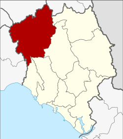 District location in Chanthaburi Province | |
| Coordinates: 13°0′30″N 101°54′18″E | |
| Country | Thailand |
| Province | Chanthaburi |
| Seat | Kaeng Hang Maeo |
| Area | |
| • Total | 1,254.1 km2 (484.2 sq mi) |
| Population (2005) | |
| • Total | 36,453 |
| • Density | 29.1/km2 (75/sq mi) |
| Time zone | UTC+7 (ICT) |
| Postal code | 22160 |
| Geocode | 2208 |
Geography
Neighboring districts are (from the east clockwise) Soi Dao, Khao Khitchakut, Tha Mai, Na Yai Am of Chanthaburi Province, Klaeng, Khao Chamao of Rayong Province, Bo Thong of Chonburi Province, Tha Takiap of Chachoengsao Province and Wang Sombun of Sa Kaeo Province.
History
The minor district (king amphoe) Kaeng Hang Maeo was established on 1 April 1990 by splitting off five tambon from Tha Mai District.[1] It was upgraded to a full district on 8 September 1992.[2]
Administration
The district is divided into five sub-districts (tambons), which are further subdivided into 62 villages (mubans). There are no municipal (thesabans). There are five tambon administrative organizations (TAO).
| No. | Name | Thai name | Villages | Pop. | |
|---|---|---|---|---|---|
| 1. | Kaeng Hang Maeo | แก่งหางแมว | 21 | 8,395 | |
| 2. | Khun Song | ขุนซ่อง | 17 | 10,671 | |
| 3. | Sam Phi Nong | สามพี่น้อง | 9 | 5,345 | |
| 4. | Phawa | พวา | 12 | 9,086 | |
| 5. | Khao Wongkot | เขาวงกต | 3 | 2,956 |
References
- ประกาศกระทรวงมหาดไทย เรื่อง แบ่งเขตท้องที่อำเภอท่าใหม่ จังหวัดจันทบุรี ตั้งเป็นกิ่งอำเภอแกงหางแมว (PDF). Royal Gazette (in Thai). 107 (25 ง): 1348. 13 Feb 1990.
- พระราชกฤษฎีกาตั้งอำเภอด่านมะขามเตี้ย อำเภอแก่งหางแมว อำเภอภักดีชุมพล อำเภอเวียงแก่น อำเภอแม่วาง อำเภอถ้ำพรรณรา อำเภอบ่อเกลือ อำเภอโนนสุวรรณ อำเภอห้วยราช อำเภอแม่ลาน อำเภอบางแก้ว อำเภอป่าพะยอม อำเภอหนองม่วงไข่ อำเภอยางสีสุราช อำเภอจังหาร อำเภอบ้านธิ อำเภอภูสิงห์ อำเภอบางกล่ำ อำเภอวังม่วง และอำเภอนายูง พ.ศ. ๒๕๓๘ (PDF). Royal Gazette (in Thai). 112 (32 ก): 1–3. 8 Aug 1995.