Bo Thong District
Bo Thong (Thai: บ่อทอง, pronounced [bɔ̀ː tʰɔ̄ːŋ]) is a district (amphoe) in Chonburi Province, Thailand.
Bo Thong บ่อทอง | |
|---|---|
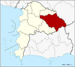 District location in Chonburi Province | |
| Coordinates: 13°16′43″N 101°26′25″E | |
| Country | Thailand |
| Province | Chonburi |
| Seat | Bo Thong |
| Tambon | 6 |
| Area | |
| • Total | 781.6 km2 (301.8 sq mi) |
| Population (2015) | |
| • Total | 49,623 |
| • Density | 63.48/km2 (164.4/sq mi) |
| Time zone | UTC+7 (ICT) |
| Postal code | 20270 |
| Geocode | 2010 |
History
Bo Thong was originally a tambon of Phanat Nikhom District. On 16 December 1978 the minor district (king amphoe) was created.[1] On 16 March 1985 it was upgraded to a full district.[2]
Geography
Neighboring districts are (from the north clockwise) Ko Chan of Chonburi Province, Tha Takiap of Chachoengsao Province, Kaeng Hang Maeo of Chanthaburi Province, Khao Chamao and Wang Chan of Rayong Province, and Nong Yai, Ban Bueng and Phanat Nikhom of Chonburi.
Khao Cha-ang (เขาชะอางค์) is an isolated limestone mountain standing on a plain in Bo Thong District. It is an important source of gold and antimony.
Administration
The district is divided into six sub-districts (tambons), which are further subdivided into 47 villages (mubans). Bo Thong is a sub-district municipality (thesaban tambon) which covers parts of the tambons Bo Thong and Wat Suwan. That Thong is a sub-district municipality which covers the whole same-named sub-district. There are a further five tambon administrative organizations (TAO).
| No. | Name | Thai | Villages | Pop.[3] |
|---|---|---|---|---|
| 1. | Bo Thong | บ่อทอง | 9 | 13,509 |
| 2. | Wat Suwan | วัดสุวรรณ | 7 | 6,185 |
| 3. | Bo Kwang Thong | บ่อกวางทอง | 8 | 6,513 |
| 4. | That Thong | ธาตุทอง | 9 | 7,500 |
| 5. | Kaset Suwan | เกษตรสุวรรณ | 7 | 6,631 |
| 6. | Phluang Thong | พลวงทอง | 7 | 7,850 |
References
- ประกาศกระทรวงมหาดไทย เรื่อง แบ่งท้องที่อำเภอพนัสนิคม จังหวัดชลบุรี ตั้งเป็นกิ่งอำเภอบ่อทอง (PDF). Royal Gazette (in Thai). 95 (110 ง): 3332. October 10, 1978.
- พระราชกฤษฎีกาตั้งอำเภอเขาสวนกวาง อำเภอแปลงยาว อำเภอบ่อทอง อำเภอปะคำ และอำเภอบ้านฉาง พ.ศ. ๒๕๒๘ (PDF). Royal Gazette (in Thai). 102 (33 ก ฉบับพิเศษ): 7–9. March 15, 1985.
- "Population statistics 2012". Department of Provincial Administration.