Malaysia–Singapore Second Link
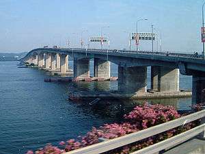
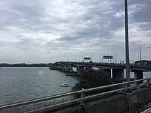
The Malaysia–Singapore Second Link (Malay: Laluan Kedua Malaysia–Singapura, Chinese: 马新第二通道) is a bridge connecting Singapore and Johor, Malaysia. In Singapore, it is officially known as the Tuas Second Link. The bridge was built to reduce the traffic congestion at the Johor–Singapore Causeway, and was opened to traffic on 2 January 1998.[1] It was officially opened by Singapore's then Prime Minister Goh Chok Tong with his counterpart, Dr Mahathir Mohamed, who was then Prime Minister of Malaysia. The bridge supports a dual-three lane carriageway linking Kampong Ladang at Tanjung Kupang, Johor to Jalan Ahmad Ibrahim at Tuas, Singapore. The total length of the bridge over water is 1,920 metres (6,300 ft).
Malaysia–Singapore Second Link Laluan Kedua Malaysia–Singapura 马新第二通道 | |
|---|---|
 | |
| Coordinates | 1°21′03″N 103°37′59″E |
| Carries | Motor vehicles |
| Crosses | Straits of Johor |
| Locale | Tanjung Kupang, Johor, Malaysia and Tuas, Singapore |
| Official name | Malaysia–Singapore Second Link |
| Maintained by | PLUS Expressways (Malaysia) Land Transport Authority (Singapore) |
| Characteristics | |
| Design | Box girder bridge |
| Total length | 1,920 metres (6,300 ft) |
| Width | 25 metres (82 ft) |
| Longest span | 150 metres (490 ft) |
| History | |
| Designer | Government of Malaysia Malaysian Highway Authority United Engineers Malaysia Berhad Government of Singapore Land Transport Authority |
| Constructed by | United Engineers Malaysia Berhad |
| Opened | 2 January 1998 |
| Inaugurated | 18 April 1998 |

| |
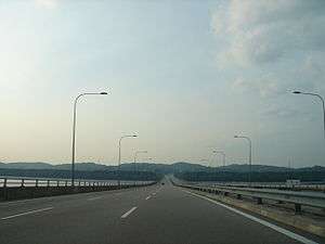
At Malaysian side, the bridge is connected to the Second Link Expressway (Malay: Lebuhraya Laluan Kedua Malaysia–Singapura) E3 also known as Linkedua Expressway, which links from Senai North Interchange Exit 253 at North–South Expressway E2, Senai Airport and Taman Perling, Johor Bahru via its extension known as Johor Bahru Parkway E3. In Singapore, the bridge connects to the Ayer Rajah Expressway.
The checkpoint on Malaysia side is called the Sultan Abu Bakar CIQ Complex. The checkpoint on Singapore side, the Tuas Checkpoint, was built on 19.6 hectares (48 acres) of reclaimed land at a cost of S$485 million. Designed by CPG Corporation, it involved the use of 54,000 cubic metres (1,900,000 cu ft) of concrete and 18,000 tonnes (20,000 short tons) of reinforcing steel, and won the Architectural Design Award and Best Buildable Design Award awarded by the Singapore Institute of Architects and the Building and Construction Authority respectively.[2] Travelling along the Second Link usually takes less time than the Causeway due to smoother traffic in both directions; however, during festive periods (especially Chinese New Year, Hari Raya, Christmas and Deepavali) the dense traffic between Malaysia and Singapore still leads to massive jams on both bridges.
Like its counterparts in Woodlands, as Tuas Checkpoint is designated as a vehicular checkpoint only, travellers are not allowed to enter the checkpoint on foot. Passengers may head to Tuas Link MRT station to use Transtar Cross Border TS6[3] or Causeway Link CW7.
Access from other roads
From Malaysia
The approach to the bridge is via the Second Link Expressway, which can be accessed by exiting the North–South Expressway (E2) at Exit 253 Senai North Interchange. Alternatively, motorists can also enter the expressway via Taman Perling which also joins with Pasir Gudang Highway (Federal Route 17 and Skudai Highway (Federal route 1). The expressway link to Taman Perling is also known as Pontian–Johor Bahru Parkway.
From Singapore
The bridge is directly accessed via the Ayer Rajah Expressway, along with other supporting roads around the vicinity of the Tuas industrial area.
History
The idea of building a second link between Malaysia and Singapore was first raised in July 1980 by then-Menteri Besar of Johor, Othman Saat. Gelang Patah was raised as a viable site due to its distant proximity from Johor Bahru, and the suggestion was raised to tackle growing traffic jams on the causeway.[4] The Malaysian federal Government welcomed Othman's plan, and the Johor State Government formed a committee to study the feasibility of building the second link.[5]
In July 1989, United Engineers Malaysia Berhad (UEM) submitted a proposal to the government of Malaysia to privatise the construction of a second link to Singapore. The acceptance of the proposal brought about the signing of a concession agreement in July 1993, giving exclusive rights and authority to UEM to design, construct, manage, operate and maintain the bridge and expressways for a period of 30 years commencing 27 July 1993.
Following this, a novation agreement was executed in May 1994, whereby UEM assigned all its rights, liabilities and obligations in respect of the concession agreement to Linkedua (Malaysia) Berhad, a wholly owned subsidiary of UEM.
The construction of the bridge required the co-operation of the government of Malaysia and the government of the Singapore. On 22 March 1994, an inter-government agreement was signed defining the responsibilities of both governments with regard to the design, construction, operation, and maintenance of the bridge. Each government was responsible for the construction of the portion the bridge which fell within its borders, based on a common agreed design. A joint committee comprising representatives of each government was formed to oversee the implementation of this Malaysia–Singapore Second Crossing project.
The major components of the project are the Second Crossing bridge, forty-four kilometres of expressways, a Customs, Immigration and Quarantine complex, three toll plazas, two rest and service areas and other ancillary facilities. The bridge was designed to accommodate up to 200,000 vehicles a day.
The Second Link was opened to traffic on 2 January 1998. It was officially opened on 18 April the same year by the Prime Ministers of both countries, namely Dato' Seri Dr. Mahathir Mohamad of Malaysia and Goh Chok Tong of Singapore.
2020 Malaysia movement control order
On 16 March 2020, Malaysian Prime Minister Muhyiddin Yassin announced on television that Malaysia will be implementing Movement Control Order, in what was described as Malaysia Partial Lockdown and Malaysia Lockdown in local and international media [6]. This was in response to the increasing COVID19 cases.
On 17 March 2020, the Causeway was facing immense jams due to the order being kicked from 18 March 0000. All bus services will not enter Johor Bahru for two weeks from 18 March to 31 March 2020.[7] However, the flow of cargo, goods and food supplies will carry on as per normal.[8]
Navigational channels
When travelling by sea, navigational aids consists of lights mounted on the bridge piers and lighted buoys placed at strategic navigational locations. The three sea channels dimensions are 75 metres (246 ft) wide by 25 metres (82 ft) high; 50 metres (160 ft) wide by 9 metres (30 ft) high; and 75 metres (246 ft) wide by 12 metres (39 ft) high.
Major events
Johor–Singapore International 2nd Link Bridge Run
Since 1999, an annual 2nd Link Bridge Run is organised to promote sports and cross-border ties. Both countries take turns to host the event that has seen increasing numbers of participants.
Technical specifications
Bridge Specifications
- Overall length of bridge: 1,920 metres (6,300 ft)
- Length within Malaysian waters: 1,769 metres (5,804 ft)
- Construction period: Oct 1994 to Oct 1997
- Total length of piles: 10,230 metres (33,560 ft)
- Total volume of concrete: 54,000 cubic metres (1,900,000 cu ft)
- Total weight of reinforcing steel: 18,000 tonnes (20,000 short tons)
- Total number of precast box segments: 840 units
- Longest span: 165 metres (541 ft)
Navigational Channels
- Malaysian main navigational channel: 75 metres (246 ft) wide by 25 metres (82 ft) high.
- Malaysian secondary navigational channel: 50 metres (160 ft) wide by 9 metres (30 ft) high.
- Singaporean navigational channel: 75 metres (246 ft) wide by 12 metres (39 ft) high
Public bus transport
Causeway Link Routes CW3, CW4, CW6 and CW7 from Jurong East, Boon Lay & Tuas Link in Singapore to Bukit Indah, Gelang Patah, Pontian & Legoland in Malaysia cross this border daily.
Transtar Travel Routes TS6 & TS6A from Bouna Vista & Changi Airport via one-north & Tuas Link in Singapore to Legoland, Puteri Harbour & Gelang Patah Sentral in Malaysia cross this border daily. Do note that passengers should inform the driver where they will be alighting at when boarding the bus.
See also
| Wikimedia Commons has media related to Malaysia-Singapore Second Link. |
References
- http://eresources.nlb.gov.sg/infopedia/articles/SIP_844_2005-01-07.html
- "Archived copy". Archived from the original on 29 September 2007. Retrieved 2 October 2006.CS1 maint: archived copy as title (link)
- "Transtar TS6".
- Bernama, Causeway or Free Trade Zone request, p. 12, 14 July 1980, New Straits Times
- "Panel set up to study link Proposal", p. 8, 17 December 1980, New Straits Times
- https://www.thestar.com.my/news/nation/2020/03/16/malaysia-announces-restricted-movement-measure-after-spike-in-covid-19-cases
- https://www.straitstimes.com/singapore/transport/bus-services-170x-and-950-suspended-till-march-31-other-services-halt-malaysia
- https://www.channelnewsasia.com/news/singapore/singapore-malaysia-cargo-goods-border-restrictions-12547142
External links
Singapore
Others
- Google Maps link showing the Second Link, with Tanjung Kupang, Malaysia, at left and Tuas, Singapore, at right.
| Present connections |
| ||||
|---|---|---|---|---|---|
| Planned projects |
| ||||
italics indicated the project is under construction. | |||||