Ibar (river)
The Ibar, also known as the Ibër and Ibri (Albanian: Ibër, Ibri, Serbian Cyrillic: Ибар, pronounced [îbar]), is a river that flows through eastern Montenegro, Serbia and Kosovo,[lower-alpha 1] with a total length of 272 km (169 mi).[1] The river begins in the Hajla mountain, in Rožaje, eastern Montenegro, and passes through Kosovo to flow into the West Morava river near Kraljevo, central Serbia.
| Ibar Ибар, Ibër, Ibri | |
|---|---|
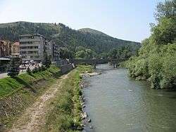 Ibar River in Raška | |
| Location | |
| Country | Kosovo, Montenegro, Serbia, |
| Physical characteristics | |
| Source | |
| • location | Hajla mountain, Rožaje, eastern Montenegro |
| Mouth | |
• location | into West Morava at Kraljevo |
• coordinates | 43°43′39″N 20°44′58″E |
| Length | 272 km (169 mi)[1] |
| Basin size | 7,925 km2 (3,060 sq mi)[2] |
| Basin features | |
| Progression | West Morava→ Great Morava→ Danube→ Black Sea |
It belongs to the Black Sea drainage basin. Its own drainage area is 7,925 km2 (3,060 sq mi),[2] with an average discharge of 60 m³/s at the mouth. It is not navigable.
Etymology
Perhaps the same as basque ibar "valley", or from the albanian i bardhë "the white".
Upper course
The Ibar originates from six springs on the Hajla mountain in eastern Montenegro. It generally flows north-east, passing through Ibarac, Rožaje, Radetina and Bać, after which it enters Serbia. Passing through the most southern part of Raška District, it flows through several small villages, but this is one of the least populated areas of Kosovo. In this whole area, the river has no major tributaries, but many short streams which flow into it from surrounding mountains. This part also represents the route of one of two main roads connecting Serbia and Montenegro (Ibarska magistrala). At a point near the village of Vitkovići, it turns south and enters Kosovo.
Middle course
Continuing south, the river passes through Gazivode, Zubin Potok, Ugljare, Zupče and Šipolje, reaching the city of Mitrovica. There, it makes a sharp, elbow turn to the north, flowing through Zvecan, Slatina, Socanica, Leposavic, Dren and Lesak, entering central Serbia proper at the village of Donje Jarinje.
At Kosovo, the river is dammed, creating the artificial Lake Gazivoda (area 11.9 km2 or 4.6 sq mi, altitude 693 m or 2,274 ft, depth 105 m or 344 ft). Water from the lake is used for industrial and mining facilities in the Mitrovica/Trepca area. Below Gazivoda another reservoir is created, Lake Pridvorice. These lakes allow irrigation of an area of 300 km², representing part of a plan, never completed, of a huge Ibar-Lepenac Hydrosystem, which was supposed to regulate the Ibar-Sitnica-Lepenac watercourse (including ecological protection, irrigation and power production).
At Mitrovica, the river enters a minerals and ore rich area of the western slopes of Kopaonik mountain, which it follows for the next 100 km (62 mi) or so. The area is especially rich in lead, zinc and silver (Stari Trg, Trepča and Leposavić mines).
Right on its elbow turn, the Ibar receives its longest (right) tributary, the Sitnica.
Entering central Serbia again, the river receives its major tributaries: the Raška, Studenica and Lopatnica, from the left, and the Jošanica.
In this section, the river has carved the 40 km (25 mi) long and 550 m (1,804 ft) deep Ibar gorge, which is the natural route for the major road in this part of Serbia, the Ibar Highway. This stretch of the river is famous for its pinched meanders and gigantic whirlpools. The whole area is 110 km (68 mi) long (meridionally stretched), and at Serbia's parts is popularly divided into several colorfully named valleys:
- Dolina istorije (Serbian: Долина историје; Valley of history), consisting of ruins of the medieval city of Maglič, the monastery of Studenica, the monastery of Žiča, the monastery of Gradac, etc.;
- Dolina jorgovana (Serbian: Долина јоргована; Valley of the lilacs);
- Dolina banja (Serbian: Долина бања; Valley of the spas), with many spas and springs, such as Jošanička Banja, Mataruška Banja and Bogutovačka Banja.
The gorge is carved between the mountains of Golija, Čemerno and Troglav from the east, and Kopaonik, Željin and Stolovi from the west.
This is a continuation of Kopaonik's mining rich area, including deposits of iron ore (Kopaonik, Raška), nickel (Kopaonik), asbestos (Brvenik), magnesite (Bela Stena) and hard coal (Baljevac, Ušće and Jarando).
The Ibar has previously gained notoriety as being the most polluted river in Serbia (together with its major tributary, the Sitnica), especially from frequent spills of extremely poisonous phenol, which causes constant problems for the population of Kraljevo, since the city uses the river's water for public waterworks.
See also
- Rivers of Kosovo
- List of rivers of Europe
- Rivers of Serbia
- Rivers of Montenegro
Notes and references
Notes:
- Kosovo is the subject of a territorial dispute between the Republic of Kosovo and the Republic of Serbia. The Republic of Kosovo unilaterally declared independence on 17 February 2008, but Serbia continues to claim it as part of its own sovereign territory. The two governments began to normalise relations in 2013, as part of the 2013 Brussels Agreement. Kosovo is currently recognized as an independent state by 97 out of the 193 United Nations member states. In total, 112 UN member states recognized Kosovo at some point, of which 15 later withdrew their recognition.
References:
| Wikimedia Commons has media related to Ibar. |
- Statistical Yearbook of the Republic of Serbia 2017 (PDF) (in Serbian and English). Belgrade: Statistical Office of the Republic of Serbia. October 2017. p. 16. ISSN 0354-4206. Retrieved 30 May 2018.
- Velika Morava River Basin, ICPDR, November 2009, p. 2
- Mala Prosvetina Enciklopedija, Third edition (1985); Prosveta; ISBN 86-07-00001-2
- Jovan Đ. Marković (1990): Enciklopedijski geografski leksikon Jugoslavije Svjetlost-Sarajevo; ISBN 86-01-02651-6
| Authority control |
|---|