Hajla
Hajla is a mountain located between Kosovo[a] and Montenegro. It has several peaks that reach over 2,000 m (6,562 ft), the highest having 2,403 m (7,884 ft) which is also called Hajla. In the northern slopes contains the spring formation of the Ibar river, and to its southern slopes is the origin of the Bistrica e Pejes (or the Pećka Bistrica) river. Hajla is also the highest mountain in the northern part of the Accursed Mountains of the Balkans. In Kosovo, Hajla forms part of the 25 km (16 mi) long Rugova Canyon. The nearest city to Hajla is Rožaje, in Montenegro.
| Hajla | |
|---|---|
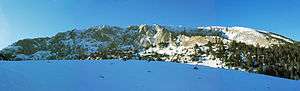 Panorama | |
| Highest point | |
| Elevation | 2,403 m (7,884 ft) [1] |
| Coordinates | 42°46′24″N 20°16′21″E |
| Geography | |
 Hajla | |
| Climbing | |
| Easiest route | Pejë-Pepaj or Rožaje-Bandžov-Dermandol[2][3] |
Highest peaks
- Hajla (2,403 m or 7,884 ft)
- Hajla e Vëranocit (2,281 m or 7,484 ft)
- Maja Dramadol (2,120 m or 6,955 ft)
- Hajla e Shkrelit (2,011 m or 6,598 ft)
See also
Notes and references
Notes:
| a. | ^ Kosovo is the subject of a territorial dispute between the Republic of Kosovo and the Republic of Serbia. The Republic of Kosovo unilaterally declared independence on 17 February 2008, but Serbia continues to claim it as part of its own sovereign territory. The two governments began to normalise relations in 2013, as part of the 2013 Brussels Agreement. Kosovo is currently recognized as an independent state by 97 out of the 193 United Nations member states. In total, 112 UN member states recognized Kosovo at some point, of which 15 later withdrew their recognition. |
References:
- Jovan Đokić. "Katalog planina Srbije". PSD Kopaonik Beograd. Archived from the original on 2011-05-18.
- Peć
- Rugova Mountains
This article is issued from Wikipedia. The text is licensed under Creative Commons - Attribution - Sharealike. Additional terms may apply for the media files.