Howesville, Indiana
Howesville is an unincorporated community in Lewis Township, Clay County, Indiana. It is part of the Terre Haute Metropolitan Statistical Area.
Howesville | |
|---|---|
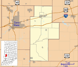 Howesville Location in Clay County | |
| Coordinates: 39°10′37″N 87°08′49″W | |
| Country | United States |
| State | Indiana |
| County | Clay |
| Township | Lewis |
| Elevation | 548 ft (167 m) |
| ZIP code | 47438 |
| FIPS code | 18-35014[1] |
| GNIS feature ID | 436555[2] |
History
Howesville was laid out in 1856.[3] A post office was established in Howesville in 1858, and remained in operation until it was discontinued in 1909.[4]
Geography
Howesville is located at 39°10′37″N 87°08′49″W.
References
- "U.S. Census website". United States Census Bureau. Retrieved 2008-01-31.
- "Howesville, Indiana". Geographic Names Information System. United States Geological Survey. Retrieved 2009-10-17.
- Blanchard, Charles (1884). Counties of Clay and Owen, Indiana: Historical and Biographical. F.A. Battey & Company. pp. 332.
- "Clay County". Jim Forte Postal History. Retrieved 30 August 2014.
Municipalities and communities of Clay County, Indiana, United States | ||
|---|---|---|
| City | Map of Indiana highlighting Clay County | |
| Towns | ||
| Townships | ||
| CDP | ||
| Other unincorporated communities |
| |
| Ghost towns | ||
| Footnotes | ‡This populated place also has portions in an adjacent county or counties | |
This article is issued from Wikipedia. The text is licensed under Creative Commons - Attribution - Sharealike. Additional terms may apply for the media files.